

For updates see my Curriculum Vitae.
3/15/2015: Received $10,000 grant from the Delaware, Knox, Marion, Morrow (DKMM) Joint Solid Waste District for OWU's May Move Out effort for 2015.
2/15/2015: Funding approved for a travel learning course to Costa Rica, with a focus on community gis & geography & data collection. In collaboration Amy Work (OWU, 2006).
1/5/2015: A brief essay "Reflections on J.B. Harley's 'Deconstructing the Map'" will be published as part of a special 2015 issue of the journal Cartographica entitled Deconstructing the Map: 25 Years On. A page proof of the essay is here.
1/5/2015: A new web site for our Engaging Columbus project is up and semi-coherent. The site combines diverse historical (and some contemporary) data about Columbus - including old real estate atlases, ethnic and racial data, census data, panoramic views, etc. and is going to be used in two courses on urban geography and the environment this spring semester. More details in the 11/2014 posting on the project below.
12/16/2014: Our new physical/environmental geographer Nathan Amador and I received funding to include a travel component in Nathan's fall 2015 semester Environmental Alteration course. Students will work on collecting local (Delaware, Ohio) environmental data while understanding how such local data relates to broader regional and global data, with a particular focus on global climate change. The students will then travel to Uvita, Costa Rica to work with OWU alumni Amy Work (2004), who manages the non-profit Geoporter - a community geography, mapping and spatial data focused organization. The students will co-collect local data in Costa Rica with Amy and her community partners, providing comparative (local) data, also analyzed and understood in the context of climate change. The proposal for the travel course is here.
12/15/2014: My student assistant Christian Gehrke profiled in the OWU online news: High-Flying Research.
11/2014: Presented at the Digital Scholarship Colloquium 2014: Pedagogy and Practices, at Case Western Reserve University in Cleveland. The presentation is on the collaborative project to make historical real estate atlas maps (Baist's Atlases of 1899, 1910, 1920) available as map apps to be used in courses at Ohio Wesleyan and Denison (Spring of 2015). A PDF of the presentation is Here!
10/2014: A coalition of Columbus organizations (CUGER) I am working with developed a proposal for ecological restoration and trail development in the Glen Echo Ravine in Columbus, as mentioned below. Our proposal to mount a capital campaign to raise the funds for the project was awarded a $17,000 feasibility study grant. The Grant is from the Columbus Foundation and the feasibility study being conducted by the Benefactor Group. At this time, dozens of interviews are being conducted to determine the feasibility of our proposed campaign. I have learned way more than I ever thought I would about non-profit fund raising campaigns.
8/2014: A series of A map app for our Baist Atlas (1899, 1910, 1920) project is online, showing the three atlases, side by each (the way they park cars in Providence, RI). More apps related to the project are Here. The project is funded by a Mellon Foundation grant and involves a collaboration between OWU, Denison University and the City of Columbus. On the Baist's Atlases: Three large historical real estate atlases of Columbus, Ohio were created and published by the G. William Baist Company of Philadelphia, Pennsylvania, in 1899, 1910, and 1920. The maps in Baist's atlases were created for real estate title searches and include detailed building, subdivision, infrastructure and street data. They were beautifully designed and colored, and produced for dozens of U.S. cities, but in small quantities. Most were heavily used, annotated, worn out and eventually discarded by their users. Few Columbus atlases survive and none were available in digital form.
11/2013: I have managed to get myself involved in a rather substantial project focused on one of the ravine areas in my Columbus neighborhood - Glen Echo Ravine. This project developed from our Urban Arboretum work. Quoting our current rather ambitious plan: "Glen Echo Ravine and Stream comprise a surprisingly rich ecological space bisecting the 100-year-old neighborhoods on the north side of Columbus, Ohio. Hundreds of species of birds, animals, insects, trees and plants coexist in a unique ravine environment within steps of homes and businesses. Limited funds for bridge maintenance along N. High St. in the early part of the great depression resulted in the filling of the half dozen ravines under and adjacent to the historic road, including Glen Echo Ravine. Ecological concerns as well as the well recognized correlation between environmentally friendly urban neighborhoods and livability, commercial vitality and property values strongly supports our proposal to purchase and transform the current White Castle property - one of the filled in ravine parcels. Continued improvement to this distinguishing and defining part of the community will benefit the environment, residents and businesses in Old North Columbus and Clintonville. We envision the intersection of High St. and Glen Echo Ravine as a unique urban ecological hub that will come to define our neighborhood long into the future.
6/2013: Working on a new (3rd) edition of the Making Maps book with Denis Wood.
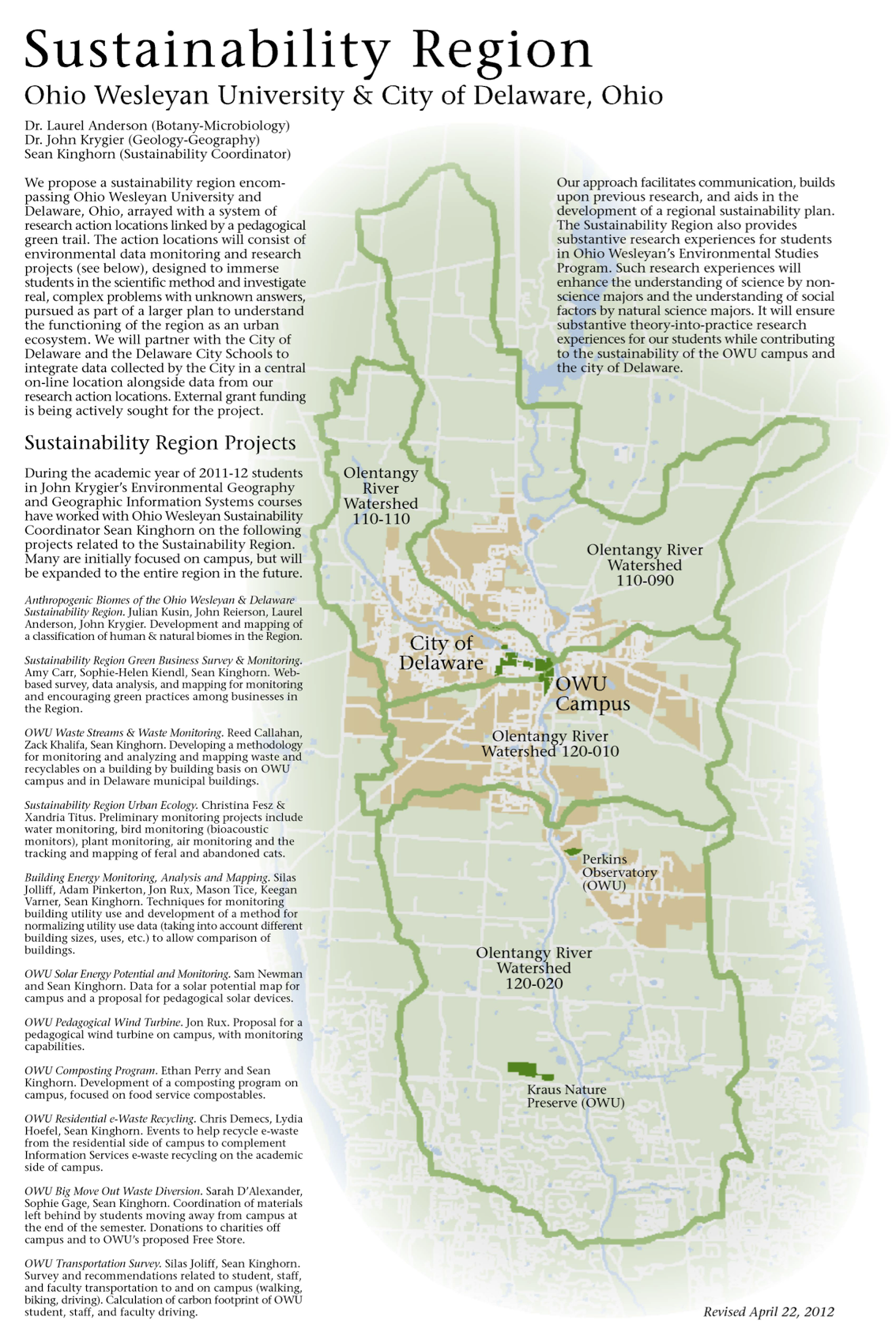
3/2013: Environmental Studies, the Sustainability Region and the proposed OWU Center for the Environment: Laurie Anderson (Botany), myself and the faculty who teach courses in our Environmental Studies Program have been engaged in a 3 year process reviewing, revising and expanding the program. The proposed OWU Center for the Environment consists of an enhanced Environmental Studies program focused on active student learning about sustainability and the environment in the region surrounding Ohio Wesleyan Campus.
12/2012: Continuing work on the Lower Olentangy Urban Arboretum (LOUA) project in my neighborhood
of Clintonville in north Columbus, Ohio. The project, inspired by OWU's campus Decker Arboretum,
focuses on generating grant money to fund the purchase and planting of high quality
native species trees in the tree lawns of our part of the city. The city does not typically
plant native species, such as oaks, due to their cost. Many hundreds of trees have been
planted in the last two years, and the boundaries of the Urban Arboretum are expanding. We
developed a pair of walks and maps
of the Arboretum, and have a project blog.

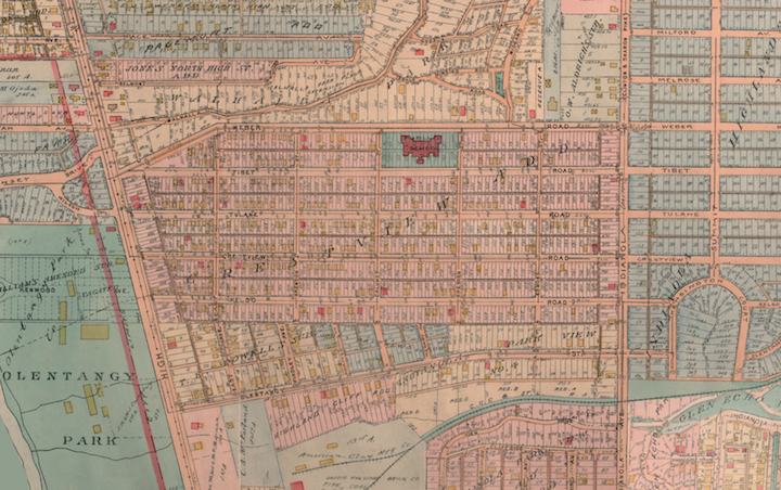
3/2012: Completed work funded by a Mellon grant to scan and georectify three old
real estate
atlases from Columbus Ohio created by the G. William Baist Company of Philadelphia. These are
very rare atlases (only a few copies of each exist) and the Columbus atlases had never before
been scanned. The atlases were used to check legal property data. Link below goes to an example
plate, the Clintonville area of Columbus in 1920.

6/10: Presenting two days of stuff at the Newberry Library and NEH sponsored institute Mapping and Art in the Americas in Chicago. Neato.
5/10: Presenting at Ohio State University Department of Geography: "27 Deep Thoughts about Writing a Textbook."
4/10: Dropped just about everything to finish the 2nd edition of Making Maps: A Visual Guide to Map Design for Geographic Information Systems. It is completely redesigned from scratch (what is scratch?) with over 60% new or updated content. It should be published early in 2011. It's posh!

4/10: Denis' just-about all new Rethinking the Power of Maps is out with Jon Fels and me myself added as contributors (each of us worked with Denis on a few sections of the book, but Denis re-wrote everything).

6/09: Baffy Guide Psychogeographique de OWU map completed in Mapping Weird Stuff summer course for smart middle school kids.
6/09: Continued posting of cartominutiae, assorted oddments, and minor outrages to the Making Maps blog.
6/09: Start working with Denis Wood on a 2nd edition of Making Maps: A Visual Guide to Map Design for Geographic Information Systems.
6/09: Apparently invited to the Scholarly Communication Institute 7: Spatial Technologies and Methodologies.
6/09: Denis & my scandalous comic "Ce n'est pas le monde" published in the fabulously scholarly tome Rethinking Maps: New Frontiers in Cartographic Theory. "an experiment in rethinking maps and discourse about maps: a proposition about maps as propositions and about comic books as academic discourse in the form of a comic book of propositional maps."
4/09: Done with revisions on four scintillating articles - "Map," "Protest Maps," "Critical Cartography," "Map Types" - for a massive clunk of a publication, The Encyclopedia of Human Geography (New York: Elsevier, to be published late 2009). My favorites are "Map Types" (disheveling categories in mapping) and "Map" (more scandal: argues that maps don't really exist prior to 1500 or so).
1/09: "Mapping ambivalence: Exploring the geographies of community change and rails-to-trails development using photo-based Q method and PPGIS" (coauthored with Tim Hawthorne & Mei-Po Kwan) published in Geoforum. This was Tim's senior research project at OWU. We used the crazy hybrid qual/quant Q method to sort out reactions to proposed recreational trails, linked to how near or far people were from the proposed trails. Counters "NIMBY" assumptions.
9/08: "Hey Map - Who Are You?" words / graphics presented at Counter Cartography Colloquium, University of North Carolina. "People are remade in diverse ways by maps within particular contexts and cultures ... people are constantly in a state of becoming; constantly being remade." CartoPanpsychism: do maps have minds? Are maps autistic? Panautism. Maps as idiot savants. Neuroplasticity. Yikes: someone said, after the talk, that some people were "disturbed" by the talk.
3/08: "Are Maps Autistic?" words / graphics presented at 2008 Association of American Geographers Meeting in Boston MA. Maps not representations. Maps constantly bring people into being: Map People. Do maps have agency? Mind? Diagnosis. I don't think people got it.
9/07: unMaking Maps project: Making Flat Earth Globes. Quite popular among the Flat Earth Society folks.
9/06: unMaking Maps video: Sawed Atlas/ Atlas of the North | Atlas of the South. Noisy.
9/06: unMaking Maps video: Drilled Atlas/ Puncture Atlas of the U.S.
9/06: unMaking Maps: ParaCartographic Experiments presented at 2006 CONFLUX / Psychogeography swarm, Brooklyn, NY. Presented in a dark, cramped, hot bar in Williamsburg whilst I was suffering from a sinus infection. Very fun. Slept on the floor of Lilla and Bill's studio.
3/07: Melissa Gilbert & I publish "Mapping Campus-Community Collaborations: Integrating Partnerships, Service-Learning, Mapping and GIS" in Diana Sinton & Jenny Lund (eds.) Understanding Place: GIS and Mapping Across the Curriculum. Redlands CA: ESRI Press. A nice overview of service-learning issues for newbies.
3/06: Denis & I organize & edit Art & Cartography Special Issue including "Map Art" (Denis Wood), "Interpreting Map Art" (Dalia Varanka), "Art-Machines, Body-Ovens and Map-Recipes: Entries for a Psychogeographic Dictionary" (kanarinka), and "Jake Barton's Performance Maps" (John Krygier) published in Cartographic Perspectives 53.
5/06: Jeremy Crampton & I publish "An Introduction to Critical Cartography" in ACME: An International e-Journal for Critical Geographies (4:1).
older...
��
My research focuses on the relations between geography and geographic
methods - mapping, visualization, and GIS. Particular research projects
are described below...

The last decade has seen explosive growth in the development and use of
geographic information systems (GIS). As GIS develops and plays an
expanding role in the way we manage, analyze, and understand spatial
phenomena, the societal consequences of GIS come to the forefront of
research in GIS. Research on GIS and Society is important not only as a
means of understanding the impact of existing technologies on society,
but in also imagining and engineering new technologies, for scientists,
researchers, and the diverse public who increasingly have access to GIS
and its analytical capabilities. A developing area of research in GIS
is what is being called Participatory GIS.
An Overview of Participatory GIS,
Community Mapping, and GIS was prepared for a presentation at Middlebury
College in January of 2004 and at Ohio Wesleyan in March of 2004. This overview
is being expanded into a presentation entitled Mapping Campus-Community Collaborations:
Integrating Partnerships, Service-Learning, Mapping and GIS for the 2004
National Meeting of the National Institute for
Technology and Liberal Education, called Voyage to Ithaka: Technology,
Collaboration, and the Future of Liberal Arts Colleges November 7-9,
2004. This presentation in turn is being expanded into a book chapter in the
book GIS for Learning and Engagement in Diverse Disciplines edited
by Diana Sinton and Jenni Lund.
Since 2000 my Ohio Wesleyan GIS course (Geog 355) has been working with Delaware (OH) community members and city planners in a collaborative project focused on developing a recreational trails plan for the City of Delaware. Basic details and images are included in a project overview: Delaware Ohio Recreational Trails GIS Collaboration.
Tim Hawthorne (an Ohio Wesleyan student) and I presented a paper entitled Mapping Linear Geographies at the 2003 AAG meeting in New Orleans. This paper was expanded into a paper entitled Mapping Ambivalence: Participatory GIS Methods, Qualitative Data, and Rails-to-Trails Development in a Changing Human Landscape. This research grew out of the Delaware Ohio Recreational Trails GIS Collaboration. LaDonna Knigge, Trevor Harris and I also organized a panel discussion for AAG 2003 entitled GIS and Society: Past, Present, and Future.
In May of 2004 I hosted a conference at Ohio Wesleyan called Mapping Campus-Community Collaborations: Integrating Partnerships, Service-Learning, Mapping and GIS. This conference was inspired by our work in Delaware, and funded by the Andrew Mellon Foundation via the Midwest Instructional Technology Center. The conference brought together teams of faculty, students, and community members with experts in mapping, GIS, service-learning, and community partnerships. Teams attended from Ohio Wesleyan, Otterbein, Middlebury, Swarthmore, Carleton, Wooster, Grinnel, Monmouth, Macalester, and Ripon Colleges. Each campus-community team arrived with a project idea that met an identified community need. Projects were iteratively developed over the course of the conference, resulting in a workable plan for action. Each project uses mapping and GIS, among other tools, to solve civic problems of shared concern to colleges and communities. Project updates will be added to the Mapping Campus-Community Collaborations WWW pages in the future.
An overview of Participatory GIS in the Liberal Arts will be presented at a meeting entitled Technology, Collaboration, and the Future of Liberal Arts Colleges in Chicago on November 7-9, 2004. A book chapter based on this presentation will appear in a book entitled GIS for Learning and Engagement in Diverse Disciplines edited by Diana Sinton.
From some of my older research on PGIS: Participatory GIS (PGIS) have been conceived broadly as an integrative and inclusive process-based set of methods and technologies amenable to public participation, multiple viewpoints, and diverse forms of information. A praxis or theorized practice of PGIS consists of an explicit awareness of the concepts and theories of information, its representation, of people, social relations, power, and how these shape and are shaped by socially-infused technologies such as PGIS. Simultaneously, such awareness must be brought to bear on real applications used by real people. A focus on only the practical (technical, software, hardware) or the conceptual (social, information, or cognitive theories) may limit the development of actual PPGIS and PPVis technologies in ways that substantially benefit real people in real communities. My past work on PGIS is documented here as Public Participation Visualization: Conceptual and Applied Research Issues. A summary of this work was published as A Praxis of Public Participation GIS and Visualization (published in 2002 in W. Craig, T. Harris, and D. Weiner, eds. Community Participation and Geographic Information Systems. New York: Taylor and Francis. pp. 330-345).

Peek out the page for a series of sessions at the March 2006 meeting of the Association of American Geographers annual meeting in Chicago called, alluringly, Experiments with Territories: Post Cartographic Map Design.
Geographic "visualization" is conceptualized as an expansion of the more traditional communication-oriented approach to cartography. Mapping | Geography | Landscape is an excerpt from my dissertation research which melds geographic visualization with research on landscape geography. An early theoretical and applied examination of visualization focused on the role of time in representing geographic information. Animation and the Role of Map Design in Scientific Visualization (published in 1992 in Cartography and Geographic Information Systems 19:4. pp. 201-214) grew out of a seminar at Penn State and was co-authored with David DiBiase, Alan MacEachren, and Catherine Reeves. Another examination of visualization in the context of scientific research explored methods for the visual representation of multivariate data, and was published as Multivariate Display of Geographic Data: Applications for Earth System Sciences (published in 1994 in A. MacEachren and D. Taylor, eds. Visualization in Modern Cartography. New York: Pergamon Press. pp. 287-312). Visual representations are not the only means of representing geographic information, and I have examined the role of sound in a paper called Sound and Geographic Visualization.
It is important to consider that visualization has both a history and a social context. A session at the 2000 Association of American Geographers meeting in Pittsburgh PA is entitled Visualization: Human, Social, and Historical Issues with Denis Cosgrove as a discussant and papers by Nik Huffman, Matthew Kuehl, Matt McCourt, and John Krygier. Envisioning the American West examines the manner in which text, images, maps, and panoramic views served as a means of representing the American West in the mid-19th century. As already noted, my dissertation research, Geography, Visualization, and Landscape, discusses the historical and social context of visualization, and develops and extended application of visualization in the realm of landscape and historical geography.
Recent research links visualization to GIS and the WWW - what I am calling Public Participation Visualization.
A draft paper entitled Cartographic Multimedia and Praxis in Human Geography and the Social Sciences was revised as a chapter in the book Multimedia Cartography edited by William Cartwright, Michael Peterson, and Georg Gartner published in 1999.
If blasphemy is the finest complement, then see The Science of Success in Cartography.

What are "marginal" landscapes and geographies? In order to examine such landscapes and the people who inhabit them I examined the story of Project Ketch in Pennsylvania. Ketch entailed a plan to explode a 24kt atomic bomb under central Pennsylvania to create a cavern for natural gas storage. Ketch was part of the Atomic Energy Commission's Project Plowshare which sought "peaceful" applications of atomic explosions. The paper on Ketch, Plowshare, and its relation to landscape, is entitled Spectacular Ideas in Marginal Landscapes: Project Plowshare in Pennsylvania. I am interested in the different ways marginality - in landscapes and humans - is constructed and utilized. A collection of images of "Marginal" Pennsylvania illustrate some curious "marginal landscapes." Another research interest concerns marginalized places and groups and the WWW. A paper entitled Community Networks, the Internet, and WWW in "Marginal" Places: The Case of Clinton County, Pennsylvania was presented at the 1997 Association of American Geographers meeting. The relations between marginal places and community networks, and in particular their role to mapping, GIS, and visualization are explored in an ongoing project called Public Participation Visualization: Conceptual and Applied Research Issues, the title of a presentation and poster presented at the 1998 Association of American Geographers Annual Meeting.
 Project
Peale: comprises an ongoing project to document, map,
interpret, and memorialize a ghost company town in Pennsylvania. Contributions
to the site have been made by people around the US and Europe.
Project
Peale: comprises an ongoing project to document, map,
interpret, and memorialize a ghost company town in Pennsylvania. Contributions
to the site have been made by people around the US and Europe.

The role of design in cartography and visualization seems to have diminished at the very moment it is needed most - during the explosion of computer-aided visualization and geographic information systems. The relationship between "art" and "science" in the context of cartography is critiqued in a paper called Cartography as an Art and a Science published in 1995 in the Cartographic Journal. This paper attempts to deal with some of the problematical ways cartographic design is thought about by cartographers. An examination of the relations between Geography and Cartographic Design is based on some early ideas from my dissertation research, and was published in C. Wood and C.P. Keller (eds.) Cartographic Design: Theoretical and Practical Perspectives (Chichester: John Wiley and Sons, 1996). If I can get my rear in gear, a book tentatively titled Making Maps on map design might eventually get published.

Research on Project Ketch and Project Plowshare, Spectacular Ideas in Marginal Landscapes: Project Plowshare in Pennsylvania examines the multiple and often contradictory understandings and representations of natural and human environments that emerge in environmental conflicts. Envisioning the American West examines the manner in which text, images, maps, and panoramic views served as a means of representing the environment of the American West in the mid-19th century. Both of these research projects reflect my interest in the discourses (visual, textual, spoken, in historical and contemporary settings) which underpin the manner in which we understand and act upon the environment.

A short essay entitled Place Taste and the Taste of Place documents Centralia Pennsylvania in text and images. Centralia is a coal mining town that has been the victim of a mine fire for more than 30 years.

The role of visualization, hypermedia, the WWW, and multimedia in education is of increasing importance to geographers. A paper about the use of multimedia in geography and earth science education, entitled Design, Implementation, and Evaluation of Multimedia Resources for Geography and Earth Science Education, describes the process of conceptualizing, designing, and producing a series of geography and earth science teaching resources. I have also made contributions to the Virtual Geography Department, an attempt to consolidate and coordinate geographic education materials on the WWW. The application of Information Literacy concepts to my Power of Maps and GIS course (Geography 222) is documented in a chapter by Deborah Carter Peoples (Ohio Wesleyan Science Librarian) and myself, called Geographic Information Literacy in a book edited by Michael Peterson, Maps and the Internet.

The WWW provides an interesting challenge to cartographers and information designers. Some of these challenges are cultural and social: a new research interest concerns marginalized places and groups and the WWW. A paper entitled Community Networks, the Internet, and WWW in "Marginal" Places: The Case of Clinton County, Pennsylvania was presented at the 1997 Association of American Geographers meeting, and the development of a series of issues which I am calling Public Participation Visualization. I have a simple Visual Guide to HTML (I am sure something like this exists somewhere but I couldn't find it). Jeremy Crampton (George Mason) and myself provided the general design and content for the web site for a new human geography textbook by Paul Knox and Sallie Marsden entitled Human Geography: Places and Regions in Global Context.
E-mail: jbkrygier@owu.edu