


The Beech Creek Railroad in the Peale, Pennsylvania Area
by Jeff Feldmeier,BeechCrRR@aol.com
Copyright Jeff Feldmeier, 2011.
The Beech Creek Railroad: Historical Background
The Village of Peale would never have come to be without the railroad. A means of transportation for the coal riches in the area was a must for the mineral to get to market. Having said that, oddly enough, the railroad never actually entered Peale proper. But we're getting ahead of ourselves a bit.
The purpose of this article is to provide a background history of the Beech Creek Railroad in the Peale area, including Gorton, Peale and Viaduct. Following a brief history of the Beech Creek Railroad itself, especially in regard to the Peale area, a description of key sites along the line will be described.
On January 11, 1883 an important agreement was signed between the Clearfield Bituminous Coal Company (CBC), who would operate many of the mines in the Peale area, the Susquehanna & South Western Railroad Company (the original name of the Beech Creek Railroad) and several other affiliated New York Central & Hudson River Railroad Company lines running from Jersey Shore Junction north into New York state. This agreement called for the construction of mines capable of producing 500,000 tons of coal annually plus 200 coke ovens with all tonnage to be moved over the railroads included in the agreement. The agreement was to last for 900 years! Thus, this paved the way for the CBC mines in the Peale area to ship their product over the Beech Creek.
The Clearfield Republican of March 21, 1883 reported that the Susquehanna & South Western Railroad Company was under construction westward from Jersey Shore, Pennsylvania. The day before, March 20, 1883, the railroad had already changed its name to that of the Beech Creek, Clearfield & South Western Railroad Company. The line was surveyed by Samuel Brugger and construction was under the control of General Contractor George J. Magee.
As the construction of the road continued westward, the Village of Peale was already being planned. A May, 1883 ad in the Republican indicated that bids were due to George H. Platt of the Clearfield Bituminous Coal Company for "building five blocks of six tenements each, 25 blocks of two tenements each and 20 single tenements" at what would become Peale.
Although grading of the road was only to a point east of Snow Shoe (Clarence) work began at what would become the Peale Tunnel by the Collins Brothers, a contractor. Boring work at the east end of the future tunnel began on June 24, 1883 and boring work on the west end on July 27. At about midnight on October 30, 1883 workers employed on the Peale Tunnel project pierced the mountain. The completion of this 1,277 foot tunnel was a major milestone in the construction of the road.
As construction of the road continued, in November of 1883 traffic sources for the railroad were being developed at what would become the Tunnel Mines. The Clearfield Bituminous Coal Company, under the supervision of Chief Engineer George H. Platt and Mark Hopkins, Assistant Chief Engineer, located five drifts at what would become the Tunnel Mines. Four of the drifts were located at a field of 300 acres east of the Peale Tunnel and the fifth drift at a field of 50 acres south of the tunnel. Many of Peale's residents would be employed at the Tunnel Mines.
The Republican of April 30, 1884 reported that the Beech Creek had been graded to at least Peale and probably as far west of a point five miles west at what would become Viaduct. The Peale (later Grassflat) Branch was also being graded at this time under the control of contractor C. F. King of Schuylkill County.
The July 2, 1884 edition of the Republican reported that regular accommodation trains were running from near Peale to Jersey Shore, daily, while freight trains were now being operated to all stations west of Jersey Shore and to the Peale Tunnel area.
The Republican reported later that month as follows: "We learn from the Lock Haven Express that the Beech Creek & Clearfield (sic) Railroad Company is preparing grounds for picnic excursions near Peale Station. There are beautiful grounds located there, shaded by large oak trees. A spring of water is to be piped to the grounds and a dancing floor and kitchen accommodations are now being erected. Special rates can be obtained by applying to A. G. Palmer, superintendent, Jersey Shore." Obviously the railroad was beginning to market its passenger service to complement its freight service.
During 1884 the large bridge over the Moshannon Creek at what would become known as Viaduct, Pennsylvania, was completed, removing a major obstacle in the construction of the road. An October Republican article indicated that one hundred men were at work on the bridge. Upon completion of the bridge, the laying of rail westward could continue without restrictions.
On December 20, 1884 the Beech Creek suffered its first wreck when a special train in charge of Master Mechanic M. W. Shurtleff collided with a construction train west of Peale. Shurtleff had his leg amputated as a result of the accident.
The Beech Creek continued its westward construction reaching Philipsburg in early 1885, Gazzam in mid-1885, Clearfield by early 1886 and to Mahaffey Junction in mid-1893.
Prior to the construction of this link to Mahaffey Junction, the Beech Creek, Clearfield & South Western was sold under a judgement for debt at a sheriff's sale in Clearfield County and was bid in for $1,300,000 by a committee of security holders on June 4, 1886. As a result the company was reorganized as the Beech Creek Railroad Company on June 29, 1886 at Clearfield. The Company was incorporated in the Commonwealth of Pennsylvania the following day.
The Beech Creek would be leased by the New York Central & Hudson River Railroad Company on December 15, 1890, retroactive to October 1, 1890, for 999 years. For almost another ten years the Beech Creek continued to operate independently of the NYC&HR. On July 1, 1899 the Beech Creek's independent operation ended, and it became part of the NYC&HR's Beech Creek District of the Pennsylvania Division.
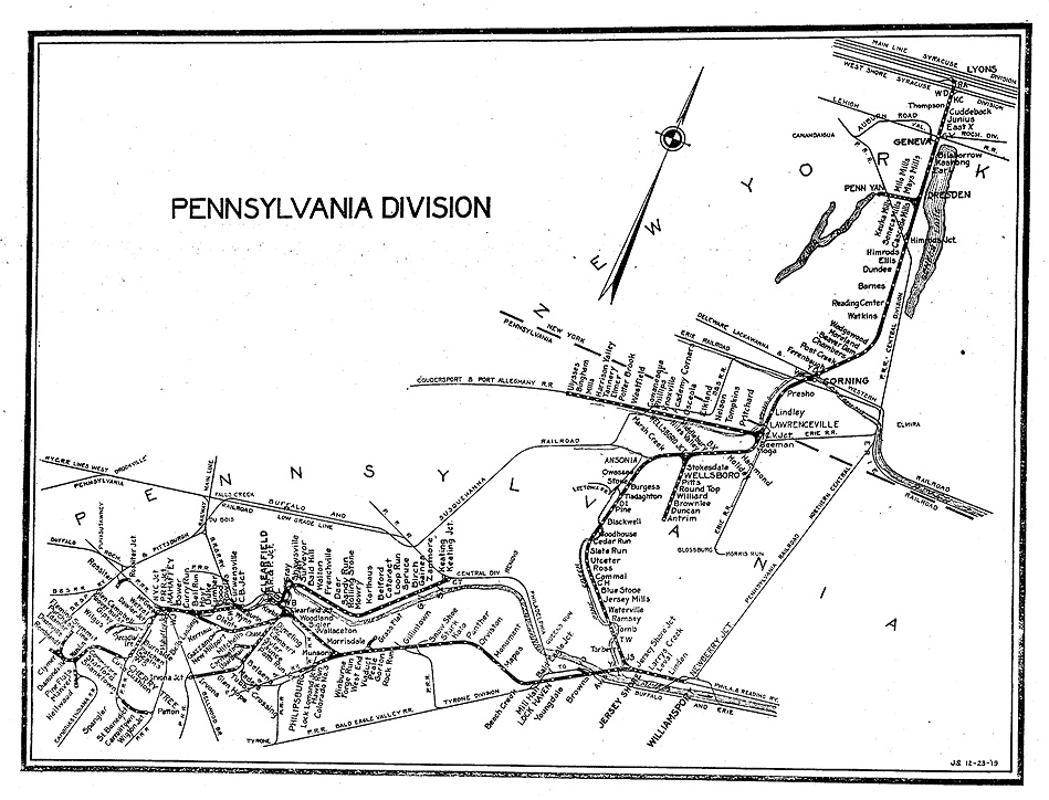
New York Central Pennsylvania Division Map dated December 23, 1919. The Beech Creek District consisted of the trackage from Jersey Shore Jct. southward and westward. The balance of the trackage, from Newberry Jct. (near Williamsport) to Jersey Shore Jct. and northward into New York State was the Fall Brook District. Coal from the Clearfield District, for which the Peale area was a part, moved to Newberry where it was interchanged with the Reading Railroad for forwarding to tidewater, or continued northward into New York for other coal users in the East. The output of the Clearfield Bituminous Coal Corporation mines was used for company supply coal by the NYC's Lines East (of Buffalo). Click on image (or here) for full size image.
The New York Central, successor to the New York Central & Hudson River Railroad, continued to lease the Beech Creek for decades to come. Not until May, 1948 did the NYC move to acquire control of the Beech Creek through stock ownership. Despite the NYC's control of as much as 79 per cent of the Beech Creek's stock, the lease relationship continued.
The New York Central merged with its arch rival, the Pennsylvania Railroad Company, in 1968 to form the Penn Central. Just two years later the PC declared bankruptcy paving the way for the arrival of Consolidated Rail Corporation (Conrail) in 1976. Conrail would be the last entity to provide rail service in the Peale area.
Conrail operated the last train through the Peale area in 1993, a move from Clearfield to J. H. France Refractories in Snow Shoe and return. By this time J. H. France was the sole remaining customer on the branch as the railroad�s two remaining coal customers in the Snow Shoe area ceased loading trains a few years prior. Note: The line from Snow Shoe to Bald Eagle Junction, near Mill Hall, was removed in 1966-68.
Track removal by a Conrail contractor, A & K Railroad Materials, Inc. of Utah, began in December 1993 at Snow Shoe. They worked west as far as Gorton before the harsh winter forced a temporary halt to the project. Once the weather broke track removal continued through Peale and Viaduct to a point just east of Winburne and was completed by mid-1994.
As the track was being taken up in the Peale area, Headwaters Charitable Trust, a sister organization of Headwaters Resource Conservation & Development, acquired the right-of-way from Conrail in hopes of developing a rail-to-trail project. The Snow Shoe Trail Association has since been formed. Hopefully this group will be able to preserve this historic right-of-way.
The Beech Creek Railroad: A Tour of the Route Today
Now that you have an overall historical framework for the Beech Creek Railroad in relation to Peale, let's take a tour of the line in the Peale area, from Gorton to Viaduct. This area has a great deal to offer to the historian, railroad enthusiast and industrial archaeologist. Included in this section will be historical references to the specific area discussed above. Note: unless otherwise indicated, timetable, not geographical directions, are used in the following descriptions. Keep in mind that in the railroad timetable, the rail line between Gorton and Viaduct runs east to west. Also, milepost (MP) references will be included. The distance in all cases will be from Jersey Shore Junction, Lycoming County, the origin of the Beech Creek Railroad.
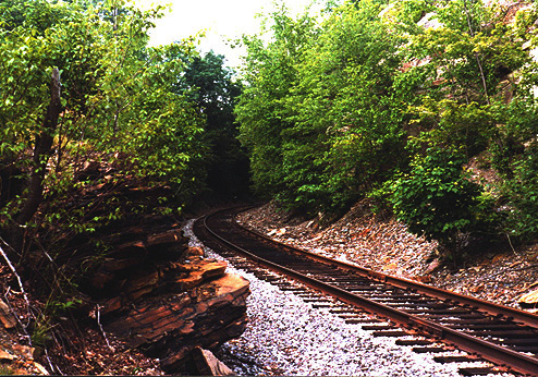
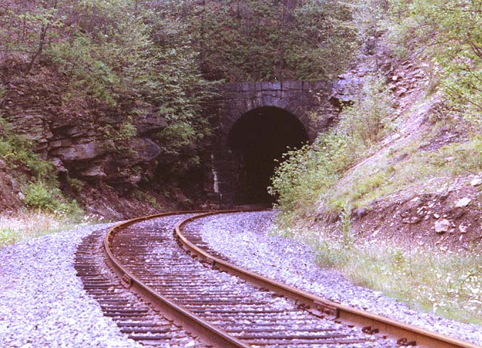
Beech Creek RR, rock cut. This July 15, 1984 view looking east in the section between the Peale Tunnel and Gorton is typical of the Beech Creek Railroad in the Gorton-Peale-Viaduct area: multiple curves and rock cuts. Photo by Jeff Feldmeier. Click on image (or here) for full size image.
The trackage in this section is characterized by significant grades, sharp curves and numerous rock cuts. In the less than five mile section between Viaduct (elevation 1373 feet) and Gorton (elevation 1576 feet) the line climbs 203 feet. The grade from Viaduct to about the Peale station (elevation 1440 feet) is 0.83%. From Peale to the west end of Peale Tunnel the grade increases to 1.2%. Through Peale Tunnel itself the grade is 0.75% and then increases to 0.89% from the east portal for the next half mile or so before lessening to 0.79% to about the current township road crossing at Gorton.
In terms of curves the sharpest in this section is a 10 degree affair just east of the bridge at Viaduct and another immediately west of MP 59. There is also a 9 degree, 30 foot curve right at the Peale station. In addition there are no less than nine 8 degree curves in the Gorton to Peale Tunnel section alone. As a means of comparison, the sharpest portion of the famous Horseshoe Curve on the Norfolk Southern main line west of Altoona, Pennsylvania, is just over 9 degrees.
Due to the grades, sharp curves and heavy tonnage coal trains, the trackage in the Gorton-Peale-Viaduct area was a helper district during most of the steam era. A locomotive or two (depending on the train's tonnage) would be placed on the rear of eastbound trains at Viaduct. Westbound trains could also see helpers, placed on the head end at (the village of) Beech Creek and operated to Viaduct where they would be switched to the rear of the train before continuing west. Helpers were used until at least the early 1930's when larger locomotives and stokers (mechanism to draw coal from the tender to the firebox mechanically as opposed to by hand by the fireman) were employed.
Gorton is located 55 miles west of Jersey Shore Junction or three miles west of Peale station (MP 55 is located at the current township road crossing). Gorton was named after Alonzo H. Gorton, a descendent of one of the Corning, New York area's pioneer settler families. Alonzo became a foreman of car building at the Fall Brook Railroad's shops at Corning and later became the superintendent of the Blossburg & Corning Railroad. The Fall Brook and Blossburg & Corning, like the Beech Creek, were affiliated with the New York Central. Around the year 1900, Gorton had 30-40 houses and 25-30 pupils at its school.
Coke ovens, at approximately MP 54.7, operated by the Clearfield Bituminous Coal Company, gave rise to the settlement of Gorton Heights, as it was originally known. Upwards of 250 such ovens were located on the south side of the track just east of the present township road crossing at Gorton. Red earth marks the site today. The stone remains of the coke ovens were used in a Gorton area hunting camp as well as a tavern and home near Grassflat.
At Gorton a major derailment took place on February 8, 1900. In this incident three railroaders lost their lives and several were hurt. Both engines involved derailed and 22 cars were destroyed. The Centre Democrat of February 15, 1900 reported that railroad cars were piled 30 feet high!
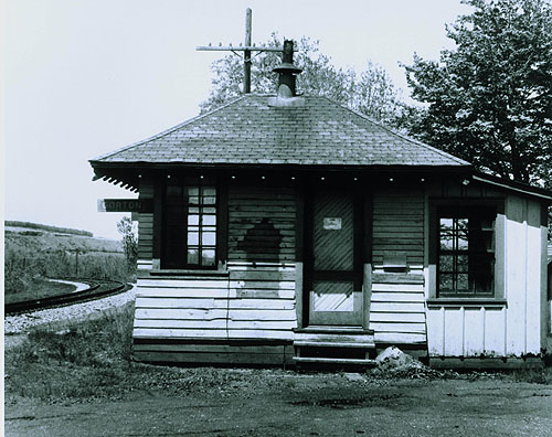
Gorton station, looking west. This photo originally appeared in the Centre Daily Times, April 28, 1960. At the left background one can see a small portion of the Robert Bailey coal stripping operation at the Tunnel Mines site. Photo courtesy of the Penn State Room, Patee Library, Penn State University. Click on image (or here) for full size image.
Gorton station and a few other railroad structures (section house, bunk house, barn, and some smaller structures) stood on the north side of the track at MP 55.25. The station was located within a wye track from which a short branch extended northward, probably to a coal tipple. The Gorton station had telegraph call letters "GO" in November, 1902 but by 1910 they had been changed to simply "G" which was carried until about 1925 when this station ceased to have an operator. An operator controlled the semaphore signal located at each station on the Beech Creek line and also, in conjunction with the train dispatcher (located at Jersey Shore Jct. until the early 1960's) issued train orders to trains operating on the line. According to timetables, Gorton was open around the clock from November, 1902 to at least 1910. By November, 1912 Gorton's hours were reduced to a day office only. By June, 1925 and beyond, Gorton had no operator. For almost the first two decades of passenger service, Gorton appears to have been a regular stop, however by November, 1902 it had been downgraded to a flag stop (a passenger desiring to be picked up would place a white flag on the station to signal the train to stop) . Following the cessation of passenger service on the line, the Gorton station was used by the Maintenance of Way Department for storage. Frustrated with continued break ins, the NYC decided to demolish the station about 1965.
Almost immediately across the main track from the Gorton station were the eastern connections to a few spurs that served a coal tipple last operated by Robert Bailey Company. The western connection to the main was at MP 55.72 so these sidings were almost half a mile long. Bailey ceased operations here probably in the late 1960's. Some remains of this operation, including the tipple, are visible today.
Continuing west, at about MP 55.64 was the connection with the Tunnel Mines Branches. This network of branches (Tunnel Mines Branch No. 1 & 2, 3 and 4) extended south of the main track and looped around to serve four of the five drifts operated by the CBC as described above. Many Peale residents were employed at these mines. Keep in mind that these drifts were at least three miles, as the crow flies, from Peale - workers would have to walk this distance to and from work. The Tunnel Mines apparently never reached their potential and this is one of the key reasons for the Village of Peale's early demise. Nonetheless a significant enough amount of coal was left behind as this area was strip mined in more recent decades, probably by Robert Bailey. Due to this stripping, the remains of the Tunnel Mines and the Tunnel Mine Branches' grades are few or nonexistent.
Also at the Tunnel Mines Branches connection, the main line crossed from Snow Shoe Township into Rush Township, going westward. Both of these townships are in Centre County. The railroad would first enter Clearfield County at the mid point of the bridge at Viaduct.
A track watchman's shanty was located at about MP 56.7. Such shanties were somewhat common along the mountainous, forested and thinly populated Gorton to Viaduct section so as to keep an eye open for potential slides, washouts and other dangerous conditions on the railroad.
Continuing west toward Peale one reached a short branch at about Milepost 57.1. This branch extended south from the main and served a few coal tipples probably operated by Isaac Heaton, a small coal operator who leased coal properties from the CBC in the 1920s and 30s. This line was probably originally built to serve Tunnel Mines Drift No. 5. A few houses were located around these tipples, the settlement appropriately being known as Tunnel Side due to its close proximity to the Peale Tunnel.
Just around the curve from this last spur one reaches the east portal of Peale Tunnel, MP 57.23. The tunnel, also known as the Moshannon Tunnel, has cut stone portals at each end. The cut stone continues into the interior at each end before giving way to natural rock walls and a ceiling of brick or brick with concrete cap. During World War I a guard was posted at the tunnel to prevent potential saboteurs from entering the structure.
Peale Tunnel, looking westward on July 20, 1981. Photo by Jeff Feldmeier. Click on image (or here) for full size image.
Upon exiting the Peale Tunnel westbound at MP 57.47, and then a nearby track watchman's shanty, the next location of significance was Peale station, MP 58.01. The Peale station, located on appropriately named Station Hill, was quite distant from the village itself, about a mile as the crow flies, to the geographical southeast of the village. In fact, the station was located in Centre County while the village was located well below, across the Moshannon Creek, and in Clearfield County. This would be as close to Peale as the Beech Creek main line would come. Although the main line track bypassed Peale, the village was probably located as such because it was equidistant between the Tunnel Mines and Grassflat, mines for which opened at close to the same point in time. When the Tunnel Mines were closed, coal mining production at the CBC's Peale Field was concentrated at Grassflat, causing much of the Peale population to move closer to the drifts at that village immediately west of Peale.
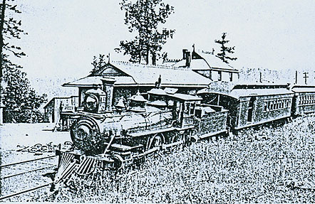
Peale Station. A westbound passenger train stops at the Peale station in 1892. This photo is from a rather unlikely periodical: The Explosives Engineer of March/April, 1944.
)
Peale Station. Submitted by Genevieve Johnson, who was born and lived in Peale until the late 1930s. Genevieve resides in Grassflat, PA.
The Peale station building itself was located on the north side of the track and
just east of the current township road crossing. The passenger waiting room and
operator portion of the station was a two story affair with the upper floor
probably for living quarters of the stationmaster or caretaker. A single story
freight station was attached on the west side. A short siding ran in front of
the station. Peale station had the telegraph call "CD" according to timetables
from November, 1902 and 1910. No office calls were indicated beyond 1910.
According to the November, 1902 and 1910 timetables, an operator was on duty at
Peale on a daily basis. By as early as November, 1912 and beyond Peale had no
operator on hand. Following the removal of the operator the NYC had a caretaker
agreement in place to assist passengers and help maintain the station. The
caretaker lived at the station and was paid by the railroad on a monthly basis
and had oil for lights and coal for the stove provided by the railroad. Peale
was a regular passenger train stop until 1923 or 1924 when it was downgraded to a
flag stop. The station was sold, probably by the mid 1930s, and removed by the
Zetts Family for its lumber. The Zetts Family has operated a fish hatchery in
Drifting for many years.
Passenger service was operated on the line through Peale from the mid 1880's until sometime prior to April, 1934 on a daily, except Sunday, basis. A February 2, 1885 timetable lists a westbound, train No. 2, arriving at 8:46 a.m. and another westbound, No. 4, arriving at 12:46 p.m. An eastbound, No. 1 arrived at 7:12 a.m. and another eastbound, No. 3 at 10:07 a.m. By 1888 until about the turn of the century a westbound would arrive at Peale in the mid to late morning and another westbound in the early evening. An eastbound would stop at Peale in the early to mid morning and another in the early to mid evening. By August, 1894 westbound train Nos. 33 and 37 and eastbound Nos. 30 and 36 appeared in the timetables. These train numbers would be a constant until almost the end of passenger service in the mid 1930's. Beginning about 1901 these four trains' schedules became fairly consistent over the next few decades. #33 was scheduled to arrive at Peale around 10 a.m. and would do so until passenger service ceased about 1934. #37 would arrive at Peale in the 5:00/5:30 p.m. timeframe until about 1923 where it was scheduled to arrive about an hour earlier. This train, along with No. 30, were dropped by April 26, 1931. For the eastbounds, #30, beginning by 1901, would arrive at Peale in the 9:30/9:45 timeframe. By June 28, 1914 this train's schedule was revised to a late morning arrival at Peale. This schedule would remain relatively the same, until this train was dropped by April 26, 1931. Finally, train No. 36 by 1901 and up to about 1930 was scheduled for a 6:30 p.m. arrival until April 26, 1931 when the arrival was changed to 1:00 p.m. Until some time after April, 1929 passenger service was provided by a 4-4-0 type American locomotive. After this time the train was replaced by a gas-electric self-propelled unit, commonly known as a "doodlebug." Passengers arriving at Peale could take the stage into Peale, Grassflat or Drifting. For well after Peale ceased to be as a thriving village, the Peale station was where the U.S. Mail for Grassflat (and possibly other local communities) was picked up from the train for delivery via the stage. A sleigh filled in for the stage during the snowy months.
Located kitty-corner from the station building was a trackmen's bunk house. After the railroad sold this structure it became a hunting camp, called the " '76 Camp." This structure burned to the ground in a fire of suspicious origin in 1997.
Across the track from the bunk house and slightly down the hill, was a clay tipple operated by General Refractories. The Peale area, like much of Central and Western Pennsylvania, is rich in refractory clays. The "Clay Siding," as it was known and for which connected with the main at MP 58.16, was in place by at least late 1925 and was in operation until the 1960's. The remains of this tipple are very much intact today.
From Peale to Viaduct the track roughly parallels Moshannon Creek, well below in the valley, with a lot of side hill running and frequent rock cuts. Due to the potential dangers of slides, washouts and the difficult operating territory, a few track watchman's shanties were installed in this section (near MP 58.7 and MP 59.2) to watch for trouble spots. At MP59 a Maintenance of Way Department's nightmare presented itself at the appropriately named "sinkhole." Here the railroad over many decades had to contend with slide conditions. Extra ballast was often required (even into Conrail days) and pilings along the north side of the track were a must. The pilings are extant today.
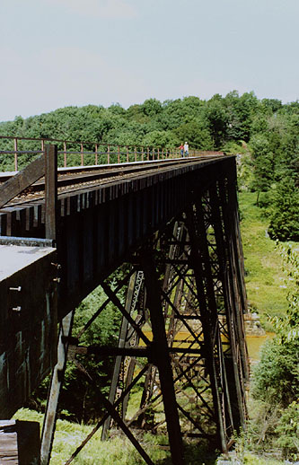
The large trestle at Viaduct, looking eastward on August 25, 1984. Photo by Fred Feldmeier. Click on image (or here) for full size image.
The large trestle over the Moshannon Creek, east end for which is at about MP 59.6, is what obviously gave the one-time railroad facility on the west end of the bridge its name - Viaduct. A trackman's or bridge watchman's shanty was located at the bridge's east end. The center of the bridge is also the Centre/Clearfield County line (the Moshannon Creek serves as the county line in this section). Upon entering Clearfield County here one reaches Cooper Township. The original bridge was made of iron and wood. Today, at the bottom of the bridge, a pedestal or two without an attached steel bridge tower, were probably a part of this original bridge. The current bridge, rebuilt in 1902-03, is over 770 feet long and 110 feet above the creek below. The bridge, built by American Bridge Company and installed by a contractor, consists of 15 spans supported by eight towers, all made of steel. Until 1984, the decking of this bridge was made entirely of wood, with walkways on both sides. At two locations along the walkway were appendages to hold a large barrel of water to be used in the event sparks from a train set the ties or walkways of the bridge on fire. Local lore has stories of daredevils attempting to cross the bridge by walking and balancing atop the railings, even blindfolded. By the early 1980s the wooden walkways had deteriorated to the point of being unsafe and they were removed, the west side (only) walkway being replaced with the current galvanized walkway and metal railing.
)
Viaduct Tower. Submitted by Vera (Josephson) Edgren whose mother Martha (Dinges) Josephson was born and lived in Peale until her marriage in 1926. Martha lived in one of the surviving buildings in Peale).
At the west end of the bridge is the site of the one time locomotive servicing
facility and yard of Viaduct. Viaduct served as the base for helper engines
operating eastward (as described above) as well as to Van, the divide between the
Moshannon Creek and West Branch of the Susquehanna River, just east of
Wallaceton. In addition, locomotives for several of the mine runs (Grassflat,
Winburne, Hawk Run and Philipsburg areas) were based at Viaduct. Structures
present during the steam era at Viaduct included the following: telegraph
office/station, coal dock and trestle, water tower and water plugs, engine house,
sand house, oil house, tool house, store house, car repair and oil house, ice
house and a bunk house and mess hall. In addition there were at least a few
houses which served as employees' residences, and two pump houses on Browns Run.
Most of these facilities were removed circa 1953, following the arrival of diesel-electric motive power and the continued consolidation of locomotive servicing facilities into large facilities at places like Clearfield and Avis, Pennsylvania. Probably the last two remaining structures at Viaduct were the telegraph office/station, located almost adjacent to the bridge, and a Maintenance of Way shanty part way out the Grassflat Branch.
Connected with the steam locomotive facilities at Viaduct was a wooden water pipe bridge that crossed the Moshannon Creek between the current Interstate 80 bridges over the Moshannon and the railroad bridge. This pipeline ran from a reservoir at the head of Laurel Run (since destroyed by the highway construction) down the mountain to the Moshannon, across the pipe bridge, and up the opposite hillside to Viaduct. This bridge was a fire victim in the late 1960s (again a fire of suspicious origin) and today, only the two concrete pillars remain. The Laural Run reservoir was in addition to the Browns Run water supply, pump houses for which are noted above.
The above mentioned telegraph office/station carried the telegraph office call "FC" from at least the turn of the century to about 1953, except for a period from about 1934-1943 when it had none. By at least the early years of the 20th century until about 1912, this office was manned around the clock. Through the teens, this station was open at least 12 hours per day before returning to around the clock operation for much of the 1920s. During the depression Viaduct lost its operator until some point during World War II. From then until at least 1951 the office was again opened for 12 hours per day. By 1953 Viaduct was open 8 hours per day and by 1957 was closed for good. During the passenger train era Viaduct was always a regular stop, never having been downgraded to flag stop status like Gorton and Peale. Most of the passengers arriving and departing Viaduct were probably railroad employees and certainly the "railroad mail" was dropped off here along with the payroll, probably for both railroad employees as well as CBC employees in the Peale Field.
In the late 1920's, yard facilities at Viaduct consisted of sidings capable of handling 215 cars (based on a 43 foot car length). As late as April, 1953 this capacity was still at a sizeable 189 cars (based on 44 foot cars).
Connecting at Viaduct was a branch that ran out to Grassflat. On the 1883 Peale Village Plan one notices a rail line entering from the west. This track could not have branched off the main line at the Peale station area due to the topography. More likely it originated at Viaduct, ran toward Grassflat, and then was to be extended into Peale proper. Two more reasons why this line probably was to have originated at Viaduct: (1) Viaduct's original name was Peale Junction and (2) the original name of the Grassflat Branch was the Peale Branch. The line into Peale proper was never built, having only reached the northwest corner of what would become Grassflat. Thus, a standard gauge steam road rail line never reached into Peale itself.
The Grassflat Branch, which ultimately reached almost ten miles in length after all its looping around the hills to minimize grades, served coal tipples at Knox Run, Grassflat Mines (or Cooper No. 1), Pleasant Hill, Moravian and Cooper No. 2. All of these mines were originally operated by the Clearfield Bituminous Coal Corporation (the Clearfield Bituminous Coal Company was reorganized as the Clearfield Bituminous Coal Corporation at Peale on October 7, 1886. Peale would serve as the CBC's headquarters until 1900 when the headquarters was moved to Clearfield). Knox Run would later be leased by Peale, Peacock & Kerr (the "Peale" being Rembrandt Peale, the son of S. R. Peale for which the Village of Peale received its name) and Moravian by the Moravian Coal Company. The tipple at Grassflat Mines would later be used by Robert Bailey Company (the same Bailey who also loaded at Gorton) after the CBC ceased active mining operations at Grassflat in 1945. Bailey loaded trains at the Grassflat tipple until about the late 1960's. Following that the remains of the Grassflat Branch, by now reduced to only 2.9 miles, was simply used for car storage or was left to rust.
What is the future of the old Beech Creek line through the Peale area? Although trains no longer operated via this historic right-of-way, the grade is likely to be preserved by the Snow Shoe Trail Association, a local rails-to-trails group. This group in mid 1999 received grants of $390,000 from the federal government plus another $65,000 from the Pennsylvania Department of Conservation and Resources. These monies are to be used to repair and make safe the various structures on the trail, particularly the Peale Tunnel and bridge at Viaduct. Hopefully the success of the trail will help preserve the area's railroad and mining history for future generations.
References
Various articles from the Clearfield Republican.
Various Beech Creek Railroad and New York Central Pennsylvania Division
timetables.
Various New York Central/Beech Creek Railroad valuation maps.
1970 Penn Central Williamsport Division Track Chart.
Scott, George A., Clearfield Today and Tomorrow: Railroads of the Area, 1968.
d'Invilliers, E. V., Second Geological Survey of Pennsylvania, Report of Progress
T4, The Geology of Centre County, published by The Board of Commissioners for the
Second Geological Survey, 1884.
Personal letters from Janie French of Headwaters Resource Conservation &
Development.
Chambers, Cordes III, "The Mountaintop" thru Newspaper Accounts, 1900-1910,
Volume 1.
Personal e-mails from Roger Mayhew.
Remembrances of Steve Sicora, Sr.
"Headwaters Inspection Report...," Snow Shoe Trail structures study prepared by
Sweetland Engineering and Associates, Inc., State College, Pa., for Headwaters
Council.
In addition to those mentioned above, the author would like to thank the
following for their assistance in making this article a reality: Ray Lyncha, Todd
Willoughby, the late John Butler, Bill Reddy, Luther Gette, Frank Mellott, Mark
Eyer and my wife, Laural Feldmeier.
Questions, comments, or additional information? Contact Jeff Feldmeier at
BeechCrRR@aol.com
Please contact j.b. krygier
(jbkrygie@cc.owu.edu) with comments, input, or additional
information.
Contents...
Introduction: The Ghost Company Town of Peale, Pennsylvania
Interpreting the Geographies of Peale
>>>The Beech Creek Railroad in the Peale, Pennsylvania Area
Peale Pennsylvania Manuscript Census
Project Peale: A Guerrilla Art Project
Historical Information about Peale and the Tunnel Mines
Kyle Crichton: Peale's Most Famous Son?
Directions to Peale, Pennsylvania
E-mail: jbkrygie@cc.owu.edu These pages comprise an ongoing project to document,
map, interpret, and memorialize the ghost company town of Peale
Pennsyvania located along the Clearfield and Centre County (PA) boundaries in
north-central Pennsyvlania.
These pages comprise an ongoing project to document,
map, interpret, and memorialize the ghost company town of Peale
Pennsyvania located along the Clearfield and Centre County (PA) boundaries in
north-central Pennsyvlania.