Geography 222 The Power of Maps
...to Geog 222 Main Page and Course Description
...to Geog 222 Syllabus
...to Geog 222 Course Schedule and Lecture Outlines
...to Geog 222 Laboratory Information and Student Projects
Geog 222 Lecture Outline: Map Coordinate Systems
Update: 10/21/18
Map Locational or Coordinate Systems
Modern maps (except informal sketch maps and mental maps) are based on systematic location
encompassing the entire earth (or parts of it).
- Delaware, Ohio is at 40 degrees, 18 min North Latitude, 83 degrees 4 min West Longitude
But in the past...lack of an all encompassing system of locations:
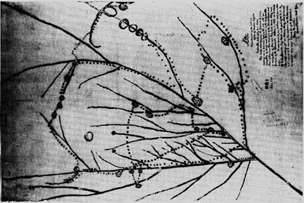
- Native American (Iowa) map of Upper Mississippi River Region
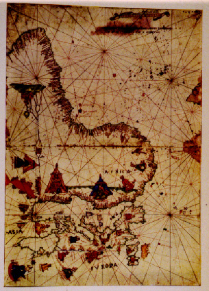
- Rhumb lines (path of a path of constant compass bearing) on Italian Navigation Map: ca 1500
- how does how we think about the world relate to an all encompassing system of locations?
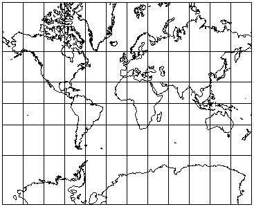
- Post 1500: view of the world shifting from pieces to a contained framework, into which everything fits
Map Locational or Coordinate Systems
- provide a way to locate features on the earth and in GIS and computer mapping
- they often result in coordinates: a pair of numbers specifying location
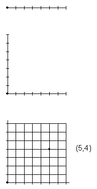
- basis of these coordinate systems >>> the idea of the graph
Four main characteristics that differentiate these coordinate systems:
1. What feature forms are the coordinate system generally used to specify?
2. What kind of geometry does the coordinate system use?
- planar: assume a flat earth
- advantage: easy mathematics
- disadvantage: increase in distortion as area covered increases
- spherical: assume a spherical earth
- advantage: minimal distortion; takes into account spherical shape of earth
- disadvantage: more difficult mathematics
3. How much area does a coordinate system cover?
- local, state/province/region, part of globe, entire globe
4. What are the units of measurement used?
Discuss these four characteristics in the context of five different map coordinate systems
Coordinate systems primarily used to locate POINTS
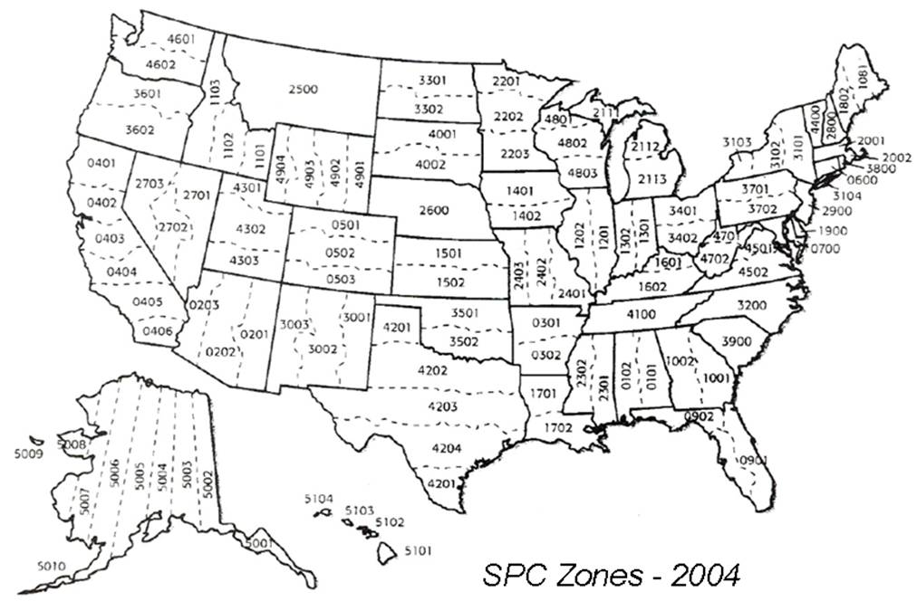
1. State Plane Coordinate System (SPCS)
- geometry: planar (in title)
- coverage: U.S. states, or parts of states (in title)
- units: english (U.S. system)
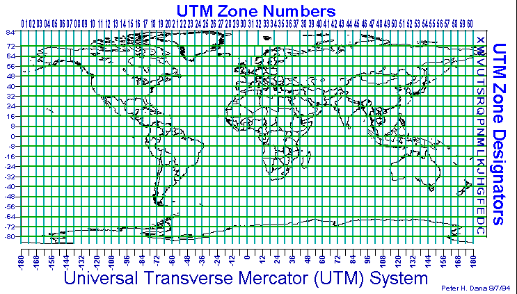
2. Universal Transverse Mercator System (UTM)
- geometry: planar
- coverage: narrow strips from pole to pole around the globe
- units: metric
3. Latitude/Longitude
- geometry: spherical
- coverage: global
- units: degrees/minutes/seconds
Coordinate systems primarily used to locate AREAS
4. U.S. Public Land Survey System (USPLS)
- geometry: planar
- coverage: state-sized areas in middle and western U.S.
- units: english
5. Arbitrary Reference Grids
- geometry: planar
- coverage: local to global
- units: various
Review each of these and detail...
- How the coordinate system is defined
- Who uses the coordinate system and what they use it for
- How the coordinate system is represented on maps
Example Maps:
- Delaware Ohio 1:24,000 topo quad
- Carter Montana 1:24,000 topo quad
- Donaldsonville Louisiana 1:24,000 topo quad
- Scott City, Kansas 1:62,500 topo quad
Coordinate Systems primarily used to locate POINTS
1. State Plane Coordinate System (SPCS)
History:
Defining SPCS: US map with zones
Coverage: 120 zones in US only running primarily east/west or north/south
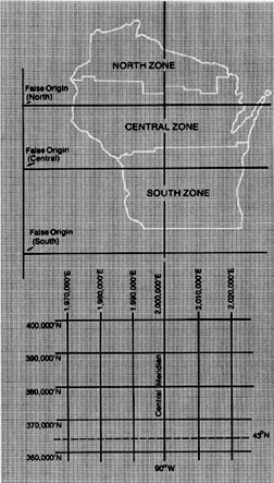
- Ohio map with zones / graph
Geometry: Planar
- each zone has a grid/graph imposed over it
- false origin located outside of the zone to the south and west (0,0)
- 2,000,000 feet west of central meridian
- only positive values used in SPCS
- locations are measured in FEET from this origin - read like a graph
- feet east called "eastings" then feet north called "northings"
Who uses SPCS and for what?
How is SPCS shown on a USGS Topo Sheet
PROP) Delaware OH 1:24,000 quad: lower left, near township name "Concord"
- Black tic outside of map neatline
This point is located as such:
- 1,830,000 feet E, 220,000 feet N, OH, N
2. Universal Transverse Mercator System (UTM)
History:
Defining UTM
Coverage: 60 strips (zones) around entire globe oriented north/south and numbered
west to east from the international date line
Each strip...
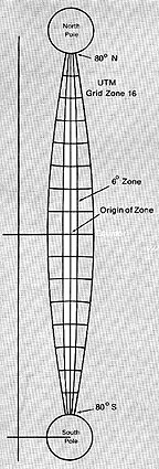
- is 6 degrees wide (i.e., 6 degrees of longitude)
- has 2 false origins (one for the north half; one for the south half) located as
with the State Plane Coordinate System to the S and W of the zone at (0,0).
- only positive values used in SPCS
- 500,000 meters west in North; 500,000 m west / 10,000,000 meters south in South
- locations are measured in METERS from this origin - read like a graph
- meters east then meters north
Geometry: Planar
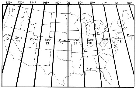
- UTM Zones in US
- Ohio in zones 16 (90 degrees to 84 degrees) and 17 (84 degrees to 78 degrees)
Who uses UTM and for what?
How is UTM shown on a USGS Topo Sheet?
PROP) Delaware OH 1:24,000 quad: lower left, near township name "Concord"
- blue tic outside of map neatline
- have to add "000" to numbers on map
This point is located as such:
- 320,000 mE, 4,458,000 mN, Zone 17, N
3. Latitude/Longitude
History:
- Eratosthenes: Greek, 3rd century BC: proposed a system of latitude and longitude for the Earth.
- Hipparchus: Greek, 2nd century BC: using Lat/Long to specify locations on the Earth; determining
longitude by comparing the local time of a place with an absolute time.
- Al-Biruni (Persian, 11th century) proposed that the earth rotated on its axis, forming our modern
notion of how time and longitude are related.
- Latitude: from the altitude of the sun at noon with the aid of a table giving the sun's
declination for the day.
- Longitude: Earth rotates at a rate of 360 degrees per day, or 15 degrees per hour, there is a direct relationship
between time and longitude. If the navigator knew the time at a fixed reference point when some
event occurred at the ship's location, the difference between the reference time and the
apparent local time would give the ship's position relative to the fixed location. Finding
apparent local time is relatively easy. The problem, ultimately, was how to determine the
time at a distant reference point while on a ship.
Defining Longitude
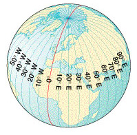

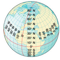
- Also called meridians
- Meridians run N and S
- and measure 180 degrees E and 180 degrees W around the globe
- 60 minutes = 1 degree
- 60 seconds = 1 minute
- 10 degrees, 20 minutes, and 30 seconds E Longitude (10o 20' 30" E. Longitude)
- meridians always pass through both poles
Four important characteristics of longitude and meridians
1. All meridians are great circles which pass through both poles: slice the sphere
in half; shortest distance between two points on the globe
2. Prime meridian arbitrary 0 degree base line meridian (Greenwich England)
- longitude measured (from 0 degrees to 180 degrees) E or W of Greenwich
3. Meridians converge at the poles
- one degree of longitude at the equator = 69 miles
- one degree of longitude at the poles = 0 miles (a point)
USGS Topo Quads are defined (in area covered) by longitude (width) and latitude (highth)
PROP) Delaware OH 1:24,000 Quad: At all corners of sheet
4. Longitude is measured by the time difference between greenwich and the point of
interest.
Defining Latitude
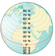
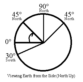
- Also called parallels (parallel to each other)
- Parallels run East and West and measure 90 degrees N and 90 degrees S of the equator
Four points about latitude and parallels:
1. Only the equator is a great circle; all other parallels are not
2. Equator is the base line (0 degrees) for latitude
- latitude measured (from 0 degrees to 90 degrees) N or S of equator
3. Parallels never converge
- one degree of latitude always = 69 miles
- USGS Topo Quads are defined by longitude (width) and latitude (highth)
- PROP) Carter MT 1:24,000 Topo vs Donaldsonville LA 1:24,000
- since parallels never converge and parallels define the highth of a topo
sheet the highth of a USGS topo sheet is always the same
- since meridians do converge and meridians define the width of a topo
sheet the width of a USGS topo sheet varies (wider in south, narrow in N)
4. Latitude is measured
- by the angle between the horizon and the north star in the northern
hemisphere
- by the angle between the horizon and the southern cross in the southern
hemisphere
...In general, lat/long
- coverage: entire globe
- geometry: spherical
- the latitude/longitude coordinate system
- has an origin of (0 degrees, 0 degrees) and all other locations are specified in
degrees, minutes (60 minutes = 1 degree) and seconds (60 seconds = 1 minute)
Who uses Lat/Long and for what?
How is Lat/Long shown on a USGS Topo Sheet
PROP) Delaware OH 1:24,000 Topo: Lat/Long crosshair: S of Radio Tower, near "W" in Delaware
PROP) Delaware OH 1:24,000 quad: lower left corner
- corners; black tics on inside of neatline
This point is located as such:
- 83 degrees 7 minutes 30 seconds W, 40 degrees 15 minutes N
Coordinate Systems primarily used to locate AREAS
4. U.S. Public Land Survey System (USPLS)
History: Metes and Bounds
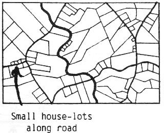
- PROP) French Long Lots: Donaldsonville LA 1:24,000 topo
- Land Ordinance of 1785: origin of U.S. Public Land Survey System
Defining USPLS
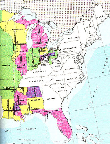
- Eastern US map with USPLS Survey Zones
- Coverage: chunks of land primarily defined as they became available for
settlement; thus the patchwork pattern
- Each area has
- an arbitrary base-line running E/W
- an arbitrary prime meridian running N/S
Township and Range System
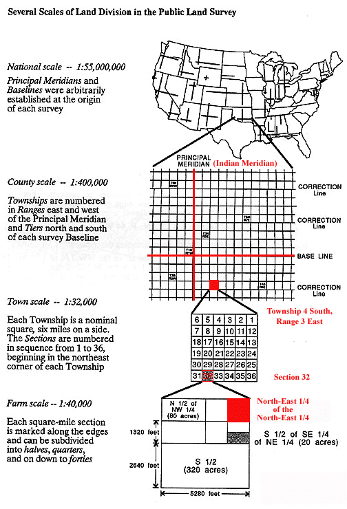
- Township lines are placed every 6 miles north and south of the base line
- Range lines are placed every 6 miles east and west of the prime meridian
- The system creates 6 mile by 6 mile squares called townships
- Within each township are 36 sections numbered from 1 to 36
- boustrophedonic: "as the ox plows"
- each section can be further divided into smaller and smaller parcels
Geometry: Planar
Who uses USPLS and for what?
How is USPLS shown on a USGS Topo Sheet
- PROP) order on the land: Scott City, Kansas 1:62360 Topo Quad
- Hines School: area is located as such:
- NW1/4, Section 15, Township 20 South, Range 32 W, 6th PM
5. Arbitrary Reference Grids
Can be just about any kind of reference system that is set up for a specific
map and is not connected in any way with any other map
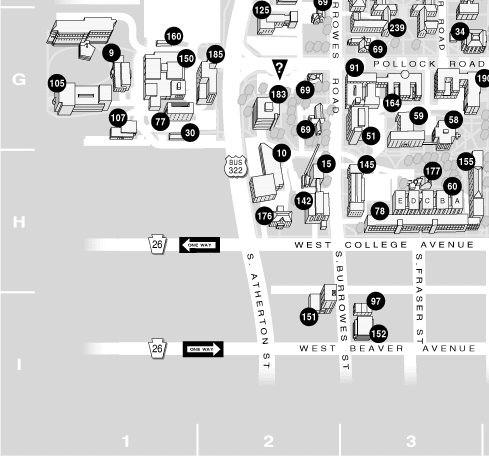
- Campus map with Arbitrary Grid System
Summary: Map Coordinate Systems
Four important aspects of map coordinate systems
- What feature forms are the coordinate system generally used to specify?
- What kind of geometry does the coordinate system use?
- How much area does a coordinate system cover?
- What are the units of measurement used?
...and five important systems...
- State Plane Coordinate System (SPCS)
- Universal Transverse Mercator System (UTM)
- Latitude/Longitude
- U.S. Public Land Survey System (USPLS)
- Arbitrary Reference Grids
E-mail: jbkrygier@owu.edu
...to Geog 222 Main Page and Course Description
...to krygier teaching page.
...to krygier top page.
OWU Home
OWU Geology and Geography Home
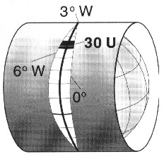 UTM Zone on Globe (left) and Rectangular Map (below)