Geography 222 The Power of Maps
...to Geog 222 Main Page and Course Description
...to Geog 222 Syllabus
...to Geog 222 Course Schedule and Lecture Outlines
...to Geog 222 Laboratory Information and Student Projects
Geog 222 Lecture Outline: Geographic Data and Data Sources
Update: 9/28/18
Introduction
The gathering of data is a vital step in the map making process
The procedures followed will strongly influence the resulting map:
- what we are mapping is not the environment
- but data which represents the environment
Several important issues in the data gathering process
- 1. Phenomena and Data: Individual & Aggregate, Continuous & Discrete
- 2. Creating & Geting Data
- 3. Data Organization
- 4. Transforming Data
- 5. Time & Data
- 6. Data Accuracy
- 7. Digital Data
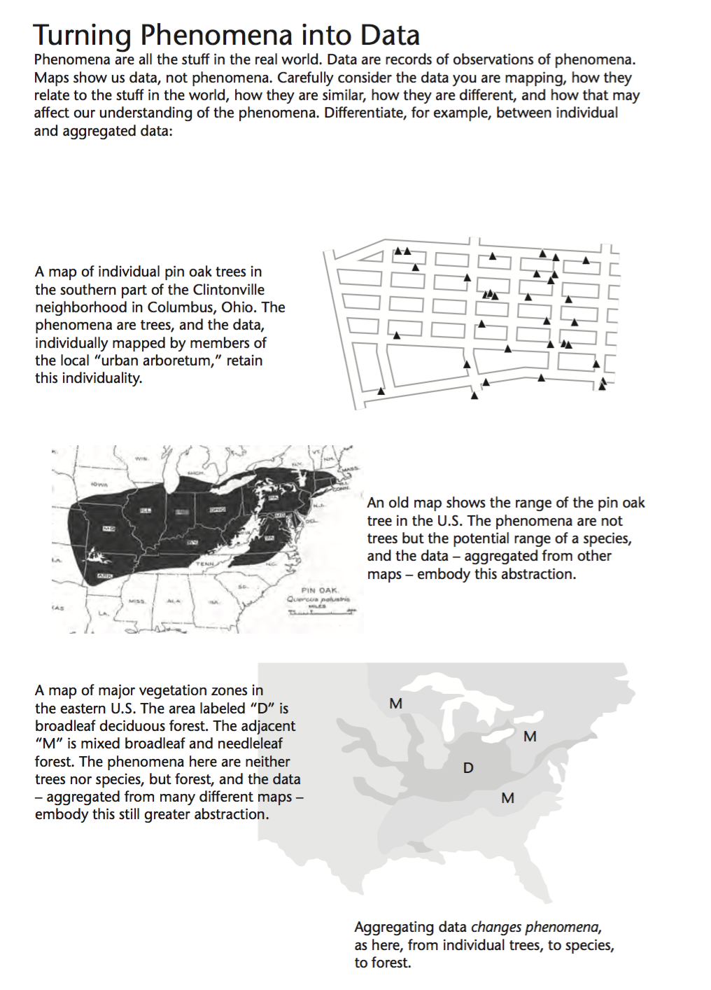
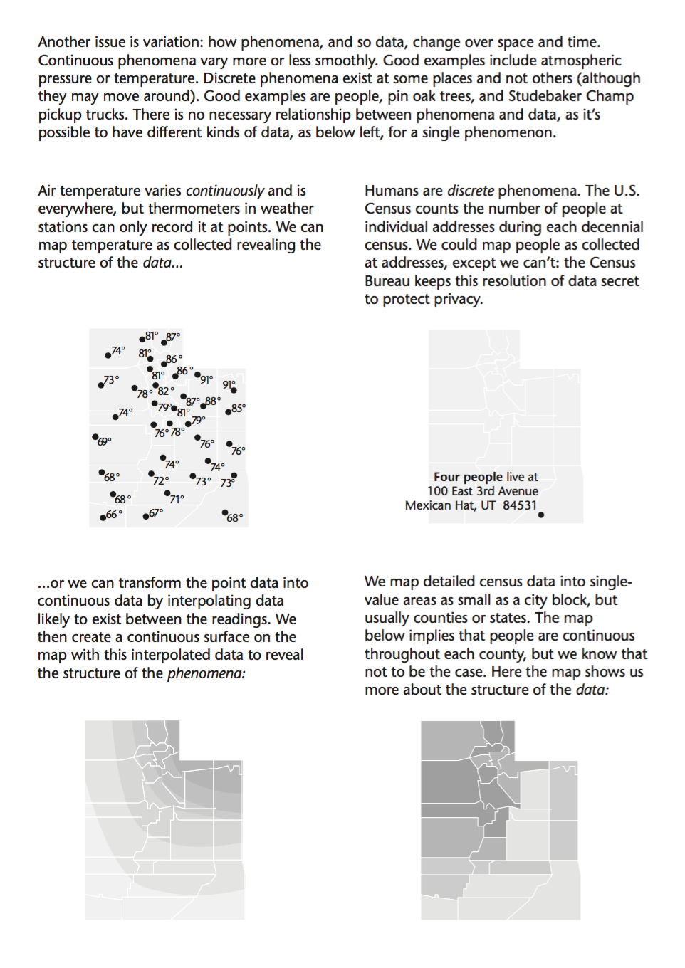
1. Phenomena and Data: individual & aggregate, continuous & discrete
- Phenomena are all the stuff out in the real world. Data capture
specific phenomena.
-
-
- from Making Maps
2. Creating & Geting Data
We have already engaged the oldest and most basic way of acquiring data:
- direct environmental perception with our senses: Exercise 1
Limited in its usefulness for making cartographic maps in most cases
We may use what we know via environmental perception to check other forms of data
Systematic data collection methods
- systematic: following a set arrangement, design, or pattern.
- primary methods: direct collection of environmental data
- look at four: ground survey, GPS, census, remote sensing (briefly)
- secondary methods: using already collected environmental data
2a. Ground Survey: Primary Systematic Data Collection
- WWW) Land Surveying
Ground survey is based on the idea that we can specify the positions of
environmental features in terms of other features with known positions.
Using surveying instruments, a surveyor works from a known position / elevation
then calculates accurate new locations by measuring distances and angles away
form that known, accurate position
Bench mark: a known location/elevation that meets a defined standard of accuracy
- on topo maps ... and on the ground
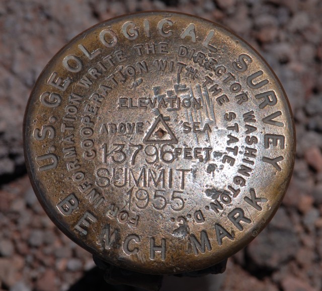
Handout) Delaware Topo
- extra credit! find a benchmark, do a rubbing on paper (with pencil, crayon)
- turn it in and get 10 pts (due one week from today)!
Calculating the positions of other features can be done by hand with geometry
and trigonometry or with computers
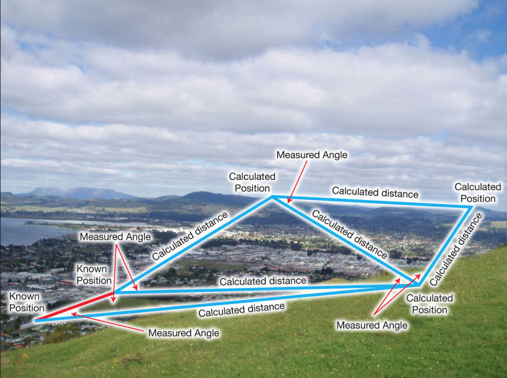
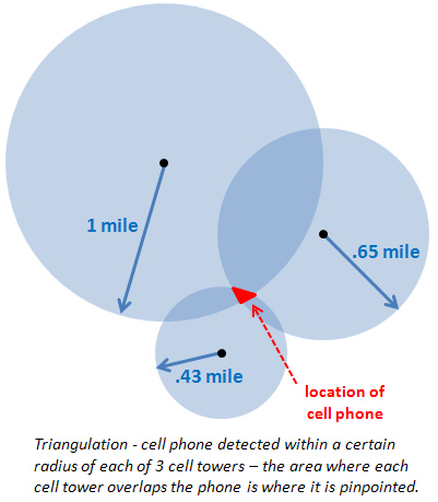
- "Triangulation is a surveying method that measures the angles in a triangle formed by three survey control points.
Using trigonometry and the measured length of just one side, the other distances in the triangle are calculated."
- Electronic distance meter (EDM) used to measure unknown distances
- "Each of the calculated distances is then used as one side in another triangle to calculate the distances to another point,
which in turn can start another triangle."
- "The angles in the triangles are measured using a theodolite, which is an instrument with a telescope connected to two
rotating circles (one horizontal and one vertical) to measure the horizontal and vertical angles."
- EDM + Theodolite (augmented with GPS) = surveying total station.
- Positional information can then be augmented with additional attribute information
- Drawback with ground survey:
2b. Global Positioning Systems: Primary Systematic Data Collection
Global Positioning Systems (GPS): global network of satellites orbiting the
earth and generating signals which can be used in tandem with GPS receiving units
to pinpoint location and elevations
- GPS has revolutionized primary systematic data collection
- inexpensive units: accuracy within 10 meters or less
- GPS everywhere: a 'consumer electronics' item
- drawbacks:
- necessary for 3 - 4 satellites to be in 'view'
- problems in urban areas, forests: no reading due to obstructions
- inexpensive units: accuracy of 10 meters not acceptable for some uses
- Does GPS make you stupid?
Yes and
Yes and
Yes and
Yes and
Yes...
Origins and Development of GPS:
- LORAN (and DECCA): ship navigation system (late 1930s-50s)
- ground stations transmit signals; LORAN receivers calculate
position based on relation to signals from different stations
- limitations: major water areas; 300 meter accuracy
- GPS: 1976 funding approved for US Military development of satellite based
system for determining locations
- immediate concern: logistics problems in Vietnam War
- functioning in early 1980s
- Gulf War (1990): test of the technology: organizing ground troops, integrating
location of planes, vehicles, and use of GIS for military planning.
- Non-military uses: first commercial GPS receiver 1984
- 1997: $2 billion dollar industry
- Selective availability: intentional garbling of GPS signals by
military to non-military users: 100 meter accuracy for non-military uses
- development of differential correction (DGPS): correction of inaccuracies
- European Galileo system: competition
- Selective availability removed in 2000
How GPS works
- 21 (+spares) GPS satellites in orbit around the earth
- GPS tracking stations: measure GPS satellite signals, compute orbital locations,
send this data to the satellites, which in turn send data to Earth-based GPS
receivers.
Calculating locations on Earth with GPS
- GPS satellites continuously transmit signals indicating each satellites:
- position in space
- exact time signal was sent
- how long does it take signal to travel from satellite to ground receiver?
- with three satellite signals (position + time signal sent from each): calculate
location (in coordinate system such as latitude/longitude)
- problem: very slight inaccuracies in time (hundredth of second) can
skew location by thousands of miles
- solution: use reading from 4th satellite: provides very accurate
locations and can also determine elevation of receiver
GPS Industry Now: Steady increase in sales.
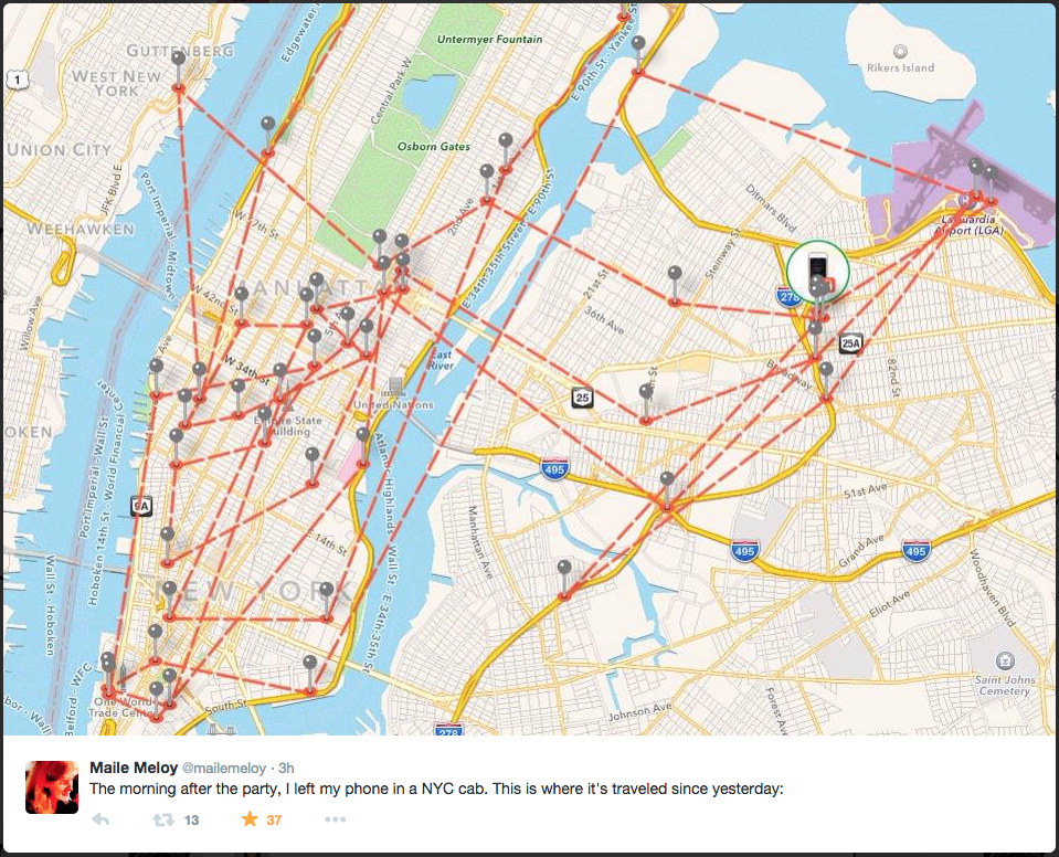
Locational Privacy...
- "I left my phone in a cab last night after the party..."
- "This Vehicle's Speed is Monitored by GPS"

GPS Sources:
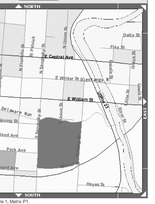
2c. Census & Sampling: Primary Systematic Data Collection
A census (or population count) is an inventory of individual
environmental features (human or physical) in terms of some predefined region
The characteristic of a census is
- 1. we know the area in which the data was collected
- 2. we know how many of some feature are in the area
- 3. but we don't know where, in the area, the features are located
- Census data is generalized.
Take this into account when using and mapping the data
A sample is he systematic collection of a limited number of instances of
environmental features in a given area, then a systematic estimate of the rest
of the features in the area
Necessary for continuous environmental features such as temperature and elevation
- we sample temperatures at a series of recording stations, not everywhere
- we sample elevations, using surveying instruments, at a few key locations
Then we estimate (predict, educated guess at) the rest
- process of interpolation and extrapolation
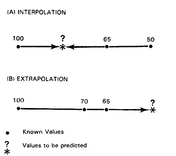
Interpolation: predicting the value at a location between two known values
- example) Buffalo = 60 degrees, Syracuse = 70 degrees, halfway between = ?
- example) elevations
Extrapolation: predicting the value that falls beyond the location of known values
example) measure of toxic chemical in the ground
- 100' south of spill site = 10% above acceptable levels
- 200' south of spill site = 5% above acceptable levels
- 400' south of spill site = 2.5% above acceptable levels
- 800' south of spill site = unknown
- extrapolate that it is 1.75%
Accuracy issues
Sampling is also used for discrete environmental features
- sample # of birds in a 10000 acre reserve at 10 equally spaced locations
- assume the percentages of different species at the 10 locations represent the
actual percentages in the entire reserve
- sampling allows us to take a small part of the population and infer what the
larger population is like
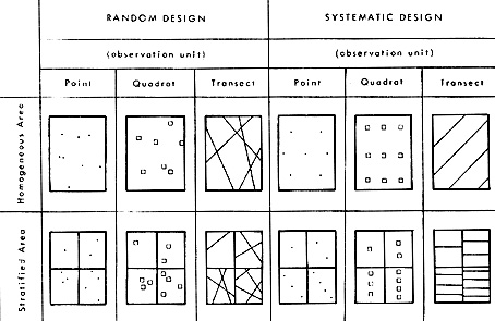
- variations in the size of the sampling area
- random vs systematic sample locations
Decisions about how to sample are based on the nature of the distribution
Most important aspect of sampling:
- methods that determine the characteristics of a larger population given a sample
- complex but well tested and used all the time
- ex) opinion polls: presidential election: accurate
2d. GeoCoding / Address Matching
- GeoCoding is the conversion of street addresses into mappable data (data that has
geographic coordinates). Also known as address matching.
- Exercise 3:
GeoCoding with GPS Visualizer
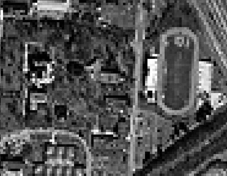
2e. Remote Sensing: Primary Systematic Data Collection
Remote Sensing is the indirect collection of environmental data, with
mechanical instruments; they serve as data collection means, "remote" from us.
Some remote sensing mechanisms are situated in a particular location
Data collected from numerous set locations can be compiled and mapped
Other remote sensing mechanisms are mobile
Remotely sensed data is best for recording physical features in the environment
3e. Compiled Data: Secondary Systematic Data Collection
Data based on secondary sources: published tables, text, or graphic sources
Compiled data is data gathered from such secondary sources
Maps often consist of a mixture of data from different sources
3. Data Organization
- In order to effectively gather, store, and manipulate geographical data, we
need a way to organize it.
- Level of Measurement / Quantification
- Digital Data Organization: two basic types: raster and vector
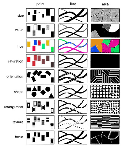
3a. Level of Measurement / Quantification
When data is collected and organized it must also have an associated level of measurement
Basic levels of measurement
- Making Maps chapter 3
- qualitative data: what? and examples
- quantitative data: how much? and examples
More sophisticated measurement levels: NOIR
Nominal: equivalent to qualitative data
- example: land use (commercial, agricultural, residential, industrial)
Ordinal: simplest form of quantitative data: just order
Can quantitatively order from low to high, but with no numeric difference between the classes
- example: feeling of fear in neighborhood: low, medium, high
Interval: order with numeric difference
Can order from low to high, with a numeric difference between the classes, but
with no absolute value for the numbers
- example: temperature fahrenheit: 60 deg. is 30 deg. more than 30 deg. but 60 deg. is NOT twice as warm as 30 deg. (the zero is arbitrary)
Ratio: order with numeric difference and absolute zero
Can order from high to low, with a numeric difference between classes, and with
an absolute value for the numbers
- example: population by county in Ohio: a county with 10,000 people has twice as
many people as a county with 5,000 people.
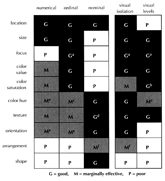
Why does this matter?
3b. Digital Data Organization
Object Oriented Data Model: Vector Data Model
Based on recognized environmental entities: points, lines, areas
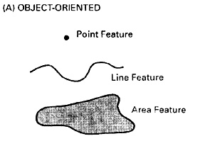
- Point features: mountain, town, well
- with the coordinates of its location (lat / long)
- Line features: river, road
- with a string of coordinates defining its location
- Area features: lake, state forest
- with a string of coordinates which closes, defining its location
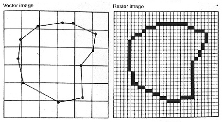
Location Oriented Data Model: Raster Data Model
Impose a grid over an area and record if some phenomena is or is not in each cell
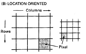
- example:
Why does this matter?
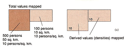
4. Transforming Data
Geographic data is often transformed and available in derived forms
Raw information - whole numbers are manipulated into some kind of form more suitable for mapping
- examples) averages, ratios, indexes, deviations, regressions
- ArcGIS) Choropleth map of Census Data
- whole numbers: choropleth map: problem
- states with larger population tend to have more Hispanics
- makes more sense to look at the percent Hispanic population
- how many Hispanics per 100 total population?
- derived data
Often need to derive data in order to map it effectively
5. Time & Data
6. Data Accuracy
Accuracy is complicated!
7. Digital Data
Geographic data, metadata, and copyright
Conclusions
The quality and usefulness of any given map is in large part based on the
nature and quality of the geographic data used to make the map
Vital to remember that we are not mapping what is out there in the environment
- we are mapping data that represents what is out there
We conceptualize and categorize the world
- features and their dimensions and their assumed characteristics
Then we collect and organize and quantify and inventory and derive the data
- based on those conceptualizations
And it is this highly manipulated data upon which we base our maps
E-mail: jbkrygier@owu.edu
...to Geog 222 Main Page and Course Description
...to krygier teaching page.
...to krygier top page.
OWU Home
OWU Geology and Geography Home