Geography 222 The Power of Maps and GIS
...to Geog 222 Main Page and Course Description
...to Geog 222 Syllabus
...to Geog 222 Course Schedule and Lecture Outlines
...to Geog 222 Exercises
Geog 222 Lecture Outline: A Cultural History of Maps
Update: 10/6/17
Maps reflect cultural & social factors:
Maps reflect personal experiences, interests, and knowledge:
- Psychogeography maps (Exercise 1)
The "histories" of cartography: many different "episodes"
Usual story: progression from less accurate/less knowledge of world to more accurate/more knowledge of the world
- the "accuracy" perspective: focus on the increasing geographic accuracy of maps
- but this is only part of the story
We can also approach to the history of cartography with a perspective that looks
at maps as reflections of different conceptualizations of the world from
different cultures and times.
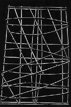
- Pacific Islander stick chart: winds and waves.
Mapping reflects what is culturally important at particular times and in
particular places: avoid judging all maps by geographical accuracy alone
1. Prehistoric Maps
Four general kinds of maps from prehistoric cultures
1a. Pictographs: map-like pictures: how does the idea of a view from above start?
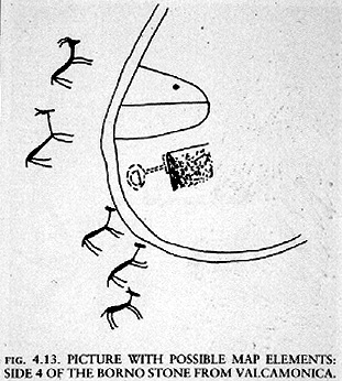
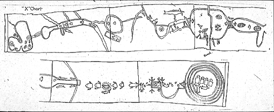
- Valcamonica rock carving: Bronze Age (2000 BC)
1b. Plan or Topographic maps: the view of the landscape from above: foundation of
what most people think of when they think of maps
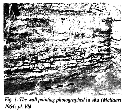
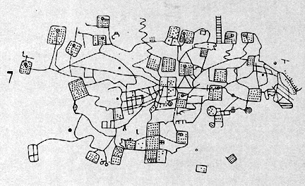
- Above: Actual Catal Huyuk "map/city plan" (6200 BC)
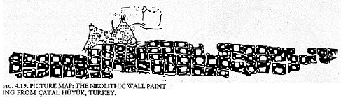
- Above: Catal Huyuk "map/city plan" as illustrated
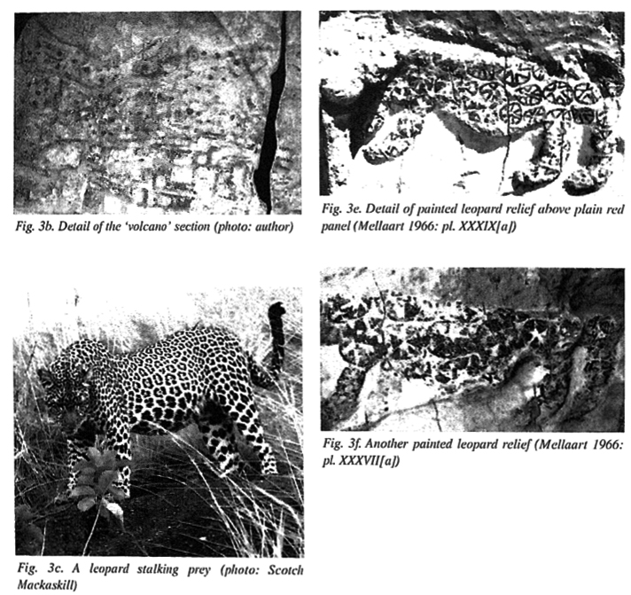
- Above: Catal Huyuk leopards?
- Valcamonica topographic rock carving (Bronze Age)
1c. Star maps: representing the heavens
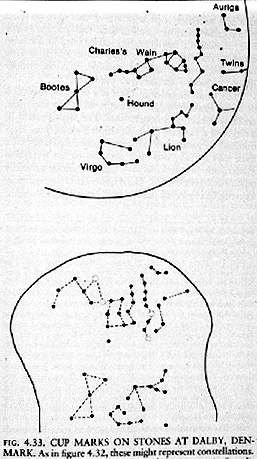
- Dalby Denmark cup marks (constellations; prehistoric)
1d. Cosmological maps: representing the world of belief : symbolic maps of a
culture's beliefs about the world
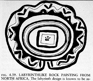
- North African Labyrinth: life path to death then path to afterlife
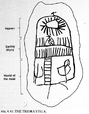
- Triora Stela (prehistoric, from Brescia, Italy)
Differing cultural reasons for mapping; understanding the world
- how and why did the mapping impulse start?
- why were things mapped the way they were?
- how have narrow definitions of maps and mapping limited our understanding?
- BUT for the most part, mapping is widespread, diverse, and rare
2. Ancient Middle East
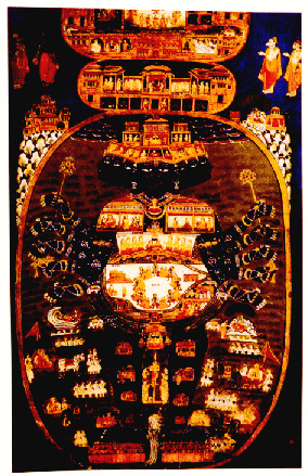
Cosmological maps: all over the world
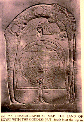
- Land of Egypt with the goddess Nut (350 BC)
Foundations of modern concern with geographical accuracy: why?
- ...sort of equivalent in importance to...
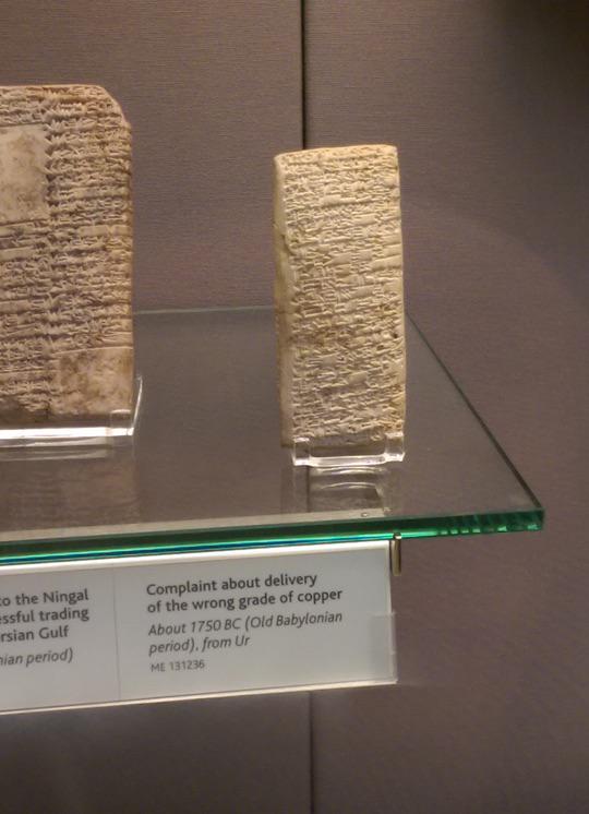
- Babalonian: 1750 BC: Complaint
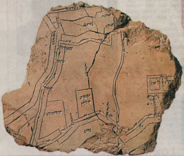
- Egyptian Gold Mine Map ( approx. 1000 BC)
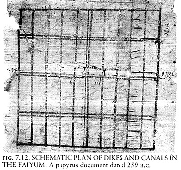
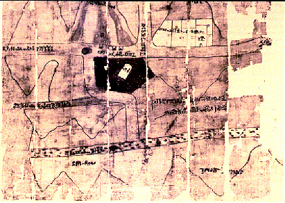
- Egyptian map; delta (259 BC)
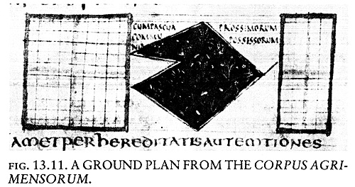
- Roman large scale maps and surveying
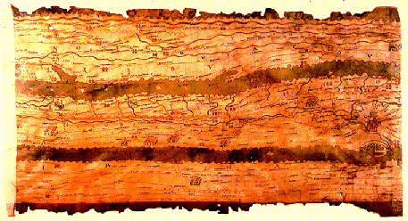
- travel and administrative maps: Peutinger Map (400 AD)
Maps revealing a speculative scientific interest in the world: the Greeks
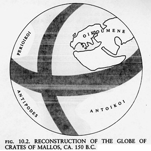
- Greek: Globe of Crates of Mallos (150 BC)
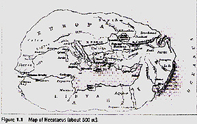
- Dorling 1.1: World Map by Hecataeus (500BC)
...this cultural episode
- widespread cosmological mapping by most cultures around the earth
- origins of scientific mapping in Ancient Near East
- linked to practical, economic issues: land and resource ownership
- linked to political issues: administration of territory, fighting wars...
- and scientific curiosity about the world: the Greeks in particular
- BUT for the most part, mapping is widespread, diverse, and rare
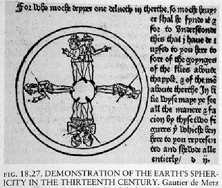
3. Cartography in the 1st half of the Millennium: 400AD to 1450
This era: geographically accurate maps in many places around the world
Ptolemy (Greek, 100AD): work serves as basis of modern cartography (Dorling p. 11)
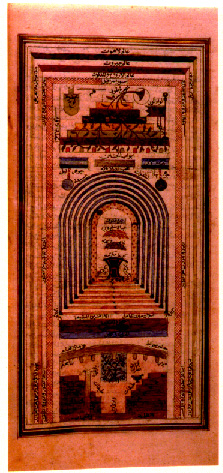
Islamic Cartography
- developed scientific approaches to geography and mapping
- travel and colonization of huge chunk of the world
- several important stages
- early stage: 800AD to 1000AD: building a tradition; influence of Greek ideas
- middle stage: 900AD to 1200AD: interest in regional geography
- later stage: 1100AD to 1400AD: typified by Idrisi
Move back to Europe around the same time - early in the 1st Millennium
- A major shift in European culture: religious belief predominates
- Dorling: "Knowledge of the physical world was considered secondary to the
required knowledge of the spiritual realm" (p. 15)
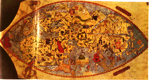
- Christian cosmological maps, however, were important
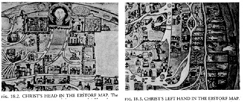
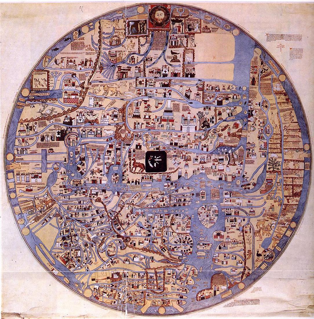
- Ebsdorf Map (above, detail of head and hands of Christ gathering up the world; full map below)
Survey of English manuscript maps for the period 1150-1500, and on European printed
regional maps for the period 1500-1600 (by Catherine Delano-Smith, for Volume 3 of
The History of Cartography Project):
- Maps from 1150-1500:
- 37% orientated to north
- 13% to east
- 23% to west
- 26% to south
- Maps from 1500-1550:
- 57% to north
- 5% to east
- 5% to west
- 31% to south
- Maps from 1550-1600:
- 94% to north
- 2% to east
- 2% to west
- 2% to south
Four types of medieval maps: tripartite, zonal, quadripartite
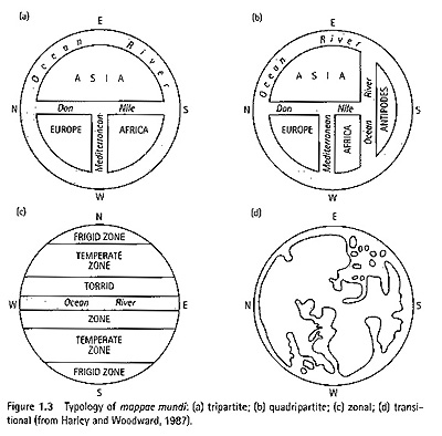
- tripartite ...even though the world looks flat...
- zonal
- quadripartite ...and people to populate the antipodes:
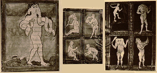
- The monstrous races in Antipode
- Abarimon: backwards turned feet
- Amazons: warlike women who live without men and sear off their right breast in
order to draw bow (matriarchal African societies)
- Amyctyrae: protruding lower lip, live on raw meat (Ubangi in N. Africa)
- Androgini: characteristics of both males and females
- Anthropophagi: cannibals who eat their parents when they get old
- Antipodes: can walk upside down
- Artibatirae: walk on all fours
- Astomi: survive on smells alone; cannot eat nor drink; will die if they smell a bad odor
- Blemmyae: faces on their chests; no head or neck
- Bragmanni: naked wise men who live in caves (Brahman [Hindu] holy men from India)
- Cyclopes: one eyed giants (Watusi in N. Africa)
- Cynocephali: dog-headed race; communicate by barking
- Donestre: speak the language of any traveler they meet; claim to know his relatives;
then kill the traveler and mourn his death
- Ethiopians: race of burnt (black) men who live in the mountains in Africa (North Africans)
- Gorgades: hairy women who live in Africa (Gorillas)
- Himantopodes: race with long, strap-like feet
- Hippopodes: race with horses feet (genetic mutation among some Africans
which results in feet w/ two toes)
- Maritimi: keen-eyed (four eyed) race
- Panotii: race who's ears reach their feet and serve as blankets; shy; use ears as
wings and fly away when approached
- Pygmies: race of short people (Pygmies of S. Africa)
- Sciopods: one legged but fleet-footed; spend days lying on backs protecting their
heads from the sun with their single great foot
- Sciritae: noseless, flat-faced race
- Speechless: race who communicate with gestures
- Troglodytes: race of "hole-creepers" who live in caves (N. African groups who live
in underground houses - like in first Star Wars movie)
- Wife-Givers: amiable race; give their wives to any traveler who stops among them
Late in this episode: emergence of exploration, trade, empire building in Europe
- transitional: religion meets geographical accuracy of Portolan charts
Yet again... for the most part, mapping is widespread, diverse, and rare
4. The Age of Discovery: Renaissance European Maps: 1450 AD onward...
Now mapping is widespread, somewhat less diverse, and not at all rare
Shifts in European culture correspond to shifts in European mapping
1490-1510: extensive growth in knowledge of the world
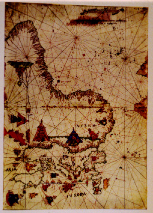
- Italian Navigation Map: why the orientation?
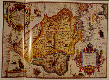
- Map of Dutch colonies in S. America
As the Europeans spread throughout the world: the Age of Discovery was also an
age of Encounter
5. Indigenous Cultures and Mapping
Terrestrial Mapping Tradition: mapping geographic phenomena
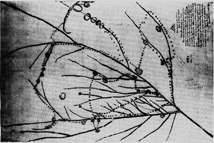
- Native American (Iowa) map of Upper Mississippi River Region
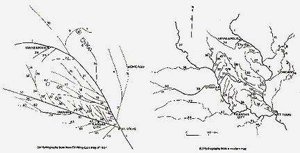
- Same Iowa map compared to modern map of area
Europeans borrowed much geographic knowledge from Natives, and incorporated
this knowledge on European maps
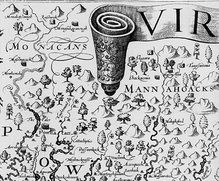
- John Smith map of Virginia (1612)
Transculturation: both Europeans and Natives changed each other; exchanged
mapping techniques, data, and geographic knowledge; across ('trans') culture exchange
of knowledge.
...other interesting Indigenous mapping traditions...
- Beaver Indian (Canada): "Oh yes, Indians made maps. You would not take any
notice of them. You might say such maps are crazy. But maybe the Indians would
say that is what your maps are: the same thing. Different maps from different
people - different ways." (from Brody, Maps and Dreams)
Cosmological Tradition: symbolic mapping of cosmologies and space
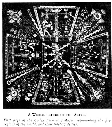
- Aztec map of the world, four regions, associated deities (pre-European contact)
- The maps represent, in a orderly manner, a culture's cosmology, but they are also
models for living: a "moral cartography," and a means of conducting one's life:
native people, then, "lived their maps." (Nabokov, p. 255).
The terrestrial and cosmological traditions were often not distinct:
- Devils Tower (Wyoming) is 60+ miles from its actual geographic location: WHY?
- because "the heavens took precedence over ... earth. Sometimes the latter (the earth)
deviated and had to be corrected..." (Nabakov, p. 81)
Phenomena we think of as real and distinct from the heavens and religious
belief may not be so distinct:
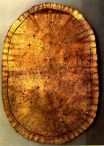
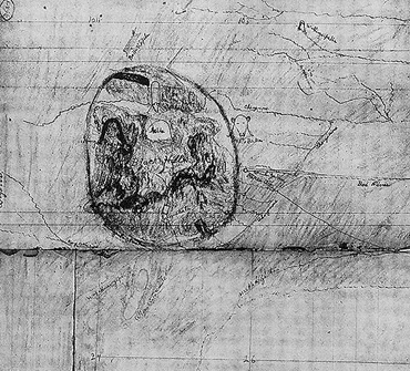
Confusing 'star map': does not match stars in the sky: inaccurate?
- NO: map of the heavens (stars) interspersed with actual earthly locations
- "Rather than an objective depiction of the night sky...its point is more likely
to draw the crucial connections in Pawnee cosmology between cosmic forces...and
the tribe's social and religious organizations that reflect and interact with
those heavenly forces" (Nabokov, p. 252).
- a substantially different way of understanding the world
6. Nineteenth and Twentieth Century
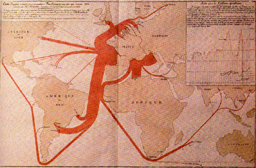
Origins of "thematic" cartography: maps of empirically measured physical and social phenomena
19th century: mapping of political, economic, social, and resource data;
This kind of data didn't exist before.
- British population, Petermann, 1849
- French wine exports, via Sea, 1864
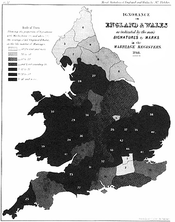
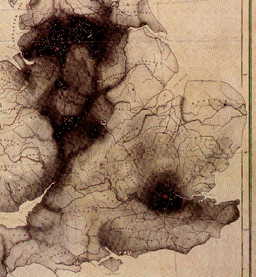
- Ignorance in the UK based on signatures versus 'marks' in marriage records, 1849
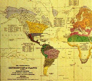
- Geographic distribution of plants, Johnston, 1848
Development of capitalism, interest in social issues, resources, interest in visualizing
empirical data >> again a cultural link to maps
WWW II
One consequence for mapping: Propaganda Maps
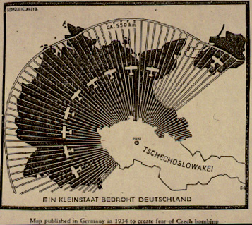
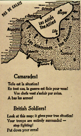
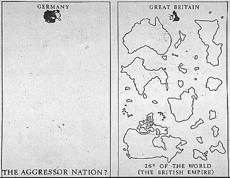
- Nazi Propaganda Maps, ca. 1940
But more importantly: Concern with the world and its relations: the birth of 'globalism.'
- Richard Edes Harrison: Look at the World atlas (1944)
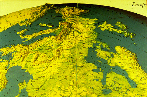
- Europe from the Soviet perspective.
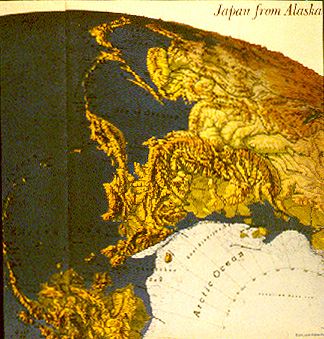
- Japan from the Alaskan's perspective.
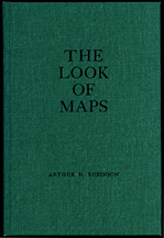
- Robinson: The Look of Maps: the origins of modern university cartography
Maps tangled up in different interests: reflect particular episodes in time,
culture
...a Cultural History of Cartography
One facet: development of geographical accuracy
- less accurate to more accurate maps
Linked to cultural characteristics which lead to exploration, trade,
colonization; scientific interest and economic factors
Another facet: Maps as reflections of culture rather than only geographical locations
- They can tell us much about other cultures: what was important, and central to
those cultures
- They reveal that reality is complicated, and the broad range of objects that we can call maps
E-mail: jbkrygier@owu.edu
...to Geog 222 Main Page and Course Description
...to krygier teaching page.
...to krygier top page.
OWU Home
OWU Geology and Geography Home