Geography 222 The Power of Maps and GIS
...to Geog 222 Main Page and Course Description
...to Geog 222 Syllabus
...to Geog 222 Course Schedule and Lecture Outlines
...to Geog 222 Exercises
Geog 222 Lecture Outline: Cartographic Maps
Update: 9/17/18
Recap: the way we envision or visualize the environment takes two general forms
- intangible maps: mental maps
- tangible maps: cartographic maps
PsychoSensory Mapping: valuable because...
- awareness of YOU as a "data" collection device
- gets you outside and paying attention to the complexity of the environment
- understanding of the breadth of stuff - things, senses, emotions - that can be mapped
- understand the narrow range of things that are usually mapped
- connect experience to data collection and mapping
- overwhelming complexity processed into (human) categories and abstractions
- ... then we think, act, speak, write, and map using those categories and abstractions
- maps are a human product - your psychosensory maps but also Google Maps and USGS maps.

1. Basic Components of Cartographic Maps
Many types of cartographic maps
- Real maps: maps you can pick up or touch
- Virtual maps: on the computer screen
Some basic elements of cartographic maps:
- map scale
- map graticule
- map projection
- map generalization
- map content
- map symbolization
- ...with examples on actual maps
1a. Map Scale
- Scale: Google Earth Zoom
Map Scale:
- the relationship between the map and the area portrayed
- size of an object on a map compared to the actual object on the ground
- Science Center: 1000 feet long on the ground, and 1 inch long on a map
- the map scale is: 1 inch = 1000 feet
- Google Maps or Map Quest.
Maps are always smaller than the portion of the Earth's surface they portray
Map Scale Types

Graphic scale: line or bar on map represents some set distance
Word scales: describes the scale of the map in words
Fractional scales: representative fraction: a proportion between map distance and Earth distance
- 1:100,000: representative fraction
- one unit on the map = 100,000 units on the ground
- Science Center: 1000 feet long on the ground, and 1 inch long on a map
- the map scale is: 1 inch = 1000 feet
- 12 inches in a foot, so [1000 x 12] = 12,000
- so the map scale is also 1 inch = 12,000 inches
- since the units (inches) are the same, drop them
- you get the representative fraction scale of the map: 1:12,000
- any 1 unit on the map (meters, yards, etc.) = 12,000 of the same units on the ground
Large and Small Scale Maps
Large scale / Small scale distinction is based on the representative fraction
- large scale maps have a relatively large representative fraction compared to small scale maps:
- 1:1000 = .001 is larger scale
- 1:10,000 = .0001 is smaller scale
- small scale maps: maps at 1:10,000,000 (or 'smaller') not much detail, generalized
- large scale maps: typically lots of detail; state size on a page or more detail
1b. Map Graticule
In order to locate phenomena on the earth we need some way to locate that
phenomena: a system of location. A grid of lines that intersect at right
angles is the simplest way to do this: The geographic grid or graticule:
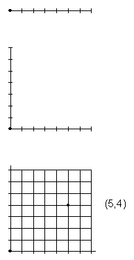
- Like a graph on the earth
There are many such grids/graticules: Map Locational Reference Systems
Most common grid: latitude (east/west lines) and longitude (north/south lines)
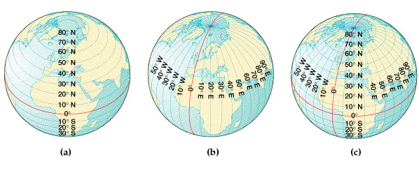
Latitude/Longitude is based on the rotation of the earth
- Latitude: distance measured north and south of the equator
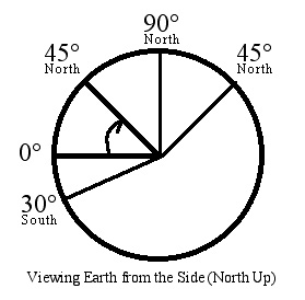
- based on the equator as a base line
- measured in degrees, minutes, and seconds
- parallel: a line connecting all points of the same latitude
- Longitude: distance measured east and west from an arbitrary meridian

- a meridian is a line of longitude
- an arbitrary meridian - the prime meridian - as 0 degrees
1c. Map Projections: flattening out the spherical earth
- ex) globe
- ex) different map projections (Interactive Album of Map Projections)
All flat maps distort shape or size or direction: can hold one constant, but not all three
What is vital to remember at this point is that all flat maps are projected and
the projection process always involves some kind of major map distortion
1d. Map Generalization: using judgement in the elimination of detail and
reduction of the number of features out in the "real" world:
 ...a map of everything.
- Muehrcke: "What makes a map so useful is its genius of omission." 12
- Monmonier: "Reality is three-dimensional, rich in detail, and far too factual
to allow a complete yet uncluttered two-dimensional graphic scale model. Indeed
a map that did not generalize would be useless."
- Google Maps or
Map Quest.
1e. Map Content: reference vs. thematic
Reference maps: general use (for many purposes): primary aim is to portray
human or environmental details accurately
- focus on and emphasize the location of things in the environment
- many different kinds of data on one map
- many different purposes
- ex) Google Maps or
Map Quest.
Thematic maps: particular use: primary aim is to portray a general spatial
pattern of one or several human or environmental phenomenon
- focus on and emphasize spatial patterns
- one or a few kinds of data on one map
- focused purpose
-
- ex) Animal Migration
- ex) US Languages
- ex) Fourteen ways to die in Shanghai
- ex) Pop vs. Soda
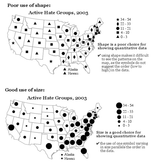
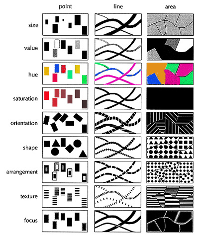
1f. Map Symbolization
Symbol: A thing representing something else because of relationship, association,
convention, or resemblance.
Map symbolization: guidelines and rules for symbolizing data on maps: the realm
of map making
2. The Cartographic Process: Map Making and Map Use
A broad, general way to look at cartographic maps in terms of the cartographic
process
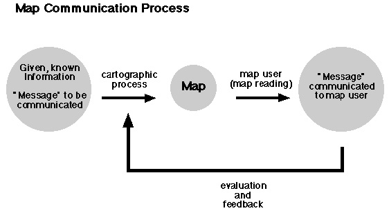
- Cartographic Process = Map making: activities involved in creating a cartographic map: data collection
and cartographic abstraction and symbolization
- Map use (or Reading): map user's process of transcribing the cartographic map
back into a mental picture
3. Map Making: factors which influence how and why a map is created
3a. Map Purpose
There are a multitude of purposes for which a map can be designed
- Making Maps ch. 2) What's Your Map For?
3b. Geographical Reality
Some aspects of reality are easier to map than others:
- Easy to map roads, rivers, and trails; difficult to map fear or beauty.
The reality you are mapping varies:
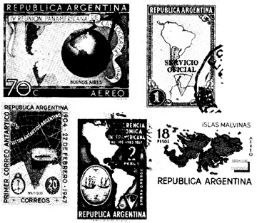
- Argentina includes the Falkland Islands (Malvinas) and part of Antarctica
as their official territory on their postage stamps.
3c. Data Availability and Quality
Availability of data to map varies:
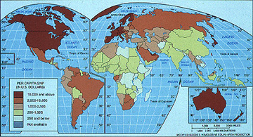
- Related to wealth of country (GNP Map above), political situation (secrecy), etc.
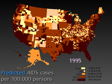
- Related to privacy (AIDS cases, above)
Quality of data to map varies
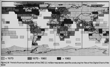
- Digital Chart of the World: varying age of data
3d. Technical Limitations
What a map looks like can be the result of the equipment used to create the
map, the cartographer's skills, and the time, budget, and labor restrictions
imposed on the map making process
3e. Conditions of Use
Maps are shaped for the conditions of use
- Maps for low-light situations
- Color choices on maps for kids vs. adults vs. older people.
- Making Maps Ch 2) Experts vs Novices (pp. 21)
- Making Maps Ch 2) Final Form of Map (pp. 22-27)
- Computer Monitor
- Black and white, on paper
- Color, on paper
- Projected
- Posters
- PDA, car navigational system, etc.
4. Map Use: Map Reading, Map Analysis, Map Interpretation
Map use (reading) can be broken down into several steps: often happen simultaneously
- map reading: process of determining what the map maker has depicted
- what part of the world does the map show?
- what areas (countries, states, provinces, counties) are the data in?
- what is the topic of the map?
- how is the data shown (is the data transformed [averages, densities], classified into
groups, etc.)?
- when was the data collected?
- who created the map? (if you find a map without attribution, you can use an image
search to potentially find the source: go to Google Images and
click on the camera icon in the search box. Paste the URL of the map if it is on the internet, or upload
if it is on your computer)
- map analysis: process of seeing spatial patterns on the map
- if the data shown ranges from low to high (usually numbers), where are the
lowest areas? Where are the highest areas?
- do distinct regions or areas stand out (low, high, or otherwise)? Where are they?
- if the data shown is qualitative (differences in kind), are there distinct groupings
of similar phenomena?
- do distinct regions or areas stand out?
- map interpretation: explaining the patterns noticed in the map analysis; use
our own knowledge or sources beyond the map to interpret the patterns.
- how does your knowledge or external knowledge (stuff you look up) help explain the patterns?
- are there patterns you can't explain? What might you do to explain them?
- can you find (or think of) other maps that might help explain patterns on the map?
- what is the takeaway insight the map provides you with - after interpretation?
Example) College Basketball: % from each county in the US (darker = more)
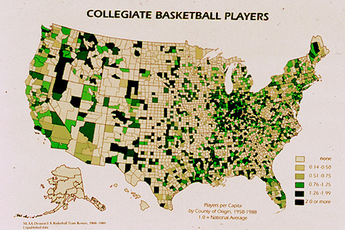
- map reading: process of determining what the map maker has depicted
- map analysis: process of seeing spatial patterns on the map
- map interpretation: explaining the patterns noticed in the map analysis
Example) Segregation in the US
Example) Military Recruits: % from each county in the US (tan = low, green = high)
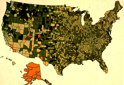
- map reading: process of determining what the map maker has depicted
- map analysis: process of seeing spatial patterns on the map
- map interpretation: explaining the patterns noticed in the map analysis
Next: a bit of cartographic history
E-mail: jbkrygier@owu.edu
...to Geog 222 Main Page and Course Description
...to krygier teaching page.
...to krygier top page.
OWU Home
OWU Geology and Geography Home