Geography 222 The Power of Maps
...to Geog 222 Main Page and Course Description
...to Geog 222 Syllabus
...to Geog 222 Course Schedule and Lecture Outlines
...to Geog 222 Laboratory Information and Student Projects
Geog 222 Take Home Exam 1
Update: 10/7/18
Due: Friday October 26 by 5pm
Exam 1: Writey up a total of 8.5 pages + 6 page Google Slides presentation + illustrations.
- This is a thinky rather than memorizey and regurgitatey
exam. It will be, I guarantee, the most interesting exam you've taken in this course.
- Page Format: Use space-and-a-half spacing, 12
point type, and 1 inch margins.
- Review the detailed yet comprehendible Digital Submissions
Guide. Screw up the formatting and I will deduct points, make you fix
the problems, and charge you a nuisance fee.
- Include the question you are answering prior to each answer
(copy and paste from this page).
- Cite any sources you use in an appropriate manner. You may use
any materials for the exam (books, lecture notes, lecture outlines, the web,
talking to people) but cite them.
- Plagiarism is copying other people's work without citation. You
can discuss the questions with each other but don't copy each other's work. I can
easily compare digital texts and have copies from previous semesters.
- Please contact me (jbkrygier@owu.edu) if you have any questions.
- More insightful, creative, and interesting answers will get higher grades.
You are being graded in relation to your peers in the class.
- Compile your answers into a single file, saved in your shared Geog 222
folder, add the Google Slides presentation (in the same folder) and email me when both are
complete. Make sure I respond
that I was able to access your masterpieces.
1. Maps as Arguments: 2 1/2 pages with illustrative maps
When defining maps,
early in the semester, I suggested they might be understood as propositions, or arguments
about the world. Review a lovely little comic constructed to argue this premise:
Ce N'est Pas le Monde. Remember this is meant to be a little booklet with
facing pages. I can get you a highly collectible paper copy if you want! Just ask. I will grade you based on how well you seem to get the stuff in the comic, which
I explained in class also (the Map People lectures)
- 1/2 page: summarize what is meant by defining a map as a proposition or argument.
- 1 page including map: describe how a typical classroom political map of the world is an argument about
the world (you can use the one in our classroom or here is the CIA's version)
- 1 page including map: find and describe another map as an argument about the world - from class (lecture outlines, exercises)
or from anywhere on the internets. Include a small version of the map in you answer.

2. Map Reading, Analysis & Interpretation: 2 pages
I yammered on about the process behind map use, including map reading, map analysis, and map
interpretation, as part of a memorable lecture on the nature of cartographic maps (in particular, "4. Map Use: Map Reading,
Map Analysis, Map Interpretation").
Choose two of the maps below, either the two World or two US maps.
- 1 page for each map: Map reading (1/4 page), map analysis (1/4 page), map interpretation (1/2 page).
as part of the map interpretation, indicate if you see any correlations between the two maps (world or USA).
- You don't must needs include the maps in the exam, but tell me which ones you are discussing.
- Right mouse click to open a larger version of the map
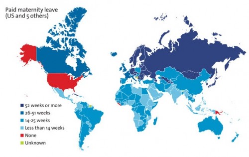 World Map of Paid Maternity Leave
 World Map of Death Penalty
- OR...
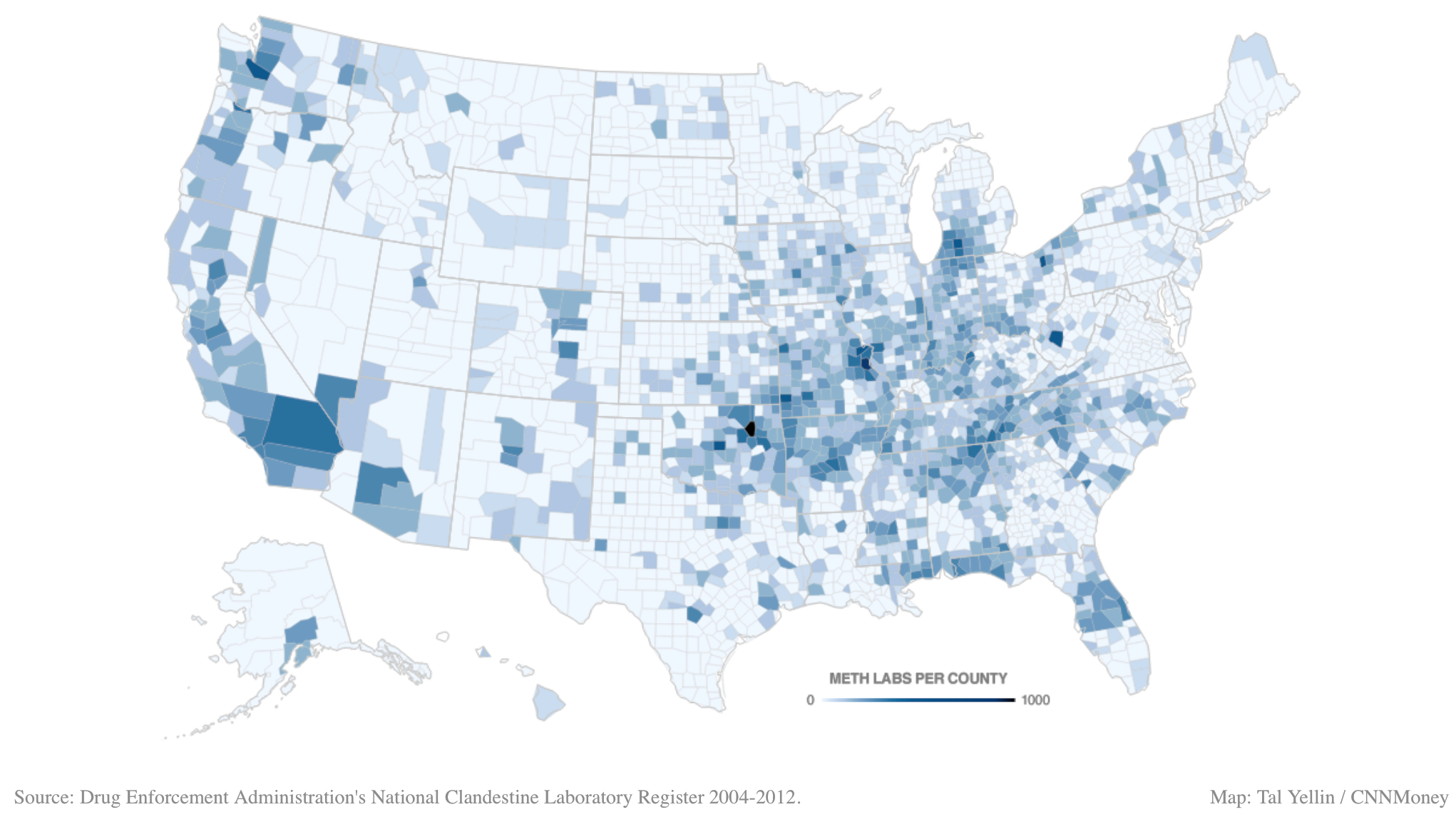 US Map of Meth Labs by County
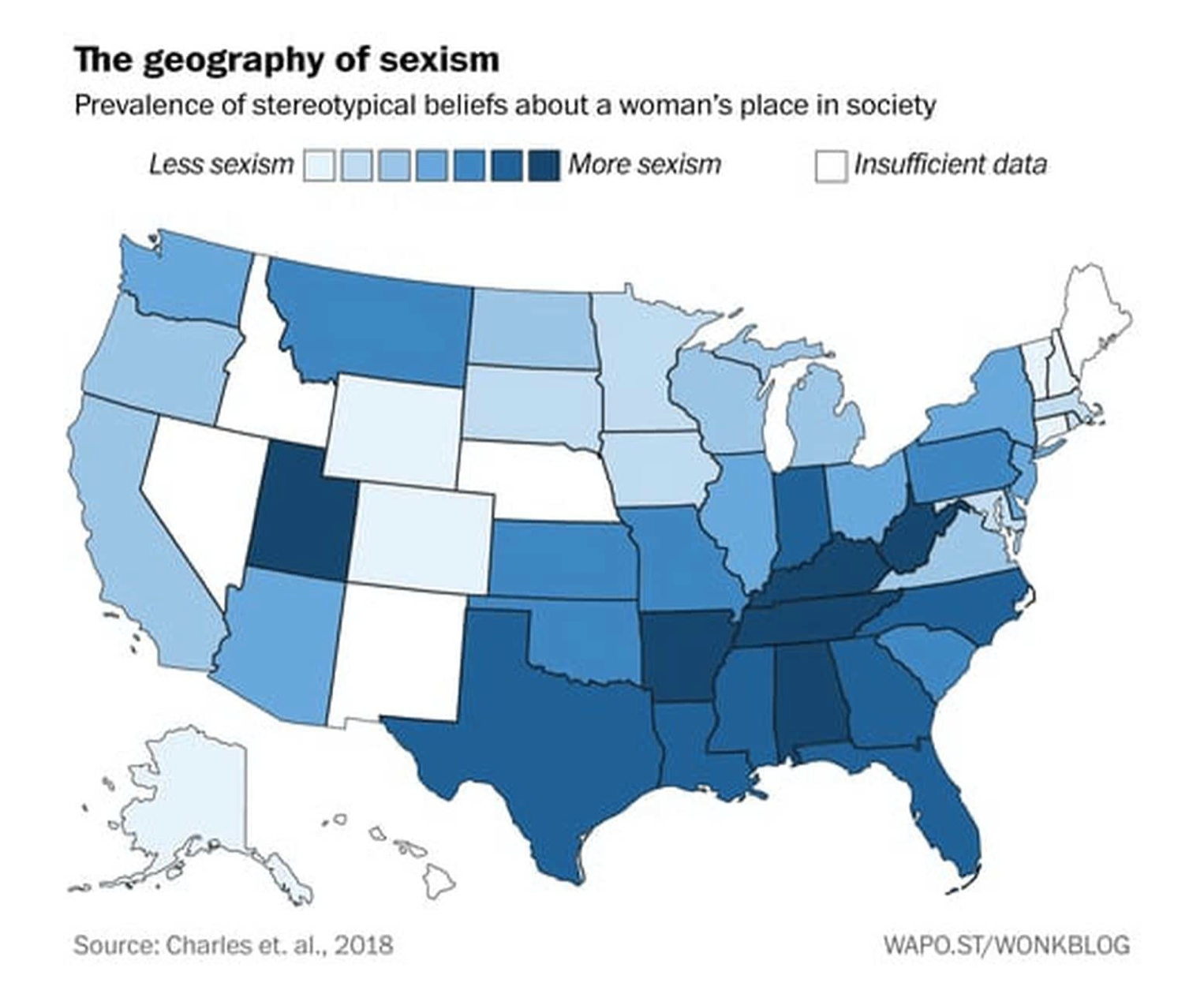 US Map of Sexism by State
(more info here)
US Map of Sexism by State
(more info here)

3. Mappable Data: 1 six page Google Slides presentation (!) shared with vaš instruktor
For some reason I've already forgot, I failed to finish my
Much Anticipated Discourse on Geographic Data in Geog 222 this semester.
- My therapist believes it had something to do with the sheer trauma (
 )
of so many unannounced late Exercise 2 submissions.
)
of so many unannounced late Exercise 2 submissions.
Regardless, you cannot have a complete life without exposure to the basics of geographic data.
Take a look at Chapter 3 in the Making Maps (3rd edition) book, either the book itself or a
suitable digital approximation (right here).
- To view the digital chapter in its appropriate two page spreads, please download it to your
computer and in Adobe Reader, locate and choose - from the View menu, Two Pages or
Two Page (continuous) or something like that.
Review the chapter and create a six page slide show in Google Slides (save it in your 222 folder with the Exam 1 document).
- You must capture the essence of the material covered in the chapter, key concepts and explanations
- You may skip the intro (pp. 56-59) and outro (pp. 80-81) material.
- Your audience for this presentation is at least one of your friends or acquaintances, not in the course,
who will be subjected to a 10-15 minute mini lecture on mappable data. If, like me, you don't have any friends, just
find some poor sap and offer them $5 to listen. Ask me for the $5.
- After the presentation, you may adjust the content of the presentation before submitting it to me if you got
feedback from your victim (aka, audience).
- You may include graphics if you want, but shoot for six pages of non-image content. To get graphics from the
chapter, use the PDF and screen shots.
- I have no frickin' idea how this will work out. Don't panic. Do your best. Squeeze the loaf. I'm bound to
be amenable and kindly in my grading, if you
give it the old college try.
4. Locational Privacy: 4 pages + illustrative map or two
Maps show us data, and data comes from a diversity of sources. In class we discussed GPS and
cell phone tower triangulation, which allows a smart phone to generate a relatively accurate
location for itself. When your phone is location enabled, you benefit - directions, nearby
shopping or eating, etc. But you are not the only one who benefits by knowing where you are.
Google, for example, uses data from your location enabled phone to generate its rather useful
traffic data.
- 1 Page: Take a look at Google Maps on your phone or on the web (on the web, click on
the word traffic under the search window). Zoom to around Delaware/Columbus, your US
home, and anywhere else you want to see how the traffic is doing. Comment on your
thoughts about this feature of Google Maps, if you use it, or if you might use it,
and how. Include an image of the traffic around your US home.
- On an iPhone do the following: Settings > Privacy > Location Services > System Services >
Frequent Locations, then click on any of the locations. If you have this turned off, you
can turn it on and check back a few days later. You can check this on a friend's
iPhone if you don't have one, or check (if you have a non iPhone smart phone) for a similar
function.
- 1 Page: Read the articles below and watch the vid below, and write a page or so summary:
- 2 Pages: Locational privacy, according to the Electronic Frontier Foundation (EFF)
"is the ability of an individual to move in public space with the expectation that under
normal circumstances their location will not be systematically and secretly recorded for
later use." Take a look at Epic.org's
resource page on locational privacy, and consider the general impact of locational
privacy on yourself:
- Describe instances where your location is not private. Think on this a bit, then
describe if you have a problem with this lack of locational privacy.
- Describe an instance
where you would be unwilling to give up locational privacy, and why. For example, how would
you feel if your employer wanted to know your location at all times during regular work hours?
A girlfriend/boyfriend? Spouse? Parent?
- Comment in
general about your perspective on the "threat" - or lack of threat - of the general decrease
in locational privacy. Do you worry about what the Government could do with this information?
Private business?

E-mail: jbkrygier@owu.edu
...back to krygier top page.
...to krygier teaching page.
...to geography 222 exercise page.
OWU Home
OWU
Geology and Geography Home