

Envisioning the American West
published in 1997 in Cartography and GIS 24:1, pp. 27-50.
A longer version of this paper (with many illustrations) is available.
"This method of representing topography is ... truer to nature. It is an approximation to a bird's eye view, and is intelligible to every eye." (Ives 1861 appendix D)
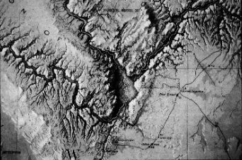
Upon first encountering the map by Baron Frederick W. von Egloffstein to which Joseph Christmas Ives refers to in the above quote, I was struck, as was Ives, by the power and authority of its carefully shaded terrain, a method of representation rare in maps of the era. Egloffstein's map represents a spectacular new way of depicting, seeing, and understanding terrain, and is unique among pre-Civil War maps of the American West (Irwin 1976 p. 74). William Goetzmann declared Egloffstein's map for the Ives report to be "one of the most important detailed maps drawn before the Civil War" (Goetzman 1978 p. 316). David Lavender, in his history of the Grand Canyon, comments on the "lovely" nature of Egloffstein's "three-dimensional ... rendering of the land's tormented topography" (Lavender 1982 p. 77). Carl Wheat, in his massive survey of the history of the mapping of the Transmississippi West, called Egloffstein "a genius" in regards to his representation of the Canyon (Wheat 1957-63 v. 5, p. 101). We are now conditioned to such representations of terrain and they pervade our imagination and understanding of landscape. Yet this map - a way of seeing and knowing - embodies a contradiction: we are provided with a "bird's eye view," "intelligible to every eye" and "truer to nature" which is simultaneously, as with every map, a wholly artificial "view" from nowhere. The map engenders "realistic effects ... based on a radical abstraction" (Crary 1995 p. 9). Cartographic exemplars, such as Egloffstein's map, pose a challenge to cartographers and geographers: what are the origins of such innovative ways of seeing and representing, and what is the process by which they came about? (Krygier 1995). Further, how can the analysis of such cartographic exemplars inform current debates about visual ways of knowing in geography and the role maps play in the production of scientific knowledge? (MacEachren 1995). Addressing such questions from a historical perspective can contribute to an understanding of visualization as a geographic and scientific method.
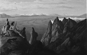
Baron Frederick W. von Egloffstein was a Humboldtean-inspired, Prussian-born artist and topographer who traveled with several U.S. Army exploratory reconnaissances in the mid-19th century American West. Born in Altdorf, Bavaria in 1824, he was the youngest son of Wilhelm von Egloffstein, lord of the Egloffstein manor in Francovia. Egloffstein, previously an engineering officer in the Prussian army, arrived in the United States in early 1849 (Krygier 1990). The era of exploration Egloffstein participated in - situated between the early 19th century "heroic" explorations of Lewis and Clark and the post-Civil War "systematic" explorations of King, Hayden, and Powell - has been called the "Great Reconnaissance" (Wallace 1955). Great Reconnaissance expeditions were functioning scientific enterprises, their charge to collect a diversity of data, information, and physical and cultural specimens - to document the cultural and physical landscapes of the American West. The ultimate product of Great Reconnaissance expeditions were lavish published accounts representing the scientific findings of the expeditions. Egloffstein constructed his map to accompany U.S. Army Corps of Topographical Engineers Lieutenant Joseph Christmas Ives' Report Upon the Colorado River of the West (1861), the first official exploration of the Grand Canyon. Along with Ives' text and Egloffstein's maps, the Report is filled with illustrations of locales and natives, panoramic landscape views, graphs, diagrams, and tables - a systematic "representational barrage."
How does one go about understanding the process by which the way of seeing and representing embodied in Egloffstein's map of the Grand Canyon developed? In order to explicate Egloffstein's map of the Grand Canyon, Ives' report, and the Great Reconnaissance representational barrage, one must recognize their scientific and cultural context - European Enlightenment ideas and Alexander von Humboldt's vision - all based on an explicitly visual way of knowing, a visual epistemology. This visual epistemology was modified and applied in the American West by Egloffstein and other scientific explorers. To understand the way of seeing embodied in Egloffstein's map the analysis must also move beyond the map. The results of an "intertextual" analysis clarify the process behind EgloffsteinĽs map. This analysis also reveals the map as one element within a complex of interconnected representations - the representational barrage of the published reports. I suggest that this "hyperworld" of interrelated representations serves as the conceptual framework upon which scientific knowledge was produced and communicated during the Great Reconnaissance.
An intertextual analysis of Egloffstein's map, understood within its cultural and scientific context, seems to reveal it as the end of a process of transformations whereby a situated view is meticulously transformed into an abstract map. Yet his map not only derives from but also depends upon explicit connections to situated views. Thus I argue that the map should not be understood as some kind of ultimate, authoritative representation, the "conceptual framework" or "synthesis" of the Great Reconnaissance expeditions (Godlewska 1995, Edney 1997). Instead, Egloffstein's map is enmeshed in a complex of representations - the representational barrage - which depend on and require each other, serving as an interconnected "hyperworld" necessary and useful for knowledge production. This hyperworld is a basic conceptual framework and product of a visual epistemology. The analysis of Egloffstein's exemplary map suggests the inadequacy of analyzing maps in isolation from other representations. The analysis implies a more careful consideration of the historical roots of visual ways of knowing which are often taken for granted in the literature on geographic methods, and in particular, geographic visualization. Finally, I suggest that the hyperworld of interrelated representations produced during the Great Reconnaissance bears a striking resemblance to multimedia and hypermedia: these "new" technologies have old roots and mimic a traditional conceptual framework for producing geographic (and scientific) knowledge.
1. Situating the "Great Reconnaissance"
2. The Representational Barrage and Intertextuality
3. One Path through the "Hyperworld"
Conclusions
Citations
Crary, J. 1995. Techniques of the Observer. Cambridge: MIT Press.
Edney, M. 1997. Mapping an Empire: The Geographical Construction of British India, 1765-1843. Chicago: University of Chicago Press.
Godlewska, A. 1995. "Map, Text, and Image." Transactions of the British Institute of Geographers NS 20. pp. 5-28.
Goetzmann, W. 1978. Exploration and Empire: The Explorer and the Scientist in the Winning of the American West. New York: W.W. Norton and Company (reprint of 1966 edition).
Irwin, D. 1976. "The Historical Development of Terrain Representation in American Cartography." International Yearbook of Cartography, 16:1. pp. 70-83.
Ives, J. 1861. Report Upon the Colorado River of the West, Washington DC: Government Printing Office. (U. S. House of Representatives Executive Document 90, 36th Congress, 1st Session, 1861). Reprinted as: J. Ives. 1969. New York: Da Capo Press.
Krygier, J. 1990. "The Landscape Images of Baron Frederick W. von Egloffstein, Topographic Artist in the American West, 1853-1859." Masters Thesis, University of Wisconsin Madison, Department of Geography.
Krygier, J. 1995. "Cartography as an Art and a Science." Cartographic Journal 32:6. pp. 3-10.
Lavender, D. 1982. Colorado River Country. New York: E.P. Dutton, Inc.
MacEachren, A. 1995. How Map's Work. New York: Guilford Press.
Wallace, E. 1955. The Great Reconnaissance: Soldiers, Artists and Scientists on the Frontier, 1848-1861. Boston: Little, Brown and Company.
Wheat, C. 1957-63. Mapping the Transmississippi West, 1540-1861. San Francisco: Institute of Historical Cartography.
E-mail: jbkrygie@cc.owu.edu