

Envisioning the American West:
Maps, the Representational
Barrage of 19th Century Expedition Reports, and the Production of Scientific
Knowledge
J.B. Krygier
Published in 1997 in Cartography and GIS 24:1, pp. 27-50.
A shorter version of this paper is available.
Figure 1: Rio Colorado of the West, 1858
ABSTRACT: A striking shaded relief map, created by Baron F.W. von Egloffstein to accompany the report on the first official exploration of the Grand Canyon in 1857-58, represents an important new way of envisioning America's Western landscapes. Ideas from the history and sociology of science, art history, and cultural geography are woven together as a means of understanding Egloffstein's important map, its cultural and scientific context, and its explicit interrelations with text and Egloffstein's illustrations and panoramic landscape views. The actual production of the illustrations, panoramic views, and maps is examined together with the manner in which these representations served as a vital means in the production of scientific knowledge. As such, this study is a contribution to an understanding of visual ways of knowing in geography and in science. I argue that historical cartographic exemplars can serve as an important means of understanding and informing current theoretical debates in cartography and geographic visualization.
This method of representing topography is ... truer to nature. It is an approximation to a bird's eye view, and is intelligible to every eye (Ives 1861, appendix D).
Upon first encountering the map by Baron Frederick W. von Egloffstein, referred to by Joseph Christmas Ives in the above quote, I was struck, as Ives, by the power and authority of its carefully shaded terrain (figure 1). Egloffstein's map represents a spectacular new way of depicting, seeing, and understanding landscape, and is unique among pre-Civil War maps of the American West (Irwin 1976, 74). It is one of the earliest maps of the Americas to use a shaded relief method of terrain representation, created with what has been called the first commercial half-tone process in the United States. William Goetzmann declared Egloffstein's map to be "one of the most important detailed maps drawn before the Civil War" (Goetzman 1978, 316). David Lavender, in his history of the Grand Canyon, comments on the "lovely" nature of the map's "three-dimensional ... rendering of the land's tormented topography" (Lavender 1982, 77). Carl Wheat, in his massive survey of the history of the mapping of the Transmississippi West, called Egloffstein "a genius" in regards to his representation of the Canyon (Wheat 1957-63, v. 5, 101). We are now conditioned to such representations of terrain and they pervade our imagination and understanding of landscape (Pike and Thelin 1990-91). Yet this map - a way of seeing and knowing - embodies a contradiction: we are provided with a "bird's eye view," "intelligible to every eye" and "truer to nature" which is simultaneously, as with every map, a wholly artificial view from nowhere. The map engenders "realistic effects ... based on a radical abstraction" (Crary 1995, 9). Cartographic exemplars, such as Egloffstein's map, pose a challenge to cartographers and geographers: what are the origins of such innovative ways of seeing and representing, and what is the process by which they came about? (Krygier 1995). Further, how can the analysis of such exemplars inform current debates about visual ways of knowing in geography and the role maps play in the production of scientific knowledge? (MacEachren 1995). This research considers both of these questions in the context of Egloffstein's map of the Grand Canyon. Addressing such questions from a historical perspective can contribute to an understanding of visualization as a geographic and scientific method.
How does one go about understanding the process by which the way of seeing and representing embodied in Egloffstein's map of the Grand Canyon developed? I suggest that one must recognize the map's scientific and cultural context - European Enlightenment ideas and Alexander von Humboldt's vision - all based on an explicitly visual way of knowing, a visual epistemology. This visual epistemology was modified and applied in the American West by Egloffstein and other scientific explorers. To understand the way of seeing embodied in the map the analysis must also move beyond the map. The results of an "intertextual" analysis clarify the technical and conceptual process behind Egloffstein's map; this analysis also reveals it as one element within a complex of interconnected representations - part of a systematic "representational barrage" in the published expedition reports. I suggest that this "hyperworld" of interrelated representations serves as the conceptual framework upon which scientific knowledge was represented and produced.
1. Situating the "Great Reconnaissance"
The lands west of the Mississippi were a major focus of attention for the United States in the nineteenth century. The explorations of Lewis and Clark in 1804-06 set in motion the agenda for the official U.S. sponsored explorations and surveys that would penetrate the West over the next fifty years. Issues and concerns involving the Transmississippi West increasingly permeated the thoughts and actions of the U.S. government and its citizens, shaping their images of the West, their nation, and themselves (Allen 1975; Goetzmann 1986; Cronon et al. 1992). In 1838 the Army Corps of Topographical Engineers evolved out of the Army Corps of Engineers. The Topographical Engineers were to serve as the official explorers and surveyors for the nation, and a subsequent expansion of scientific explorations in the West by the Topographical Engineers is evident in the 1840s and 1850s (Goetzmann 1979).
The era of exploration Egloffstein participated in has been called the "Great Reconnaissance" (Wallace 1955). Great Reconnaissance expeditions were functioning scientific enterprises, their charge to collect a diversity of data, information, and physical and cultural specimens - to document the cultural and physical landscapes of the American West. Army expeditions during the Great Reconnaissance were often focused on a specific goal: boundary survey, settlement possibilities, wagon-road survey, inventory of natural resources, railroad-route survey, etc. However, an encompassing scientific perspective drove the exploratory process; the expeditions were, as Cannon shows, "functioning scientific enterprises" (Cannon 1978, 79) much like earlier surveys in Egypt (Godlewska 1995) and India (Edney 1997). The U.S. Army sought to include a contingent of civilian scientists, including topographers, geologists, botanists, zoologists, and meteorologists in the exploratory parties. Accordingly, some of the most talented scientists in the United States and Europe were recruited for the task. The fundamental importance of the scientific explorations in the mid-nineteenth century American West is illustrated by the fact that the federal funding subsidy for the reconnaissances accounted for one-quarter to one third of the annual federal budget between 1843 and 1856 (Goetzmann 1986, 178).
William Goetzmann sees Alexander von Humboldt as the guiding force behind the method of U.S. Army exploration in the West before the Civil War, and has called this period "the age of Humboldtean science in America" (Goetzmann 1978, 235). Goetzmann argues that
All American earth scientists were eager for Humboldt's approbation, not only because of his mighty labors and his colossal preeminence in science, but also because he seemed to grasp the profound unity in nature - to be master of some overarching, transcendent, romantic secret about the whole earth and the cosmos that seemed to give a final meaning and direction to those efforts that began in the eighteenth century to know the mind of God through knowledge of His every manifestation in nature (Goetzmann 1986, 183).
Historian Susan Cannon claims that Goetzmann misconstrued what Humboldt stood for, seeing him, unjustly, as a "vague, Romantic idealist" (Cannon 1978, 79). Cannon isolates four elements that distinguish Humboldtean science, enmeshing him in the context of the broader Enlightenment project (Harvey 1989; Godlewska 1995). Humboldt "wished to promote worldwide observations not because of the intrinsic interest of a great many varied facts, but because he wanted general theories" (Cannon 1978, 80). The second aspect of Humboldtean science is an emphasis on empiricism and "being there" - collecting data in the field, a primary goal of the Great Reconnaissance expeditions. The third aspect of Humboldtean science is a concern with accurate measurement and measurement tools. This characteristic is exemplified by the concern with error and with variables that may interfere in the process of obtaining accurate measurement. This characteristic corresponds with the "emphasis on number and the instrumentality of knowledge" in Enlightenment thought, and provides a strong link to cartography and mapping (Godlewska 1995, 6). The final aspect of Humboldtean science is the use of what Cannon terms a "new set of conceptual tools" which were primarily visual (Cannon 1978, 95). These include new and innovative graphs, tables, sections, panoramas, and maps. Enlightenment thought suggested that "...the world could be controlled and rationally ordered if it could be pictured and represented correctly" (Godlewska 1995, 6). Humboldtean science was, thus, predominantly visual in its emphasis on field work, measurement, and representation. These same characteristics - the scientific approach, the importance of empiricism, accuracy of measurement, and visual methods - continue to dominate ways of knowing in geography, cartography, and geographic visualization.
The visual ways of knowing - epistemology - fundamental to Humboldtean science derived from European Enlightenment traditions. During the mid-seventeenth century a particular visual epistemology began to dominate European ways of knowing (Crary 1995). Vision as a way of knowing was privileged over other senses as it was understood to be at once less sensual and more mechanistic, particularly when guided by reason: "the senses deceive, reason corrects the errors." (Nietzsche, quoted in Crary 1995, 40). Innovative visualization technologies developed within this cultural and scientific context: telescopes, binoculars, and instruments which extended human vision beyond the visible - such as thermometers and devices for measuring atmospheric pressure. "Measurement" claims Edney, "became a surrogate for vision" (Edney 1997, ch. 2, 5). A related rise in the use of maps and other graphics for representing the physical and social world corresponds to the rise of visual ways of knowing in general (Rudwick 1976; Robinson 1982; Smith 1985; Knight 1986). The discipline of geography in particular, argues Godlewska, began to "explore the limits and potential of descriptions of all sorts, graphic and textual" in an attempt to stake out its disciplinary contribution to science in general: "...combining media, and in particular combining them in a rigorous manner, might lead to a new and more enlightening mode of description" (Godlewska 1995, 11).
By the mid eighteenth-century a visual epistemology and its associated instrumentation dominated the scientific endeavors of explorers and natural scientists traveling throughout the world, including Alexander von Humboldt (Livingstone 1992). These "scientific explorers" returned from their voyages to publish extensively illustrated narratives of "descriptive word wedded to accurate image." (Stafford 1984, xx). This "Plain" vision, as Stafford calls it, sought to represent natural phenomenon as it was, focusing attention on the creation of a vision divorced from metaphor and human preconceptions. As noted by Edney (1997) the Plain approach was more of a "tendency" than a distinct vision; it was a way of seeing and representing that one strove for rather than attained. The "Plain" approach was thus an attitude, guided by reason, that the world could be known, understood, and envisioned in a dispassionate, detached manner. The promotion of such an "attitude" continues to permeate recent literature on "exploratory data analysis" (EDA) and geographic visualization (Tukey 1977, MacEachren et al. 1992).
In contrast to the Plain vision (and often in tandem with it), the Picturesque vision arranged, constructed, displayed, and represented natural and artificial phenomena to fit particular anthropocentric moods, conventions, and ideals. Actual natural phenomena were, consequently, of less interest than the way in which they could be arranged and represented as stimuli to produce desired reactions. Travellers in the tradition of the "grand tour" and seekers of Picturesque produced fanciful, if not outright imaginary, accounts of adventure in the wilds (Adams 1962). Nature itself could be beautiful only when it was "like art and unlike itself" (Stafford 1984, 8). The Picturesque vision was, like the Plain, a tendency, although very programmatic at times. Guides provided instruction as to how any given view could be transformed and envisioned as Picturesque - "smooth mountains and ridges became rugged, and cliffs and ruined walls were foreshortened to tower menacingly over the viewer" (Edney 1997, ch 2, 12). The Picturesque served particular social and cultural goals, appealing to an educated elite who knew its conventions and codes, and could thus thoroughly enjoy the sublime and stirring vision of nature enhanced provided by the Picturesque (Mitchell 1994, Edney 1997).
Cutting across the Plain/Picturesque distinction is the contention by Crary (1995) that a fundamental change in vision occurred in the early 1800s. Crary argues that there was a shift, in the early nineteenth century, from a predominant concern with the "stable and fixed relations" of geometric optics (represented by the camera obscura) to physiological and subjective optics (Crary 1995 p. 14). Both artists and scientists began to redirect attention to the subjectivity of perception and, in particular, vision. Curiosity about visual phenomena - such as afterimages - led to the development of machines to study such "illusionary" phenomena; the rotating disks of the phenakistoiscope, for example, produced the illusion of movement and animation. The study of such "illusionary" visual effects began to dominate artistic, scientific, and popular culture. Crary points to Goethe, who exerted a strong influence on Humboldt, as a prime example of this transformation in vision and the status of these "illusionary" effects:
...in the early nineteenth century ... such experiences attain the status of optical "truth." They are no longer deceptions that obscure a "true" perception; rather they begin to constitute an irreducible component of human vision. For Goethe and the physiologists who followed him there was no such thing as optical illusion: whatever the healthy corporal eye experienced was in fact optical truth (Crary 1995, 97-98).
The distinction between geometric and physiological optics reflect tendencies and shifting emphases, and the details of the transformation are complex and not uncontested. What is of fundamental importance, however, is Crary's description of how increasingly, during the early nineteenth century, "the most pervasive means of producing 'realistic' effects ... were in fact based on a radical abstraction" (Crary 1995, 9). Such "means" can be innovative visual methods which provide insight and understanding and even truth via their "radical" abstractions. It is this radical abstraction which defines the power and authority of the map (Muehrcke 1990).
Stafford's contrast between the Plain and the Picturesque visions, and Crary's contrast between the geometric and physiological models of vision are two competing (sometimes contradictory and sometimes complementary) frameworks. Yet their insights do help to understand the complex cultural and scientific context which produced the way of seeing, knowing, and representing embodied in the Great Reconnaissance representational barrage. Plain and the Picturesque visions were modified and transformed in practice, given the contingencies of a particular landscape (the American West, the Grand Canyon), particular people (Egloffstein the Prussian Baron; Ives the vain, West Point topographical engineer), at a particular time (the 1850s). Geometric, situated models of vision coexisted with the "optical truths" produced by the "radical abstractions" of innovative visual methods; any educated individual in the early and mid 1800s would have been exposed to these different models of vision. The results of all these contingencies, scientific knowledge represented in the official expedition reports of the Great Reconnaissance, reveal the extent to which science and representation are embedded in a broader cultural context. The results also reveal the manner in which local, regional, and national factors shape scientific knowledge, "an enterprise hitherto regarded as prototypically universal" (Livingstone 1995, 16). Vital to the production of these scientific accounts was a substantially and explicitly constructed representational barrage - text, image, panorama, map - serving as the basis of scientific knowledge and action.
2. The Great Reconnaissance Representational Barrage
The final reports of Great Reconnaissance expeditions were published as large quarto volumes, profusely illustrated in color and linked to expansive maps, produced at great expense and widely distributed. Congress allotted $455,000 to the U.S. Army to survey four possible routes for a transcontinental railroad in 1853 (note 1). Publication of the results these reconnaissances, usually called the Pacific Railroad Reports, cost $1,200,000, over two and a half times the cost of the explorations - stark evidence of the profound importance of these documents (Taft 1953, 256). Reaction to the published reports - and in particular the representational barrage - was as grandiose. Senator James Harlan was transfixed by his copy of the Reports, stating to the Senate in 1859 that...
Every unusual swell of the land, every unexpected or unanticipated gorge in the mountains has been displayed in a beautiful picture. Every bird that flies in the air over that immense region, and every beast that travels the plains and mountains, every fish that swims in its lakes and rivers, every reptile that crawls, every insect that buzzes in the summer breeze, has been displayed in the highest style of art, and in the most brilliant colors (quoted in Taft 1953, 7).
For Harlan the reports were the American West transported to his desk in Washington D.C., a visual "hyperworld" upon which politicians such as himself, scientists, and the public derived their understanding of (and thus actions on) the West. The intermingled scientific and political purposes of the reports were duly noted by a contemporary reviewer who lauded "the publication of those scientific works" with which "the national honor is inseparably connected" (Anon. 1859; Daniels 1993). The published reports, then, were as - if not more - significant than the expeditions themselves. Their ultimate significance derived not from any individual fact, image, map, or diagram, but from the entirety of reports and their carefully interconnected representational barrage. To comprehend the reports, then, suggests an analytical approach - intertextuality - which focuses upon the published reports as a "hyperworld" of interconnected representations.
Intertextuality generally refers to the interpretation of written works not as independent wholes, but in relation to other texts. Culler defines intertextuality as "sequences which have meaning in relation to other texts which they take up, cite, parody, refute, or generally transform" (Culler 1981, 38). One can, then, gain a deeper understanding of a text by delineating its interrelations with other texts. For insight, intertextual interpretation focuses on the the relations between a text and other texts, rather than the relations between a text and "the real" or "reality" (Stam et. al 1992. 205).
Intertextual relations between geographic representations have been examined by Cosgrove (1984; 1993), Harley (1987), Schein (1993), and Godlewska (1995). Cosgrove has conceptualized landscape as a palimpsest of "cultural images" which encompass "actual topography or ... its representation in words, pictures, or even music" (Cosgrove 1993, 8). Landscape, then, is a culturally driven "way of seeing" and knowing - a visual epistemology (Cosgrove 1984, 1). The focus of inquiry shifts to the constellation of representational systems studied not "in order to detect how accurately they represent specific real locations, but as forms of landscape themselves, different in medium but similar in significance to features on the ground" (Cosgrove 1993, 8). Godlewska argues that what is most interesting about geographic representations is "not their distance from reality, that [there] are errors or distortions ... but that they are systematic ... part of a larger whole (a body of literature, a system of spatial understanding and a system of social organization) ... the most powerful tools of spatial analysis ever developed" (Godlewska 1995, 5). It is possible to study the geographic representations in the Great Reconnaissance reports in terms of "how accurately they represent specific real locations" - a long tradition in the history of cartography - and such an approach has been applied to Egloffstein's maps (Seavey 1980). Yet this approach does not address the manner in which the reports and their representational barrage served as the conceptual basis upon which scientists produced knowledge - positionally accurate or not - and upon which politicians and others acted. Nor can it address the explicit and substantial interrelations between the representations in the reports, interrelations fundamental to understanding how the American West was envisioned and known. Intertextual studies of geographic representations can, then, complement more traditional historical studies of map accuracy.
Text, image, panorama, and map were not merely cobbled together in the reports, nor were they intended to be viewed independently. The barrage contains explicit and substantial interrelations that define the visual epistemologies - and scientific method - by which the American West was envisioned during the Great Reconnaissance. The ultimate goal of such scientific enterprises, the representational barrage in the published reports, served as carefully produced "microworlds" for scientists (and the public) back East and around the world (Livingstone 1995, 25). This "mobilization of worlds" - bringing the American West "home" - underpins the process of scientific knowledge production (Latour 1987, 223; Latour 1990). The published reports are thus analogous to archives and museums, where objects, facts, observations, etc. are assembled and contextualized in relation to each other, rather than to their original environment, to create "new complexes of knowledge" (Edney 1997, ch. 2, 2). An examination of any single representation misses the emergent power of the complex of simultaneously reinforcing representational systems. Written text is empowered by its linear and sequential structure; images and maps are empowered by their very different configurational and spatial structure. Written text makes up for the limits of the image or map; the image or map makes up for the limits of written text. The same object and data is represented in different ways, an idea which resonates in recent discussions of visual methods which avoid the "one map solution" (Monmonier 1991). The representational barrage must, then, be understood as inherently intertextual: a complex of interrelated images, illustrations, panoramas, maps, diagrams, graphs, text, and their cultural and scientific context.
Figure 2: Map of Beckwith Expedition Route, 1854
Baron Frederick W. von Egloffstein was a Prussian-born artist and topographer who traveled with several U.S. Army exploratory reconnaissances in the mid-19th century American West. Born in Altdorf, Bavaria in 1824, he was the youngest son of Wilhelm von Egloffstein, lord of the Egloffstein manor in Francovia. Egloffstein, previously an engineering officer in the Prussian army, arrived in the United States in early 1849 (Krygier 1990). The two major reconnaissances Egloffstein accompanied as an artist and topographer typify the explorations of the Great Reconnaissance. He accompanied Lieutenant Edward G. Beckwith in 1854 in explorations for the first transcontinental railroad, the 38th Parallel Pacific Railroad Survey (figure 2) (note 2). Egloffstein's second expedition in the West was with Lieutenant Joseph Christmas Ives in 1857-58 in an exploration of the Colorado River and Grand Canyon area (figure 3) (note 3). The Beckwith expedition represents a "linear" exploration: it was focused on a corridor through the West. The Ives expedition, on the other hand, represents an "areal" exploration, concerned with a specific area within the West. Together these explorations represent the process of bisecting (lines) then encompassing (areas) the American West.
Figure 3: Map of Ives Expedition Route, 1857-58
3. Egloffstein's Illustrations, Panoramas, and Maps
To explicate the way of seeing, knowing, and representing exemplified by Egloffstein's map of the Grand Canyon, I examine the different visual representations attributed to Egloffstein, tracing the relations between these representations and others in the reports, based on the ideas described in the second part of this paper. In addition, I examine elements of individual representations and the relations between different representations in terms of the cultural and scientific context described in the first part of this paper. The analysis is organized into three sections corresponding to Egloffstein's illustrations, panoramas, and maps. Panoramas represent a 180 degree sweep of the landscape, while illustrations are representations of a scene that could be seen by an observer in one glance. In the process of explicating the map, I provide evidence of a visual epistemology of science in practice and the resultant hyperworld.
3a. Egloffstein's Illustrations: "A Curious Schizophrenia"
While Egloffstein's map of the Grand Canyon has engendered accolades (as quoted in the introduction), commentators have found his illustrations curiously problematic, particularly those in the Ives report. Clarence E. Dutton claimed of Egloffstein's illustrations that "never was a great subject more artistically misrepresented or more charmingly belittled" (Dutton 1882, 144). Wallace Stegner saw the same illustrations as representing "the landscapes of a nightmare" and a "picture of the artist's dismay" (Stegner 1982, 51, 92). T.H. Watkins claimed the illustrations were "representations of an outraged imagination that could not reconcile itself to the canyon country's spectacular realities." The illustrations had, Watkins claimed, "surrealistic qualities" (Watkins 1969, 111, 113). Stephen J. Pyne, looking at Egloffstein's illustrations in tandem with his maps, argues that "divorced from the rigors of cartography, Egloffstein permitted his romanticism to luxuriate into topographic fantasies" (Pyne 1982, 20). D.R. Stoddart noted the "incongruous styles of illustration" (Stoddart 1985, 34) and Pyne detected "a curious schizophrenia" (Pyne 1982, 20). An understanding of the scientific and cultural context and intertextual relations of Ives' report explains the "curious schizophrenia" of Egloffstein's work.
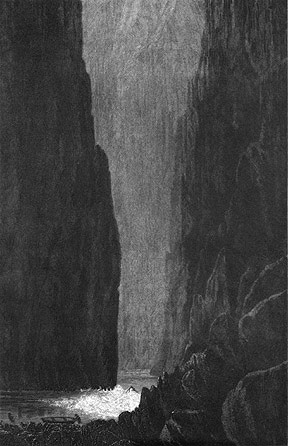
Figure 4: Black Canyon, 1861
It is not difficult to see the contrasts that provoked later commentators: Egloffstein's map for the Ives report (figure 1) belies a Plain vision that seems at odds with the illustrations, such as that of the Black Canyon of the Colorado River (figure 4). The illustrations have been judged on how accurately they represent what the Canyon actually looks like, and the correspondence is seemingly poor. Yet the accuracy of the depictions is only part of the story. The "incongruous styles of illustration" can be understood by examining the illustration of the Black Canyon in tandem with Ives' textual representation of the Black Canyon in his scientific report:
Stately facades, august cathedrals, amphitheaters, rotundas, castellated walls, and rows of time-stained ruins, surmounted by every form of tower, minaret, dome, and spire, have been moulded from the cyclopean masses of rock that form the mighty defile. The solitude, the stillness, the subdued light, and the vastness of every surrounding object, produce and impression of awe that ultimately becomes almost painful (Ives 1861, 86).
Figure 5: Sketch for Mouth of Black Canyon, 1857-58
Ives adopted an exorbitant Picturesque vision which fundamentally shaped his text and the illustrations attributed to Egloffstein. The text in Ives' report describes the Canyon and its environs in a panoply of coded metaphors and analogies which would certainly resonate with those educated in the Picturesque. Ives related his vision of the Black Canyon to Egloffstein, who, according to the text of the report, had not accompanied Ives into the Black Canyon. Egloffstein thus sketched a place he never saw. Further processing of the illustration took place in Washington D.C. Field sketches from the Ives expedition survive, and give an indication of the nature of the base materials Ives and the engravers had to work with (figure 5). Correspondence reveals that in mid-1861, before the report was published, Ives had written numerous times to the Superintendent of Public Printing complaining of the "poor quality" of the illustrations for his report (note 4). The unsatisfactory illustrations were sent back to be re-engraved by War Department engraver J.J. Young so that they "conformed more faithfully to originals" (Miller 1970, 224). Further, Ives passed over using two other sources of expedition sketches: those of the expedition geologist J.S. Newberry and those of Balduin Mollhausen, a German topographic artist who also accompanied Ives' expedition (Mollhausen 1861; Barba 1914; Miller 1970). Newberry's diagrammetric illustrations (as published in the geologic chapter in Ives' report) revealed the strata of the Canyon which was entirely missing from Egloffstein's illustrations (figure 6). A comparison of the mouth of Diamond River as attributed to Egloffstein and published in Ives' text (figure 7) and the same location as illustrated by Mollhausen and published in his account of the survey (figure 8) also reveals a distinct difference in vision. Ives had certainly seen Newberry and Mollhausen's visual materials and could have used them as the basis of the primary illustrations in his report, yet he chose not to. Ives, overseeing Young the engraver, became the guiding force behind the vision of the Grand Canyon as a hellish gothic abyss in his scientific report.
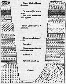
Figure 6: Section of the Ca�on of the Colorado, 1861
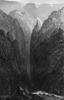
Figure 7: Big Ca�on at Mouth of Diamond River, 1861
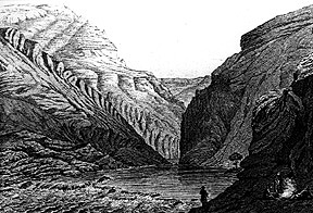
Figure 8: The Rio Colorado Near the Mouth of Diamond Creek, 1861
Joseph Christmas Ives, reports a contemporary source, "was very vain..., he talked of his Colorado expedition as the event of his life destined to make a name for his children" (quoted in Goetzmann 1979, 379). The unexplored Grand Canyon region provided one of the last big mysteries of the American West. The first ascension of the Colorado River, in a steamboat yet, was undoubtedly one of the most desirable Army assignments in the West. Ignored in Ives' report was the fact that he had been upstaged by George A. Johnson, an entrepreneur who had petitioned and been turned down by the War Department for the privilege of officially exploring the navigability of the Colorado River. Johnson, in a fit of exploration sabotage, navigated his steamboat up the Colorado just days before the Ives expedition began. Mollhausen noted the disappointment: "The prospect of being able to think during the journey that we were following along a route that had never been previously explored by a European lost its attraction" (Mollhausen quoted in Miller 1970, 175). Such complex motivations were embedded in the process of producing the scientific knowledge represented in the expedition reports.
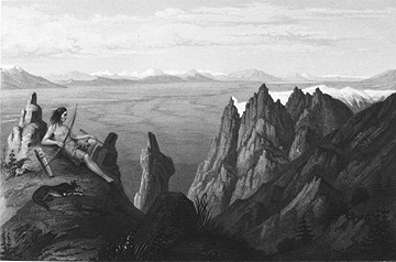
Figure 9: Franklin Valley, 1855
Ives' and other Great Reconnaissance reports were produced, presented, and accepted as coherent bodies of scientific knowledge about particular Western landscapes. Yet an examination of intertextual relations in the reports reveals how scientific knowledge was shaped by individuals with different intentions and visions. Without looking at the intertextual relations, the knowledge represented in the reports will seem confusing and even contradictory. Egloffstein's illustration of the Black Canyon and Diamond River - and the other illustrations attributed to him in Ives' report - are of multiple authorship, and this reveals itself in in the puzzlement over interpreting the illustrations, particularly in comparison to his map of the Grand Canyon. These contrasts may be seen as internal contradictions in the representational barrage (Duncan 1993). However, it is also possible to interpret the contrasts as reinforcing the authority of the reports. The visual and textual codes communicated by the Picturesque elements in the barrage would resonate among and reassure an elite audience, revealing the delineator's training, education, and social status. A landscape view from the Beckwith Expedition attributed to Egloffstein reveals the Plain and the Picturesque visions combined (figure 9). A stylized noble savage graces the left hand side of the published view. Original sketches by Egloffstein for the Beckwith landscape views contain no noble savages, revealing the multiple authorship of the panoramas (note 5). The noble savage has been interpreted as a distracting Picturesque element (Goetzmann 1979, 335). However, the savage is a Picturesque convention, and can be interpreted as a a symbol aimed at the educated viewer of the otherwise Plain illustration. Authority, then, can emanate from the multiple visions embodied in the representational barrage.
3b. Egloffstein's Panoramas: "Awe-Inspiring"
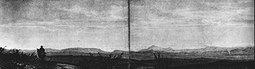
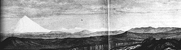
Figure 10: Northern Slopes of the Sierra Nevada, 1855 (top is left side of panorama, bottom is right side)
The panoramic landscape views Egloffstein constructed for the Beckwith and Ives reports represent a unique solution for depicting the vast spaces of the American West. The panoramas fold out of the volumes they accompany, spreading out over a meter of paper (figure 10). The panoramas provide a prime example of a visual epistemology in practice, as well as Humboldtean concerns with measurement, accuracy of vision, and the "magical" simulation of "being there" with innovative visual methods. The panoramas are explicitly linked to the maps, providing tangible evidence of the intentional intertextual relations among the representational barrage of the Great Reconnaissance reports. Further, the panoramas represent a vital step in the transformation of a situated view to the abstraction of Egloffstein's map of the Grand Canyon (Hillis 1994). Analysis of the panoramas, then, further explicates the complexities of scientific knowledge production via a visual epistemology and its ultimate goal in the production of a hyperworld.
Egloffstein's tremendous panoramas have not failed to impress viewers and commentators. Robert Taft, in a discussion of the Pacific Railroad Reports in his seminal study of the artists of the American West, notes that "[p]robably in none of the twelve volumes of this monumental work are the illustrations more specifically directed to the immediate purpose of the report, that of depicting the country through which a railroad would have to pass, than in these thirteen [panoramas] by Egloffstein" (Taft 1953, 263). William Goetzmann calls the panoramas for Beckwith "awe-inspiring" adding that in the Pacific Railroad Reports, "the best landscape work was done by von Egloffstein, whose steel engravings of the Beckwith expedition were a perfect exploitation of the tension between geographical accuracy and the 'stunned imagination'" (Goetzman 1979, 335). Goetzmann, in a discussion of the development of the panorama as a graphic form in the Great Reconnaissance reports notes that the form "was brought to a high degree of perfection by F.W. von Egloffstein" (Goetzmann 1978, 334).
The naturalistic opulence of the panoramas, however, makes it easy to miss their basis in an abstraction of geographic space. Egloffstein projected sweeping, 180 degree views onto a flat piece of paper, noting the vantage point and the left and right extreme bearings at the bottom of the panorama. The views illustrated in the panoramas are a means of representing, on a piece of paper, the view of an observer in the landscape if they were to turn their head 180 degrees. Thus it is possible to see in a glance on paper what it would be impossible to see in any one glance by an observer in the landscape.
Egloffstein was undoubtedly inspired by Humboldt who was himself inspired by the curious visual effects produced by the abstractions of the panorama:
Panoramas are more productive of effect than scenic decorations, since the spectator, inclosed, as it were, within a magical circle, and wholly removed from all the disturbing influences of reality, may the more easily fancy that he is actually surrounded by a foreign scene (Humboldt 1844, v. 2, 97-98).
Humboldt's revealing quote provides evidence of reliance on a visual epistemology. The visually innovative, "magical" panorama, can serve as a "more productive" means of bringing a "foreign scene" home in the hyperworlds of the published exploratory reports. Indeed, the abstraction inherent in the "magical circle" of the panorama is the source of its power and utility as a means of seeing and knowing. Thus the panorama is a "pervasive means of producing 'realistic' effects ... based on a radical abstraction (Crary 1995, 9). Much as with scientific knowledge in general, the removal of the "disturbing influences of reality" - the abstraction - is vital to understanding.
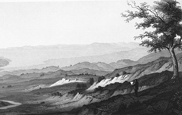
Figure 11: West End of Madelin Pass, 1855
However, the subjective perspective of the delineator is not denied nor excised from this artificial vision; it is, instead, retained as a referent, assuring the viewer that the abstraction is grounded in actual observation. In reference to 19th century British views of India, Edney argues that "[f]or the surveyors to be shown working within the landscape would subvert the entire ideology of geographical observation" (Edney 1997, ch. 2, 20). The opposite case may be made: the authority of the abstraction is empowered by evidence of subjective observation. On the illustration entitled "West End of Madelin Pass" stands a figure in the landscape, pen in hand, sketching the view in the distance (figure 11). The presence of a delineator in the image is a convention which can be traced to the town views of the sixteenth-century (Nuti 1988, 553). The implication here is twofold: first, that the image is sketched from a viewpoint located where the figure of the delineator is located; it is a symbol noting the vantage point of the view. Second, and more importantly, the presence of the delineator subtly implies that
you must take into account that the image on the sheet is not simply reality on display for your eyes, but that it is filtered through his special eyes; and consequently that it is the key to the whole image, its reason for being.... (Nuti 1988, 553).
This interpretation is supported by Beckwith in an Appendix to his report, an explicit discussion of the visual methods used by Egloffstein, a tradition from earlier European exploratory reports (Godlewska 1995, 19). Beckwith writes that Egloffstein recognizes that visual depictions
will be frequently influenced...by the varied impressions which the same landscape produces, depending upon whether it is seen during the morning of evening light of the day, under a clear of clouded sky, in a dry or wet atmosphere, etc. (U.S. War Department 1855, v. 2, appendix B, 125).
The importance of "the varied impressions which the same landscape produces" can be traced directly to the visual epistemology of Humboldt. Egloffstein had heeded Humboldt's observation that
The impression left on our minds by the aspect of nature is frequently determined, less even by the peculiar character of the strictly terrestrial portion of the scene, than by the light thrown on mountain or plain, either by a sky of azure purity, or by one veiled by lowering clouds (Humboldt 1849, 169).
We are asked to trust the delineator, his methods and reason. Trust is engendered by the explicit recognition of the characteristics of vision. The use of methods to check and extend vision - surveying instruments, telescopes, and pressure gauges - are noted. The intelligence and education of the delineator, reasons why we should trust his reason, are suggested by his methods. The symbol of the delineator in the view, the written explanation of methods and the characteristics of vision, and even the Picturesque noble savage are all venerable fundaments of a visual epistemology that only a well-educated and reasoned delineator would know. They are unsubtle clues that we can trust Egloffstein's "special eyes." Beckwith continues
Mr. Egloffstein...has endeavored to give such a character to his topography as to present a distinct representation of the country as it appeared to him when taking his notes in the field. The altitude above the sea of the great interior plateau upon which these mountains are elevated, materially diminishes their apparent altitude from whatever direction they are approached; and as it is their actual appearance to the eye which is attempted to be represented, it equally influences the character of their delineation (U.S. War Department 1855, v. 2, appendix B, 125).
Egloffstein, thus, defers to "uncorrected" vision in the delineation of his landscapes. Instrumentation used by Egloffstein revealed that the actual elevation of mountains was diminished by atmospheric effects. However, the panoramas do not attempt to correct for this. Instead, they represent the landscapes as he saw them, uncorrected by his instrumentation. In a subtile but important sense, this is fundamental to understanding visual ways of knowing - not privileging empirical measures of the material landscape over "actual appearance to the eye." Such empirical measures are recognized and established, yet they need not dominate. We can choose not to exaggerate the vertical dimension on digital terrain models, but we do, privileging vision (Kraak 1994, 272). Ives could have selected a Plain vision for the illustrations in his report, and Egloffstein could have chosen to "correct" his vision. They chose not to, instead representing the west as seen by their "special eyes."
This same visual epistemology suggests the abstraction of the "actual appearance" of the landscape into a panoramic format. The panoramas represent, at once, the "magical" and powerful results of an abstraction "from the disturbing influences of reality" imbued with the "actual appearance" of the landscape "to the eye." Egloffstein and Humboldt and other practitioners of a visual epistemology elevate the vision provided by "special eyes" and the "magical" effects of unnatural abstractions. The abstraction of the panoramas gains authority by the explicit connection to the situated view of a trustworthy observer. It is this vision and way of knowing which guided the construction of the panoramas and provided the scientific understanding and knowledge contained in the reports of exploration, transported back East for public, political, and scientific consumption.
Egloffstein's maps for the Beckwith and Ives expeditions take this process of vision and abstraction one step further, rising above the landscape and transforming the artificial view from somewhere in the panoramas to the "radical abstraction" of the map.
3c. Egloffstein's Maps: "Lovely" Maps of "Tormented Topography"
Mr. Egloffstein, the topographer to the expedition, conceived the idea�while sketching the naked mountains, barren plains, and immense gorges that characterized some portion of the region explored�of endeavoring to give to his map the appearance of a small plaster model of the country, with the light falling upon it at a particular angle. Such a model of a bare and rocky region would strongly resemble nature. This method of representing topography is less conventional than [hachures] and truer to nature. It is an approximation to a bird's eye view, and is intelligible to every eye (Ives 1861, appendix D).
It is doubtful that Egloffstein "conceived the idea" for his Grand Canyon map during the Ives expedition as Ives relates in the above quote, although it suggests the belief that spectacular places could inspire innovative visual techniques. It is likely that he was responsible for introducing shaded relief as a method of "suggesting landforms" in the United States (Goetzmann 1978, 343).
The method of relief shading used by Egloffstein is unique, but its rudiments may be traced to early nineteenth century French "shadow hachure" maps (Imhof 1982). The Ives report notes that Egloffstein's map in part "embraces a system of topography at one time adopted in France" (Ives 1861, Appendix D). Eduard Imhof describes the "shadow hachure" whereby "the light is supposed to fall at an oblique angle upon the objects represented; illuminating certain portions, and leaving others in shade." Imhof speculates that this technique may have evolved from eighteenth century French oblique bird's-eye views where variable terrain was illuminated by assuming a light source from the left. This idea was transformed into the planimetric realm of the map where the thickness of hachures was varied assuming a light-source from the north-west. Imhof notes that this method "produced a three-dimensional impression, reminiscent of obliquely lit terrain models" (Imhof 1982, 11). An examination of the explicit interrelations between Egloffstein's panoramas and his maps for Beckwith and Ives provide evidence for Imhof's speculations about the derivation of shaded terrain representations from panoramic views.
Egloffstein had conceived of the idea represented in the final map for the Ives report by 1857, after the Beckwith expedition and before the Ives expedition. This is suggested by the publication of a folio by Egloffstein entitled New Style of Topographical Drawing, derived from late experiments with the photograph and daguerreotype, from Mountain models, as suggested by Baron A. von Humboldt (note 6). The "New Style of Topographic Drawing" represented in Egloffstein's map of the Grand Canyon is an exemplar of the kind of innovative visual methods Humboldt and his visual epistemologies inspired, a new way of envisioning Western landscapes.
The technical process by which the Grand Canyon region was visualized was amazingly elaborate. Egloffstein created, in his offices in New York City, a plaster model of the terrain including and surrounding the Grand Canyon (Ives 1861, Appendix D). The technical process of transforming the relief model into a map was aided by daguerreotype technology, and is only generally understood due to Egloffstein's reluctance to explicitly detail his "secret methods" (Horgan 1897; Hanson 1993). A steel plate was coated with varnish and ruled with fine lines, around 200 per linear inch (Horgan 1897). Evidence suggests that the steel plate was coated with photographic emulsion and directly exposed to the plaster model, which was lit from the side. Later experiments involved an intermediary step involving a "diapositive" (positive transparency) (Hanson 1993, 14). In either case, the photographic impression on the plate was used as a guide for creating the engraved terrain shading. To create the impression of shaded relief on the plate Egloffstein employed what in essence was a line half-tone, and he has been credited with the first commercial half-tone process by Hanson (1993). The continuous tones on the map were created by the varying width of the ruled lines on the plate. The ruled lines were originally all of the same width; by etching with acid on the plate Egloffstein was able to widen the lines in areas which were to be shown darker. The longer the exposure to the acid, the wider the lines and the darker the tone. Only the ruled lines were etched, the rest of the plate protected by the varnish. To further the relief effect, Egloffstein engraved hachures, stipples, and crosshatches on the plate. Engraved hachures symbolize the eastern and southern side of mountains; stipples represent the level plateaus and valleys; and crosshatchings give an effect of depth in the canyons on the map. The resultant steel plate was then used to print the Grand Canyon map.
The conceptual process by which the Grand Canyon region was visualized was also elaborate. The spectacular new way of depicting, seeing, and understanding represented by Egloffstein's map of the Grand Canyon can be understood by examining the map in terms of the panoramas and maps he constructed for the earlier Beckwith expedition. Egloffstein's panoramas for the Beckwith Expedition represent a 180 degree sweep of landscape as "seen" from the route of exploration, transformed and projected onto paper. This artificial view from somewhere - a "magical circle" - plays an important role in the process which led to the map of the Grand Canyon. Notations and symbols on the panoramas provide explicit evidence of the connections between the panoramas and maps. Important landscape features are named along the bottom of the panoramas. Named features include camp locations, specific passes, mountains, rivers, and lakes. The closer the named feature is to the bottom edge of the panorama, the further away that feature is on the panorama. Egloffstein thus constructed an abstract textual "map" of landscape features linked to the visual span of the panorama. He also included symbols on the panoramas: rising smoke on a panorama, for example, indicates an expedition camp site. The panoramas, then, are straining towards the abstraction of the map.
In addition to the marginal text-map and symbols, Egloffstein added explicit links to the maps he constructed for the Beckwith expedition. The notation of compass bearings on the far left and far right sides of the panoramas in the Beckwith report indicate the sweep of the panoramas from a specific location. Each panorama is lettered and the vantage points of the panoramas are noted on the expedition maps. It is thus possible to plot the 180 degree sweep of the panoramas by calculating the bearings from the point located on the map. This feature explicitly ties the panoramas to the maps, and the maps to the panoramas. As Beckwith explains in his report's appendix on topographic methodology
Those [illustrations] of the country westward from the Great Salt Lake have, intimately connected as they are with the map of that portion of the country, a still greater value, as the same passes, mountains, and plains which are given on the one are presented in full on the other; and the positions on the map are also given from which the views were taken (U.S. War Department 1855, v. 2, appendix B, 126).
Objects in the landscape are represented on the panorama, then re-represented on the map - two different ways of representing the "same" information. This re-representation lends authority to the depiction of landscape while helping to bridge the transformation from the panorama to the abstraction of the map. The maps Egloffstein constructed for the Beckwith report are an extension of the panoramas, straining towards the less abstract panoramas (figure 12).
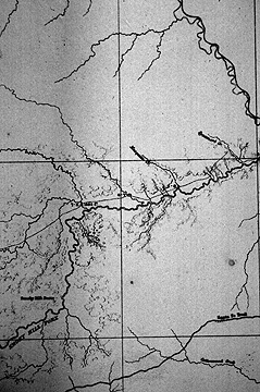
Figure 12: Detail, Map from Beckwith Survey, 1855
Egloffstein's surveys produced a skeleton map of the region which was then augmented with careful reference to the panoramas:
The circular views, of which the centers are occupied by the observer, ... were properly placed on the projected map, overlapped large sections of the same country, and, being on transparent paper, greatly facilitated the construction of the map from their centres, and had the advantage by their profiles of keeping constantly before the draughtsman vivid pictures of the country.
The relief depiction on the map is thus derived from the observations depicted on the panoramas:
In that part of the map embraced within the fully-shaded topography ... [t]he character of the slopes of the mountains and of their outlines in full, whether precipitous or gentle, and of the deep mountain chasms of the water-courses wherever they occur, and also the character of the summit of the mountains, whether rolling masses, sharp peaks, or serrated edges, is taken from nature, and if successful, will convey to the reader a correct idea of the country as seen by the observer (U.S. War Department 1855, v. 2, appendix B, 125.)
As with the panoramas, the maps also privilege "actual appearance to the eye" but extend beyond the situated view of the panoramas to a planimetric framework. In one sense it is this transformation and compilation into planimetric form that lends authority to the numerous observations of the survey. The authority of the map derived "from being combined into a single cartographic archive..." (Edney 1997, ch. 3, 13; Godlewska 1995). The implications are that the abstraction embodied in the map is the source of the authority of the surveys and the expeditionary process in general. Paul Carter suggests a similar perspective in his work on the early maps of Australia:
The map only gradually became flat and smooth, equally authoritative in every part: to begin with, it did not exist apart from the routes that scored it. It was not a collection of geographical objects imprisoned beneath the grid of latitude and longitude. It was closer to a picture or to the journal itself: its surface was littered with isolated trees, graphic outcrops of rocks with nothing behind them, and with descriptive comments... which far from being authoritative, recorded nothing more than the traveller's distant, one-sided impression as he reined in his horse and focussed his glasses on the haze (Carter 1989, 71).
Yet in the case of the maps for Beckwith, the map as "a picture of the journal itself" and the view from the route of survey was intentional and explicit: a situated view abstracted into planimetric form. It is possible to interpret this map as drawing as much authority from its explicit connections to the situated views from the route of survey as from its more abstract, planimetric form. Egloffstein made it easy for the viewer to trace the intertextual relations from map, to panorama, to situated perspective and back again. The existence of such explicit interconnections engenders authority; the authority of Egloffstein's map then depends on its situation within a representational barrage: the map is not the final authoritative synthesis, the hyperworld is.
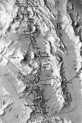
Figure 13: Detail, Rio Colorado of the West, 1858
The Beckwith panoramas reveal an artificial view from somewhere: an 180 degree sweep of the landscape "as it appeared" projected onto paper. The Beckwith maps take this one step further, to an artificial view from somewhere superimposed on a planimetric base. The purpose of Beckwith's survey - a proposed route for the Pacific Railroad - was well served by Egloffstein's maps of the view from the route of exploration. Ives' survey had a different purpose. While the Ives expedition travelled in a linear fashion, the purpose of the expedition was different - to investigate and define an area. Egloffstein's map provides the perfect statement of knowledge of a space required for Ives' survey. The conceptual distance between Egloffstein's map for Beckwith and his map for Ives is small, although their outward appearances may not immediately suggest this (figure 13). The idea of the situated view abstracted into map form developed on the Beckwith maps could be enhanced by filling in the entire map with situated views, accomplished via Egloffstein's "New style of topographic drawing." Egloffstein's map is, according to Ives, a "bird's eye view," "intelligible to every eye." The "magical" effects of the panoramic view transformed onto a map base simultaneously "truer to nature" and abstracted from it. Authority derives from the map's abstract, planimetric framework and, simultaneously, from its technique of shaded terrain: the entire shaded relief surface of the map an explicit symbol of its origins in special eyes, observation, and the view from somewhere.
Conclusions
"...spatial information gained from direct experience is more orientation free" ... "realistic [landscape] simulation is the nearest we can achieve to direct experience" ... "the opportunity for misinterpretation is limited if the image is ... a real world scene" (Bishop 1994, 61).
Bishop's recent comments on shaded digital terrain models mimic Ives comments on Egloffstein's Grand Canyon map in 1861, that this "method of representing topography is ... truer to nature. It is an approximation to a bird's eye view, and is intelligible to every eye" (Ives 1861, appendix D). Both Bishop and Ives have naturalized the way of seeing and knowing which allows for "realistic effects" derived from the "radical abstraction" of the shaded terrain image (Crary 1995, 9). There is a continuing fascination with "realistic landscape simulation" and shaded terrain maps, tethered to claims that such representations are "truer to nature," closer to "direct experience," and thus more "orientation free." Arthur Robinson has noted that "[t]here is something about the three-dimensional land surface that intrigues cartographers and sets it a little apart from other cartographic symbolization" (Robinson et al. 1984, 368). Indeed, the nature of such "radical" abstractions "allows them to replace the countryside itself in our understanding of space..." (Godlewska 1995, 24). This paper reveals how this innovative and spectacular way of seeing and representing came about by examining a particular historical exemplar in its scientific, cultural, and representational context. I suggest that the study of historical exemplars, such as Egloffstein's map, will help us to understand the historical roots of our current work, fleshing out the assumptions and methods upon which we depend although seldom articulate. Throughout this study I was struck by the manner in which the visual ways of knowing which dominate the story of Egloffstein's map and the Great Reconnaissance representational barrage dominate current thinking, discussions, and understanding in cartography and geographic visualization.
Egloffstein's map is examined as an early and unique example of the cartographic technique of relief shading. This paper provides evidence of the explicit link between situated views and the shaded terrain map: the view from somewhere abstracted into the "magical" panoramic form and then further transformed onto a planimetric base. My argument is that the authority and power of such representations of terrain derives from their basis in, and suggestion of, situated views. Thus the visual method of terrain shading symbolizes direct observation on its abstract surface, and direct observation serves as the basis of claims to the validity of the knowledge represented on such maps. Egloffstein's map at once embodies the abstract power of the map with explicit, visual evidence that this abstraction was derived from actual observations by a trustworthy observer. The basis in subjectivity and observation are explicit and necessary for the map to retain its authority.
The study of Egloffstein's map also reveals the intricate relations between maps and other representations in Great Reconnaissance reports, and their role as the conceptual framework upon which scientific knowledge was produced and communicated. Examining maps alone will miss much of their actual significance in the broader context of scientific knowledge production. I suggest that this complex of representations be understood as a hyperworld because the connections are not linear or one way. I argue against the perspective that would understand Egloffstein's map as the end of a developmental process, some kind of ultimate authoritative representation of terrain (Wood 1992). Both Godlewska (1995) and Edney (1997) delineate the interrelations of maps and other representations in their studies of the systematic surveys of Egypt (by the French) and India (by the British), yet both suggest the map as the ultimate model and "conceptual synthesis" of the surveys. I suggest, instead, that the abstraction of the map - as with scientific knowledge - derives authority from its origins in actual observation and the ability to both symbolize and trace back to actual observation. Thus the interconnected barrage of representations, the hyperworld of the published reports, rather than the map, serves as the conceptual model and synthesis of the surveys and their production of scientific knowledge: the means for envisioning the American West.
All of these characteristics depend upon a visual epistemology, drawn from European Enlightenment ideas. The assumptions and methods of such visual ways of knowing help to explain Egloffstein's Grand Canyon map, the hyperworld of the Great Reconnaissance reports, and their relation to the production of scientific knowledge. I suggest that we may use this historical knowledge to inform our development of visualization tools intended to aid in the production of current scientific knowledge. Hypermedia can be seen as a technological equivalent of the representational barrage in the Great Reconnaissance reports. Our use of hypermedia as a means and method for deriving geographic and scientific knowledge may be guided by the historical tradition of using such hyperworlds in the production of past knowledge.
Finally, by recognizing the historical roots and nature of the assumptions which underpin current work in visualization, we may also begin to understand critiques of and alternatives to visual ways of knowing. It is sometimes difficult to recognize the extent to which cartographers and geographers are dependent upon visual ways of knowing:
I recall an economist once telling me that the map was a theory which geographers had accepted (Ullman 1953, 57).
Geography is the only predictive science whose inner logic is literally visible (Bunge 1966, xiv).
Both Bunge and the economist quoted by Ullman suggest that geography itself is based on visual ways of knowing. That this visual epistemology may be problematic is noted by Marble and Peuquet:
Representation of information, particularly when freed from the constraints of a graphic structure, requires the investigation of the nature of the information structure from a purely logical standpoint. Presentation of information in ways that are not necessarily or exclusively visual is an area that cartographers ... have been ... reluctant to explore. (Marble and Peuquet 1993, 447).
Without recognizing the historical origins of the assumptions upon which cartography and geographic visualization are built we cannot begin to react to such critiques. Much work remains to be done to clarify the historical origins and current consequences of our visual epistemology. The analysis of Baron von Egloffstein's map, its scientific and cultural context, and its relation to a hyperworld of interrelated representations serves as a contribution towards understanding the basic assumptions of our current work in cartography and geographic visualization. Such historical studies help us to understand the origins, limitations, power, and consequences of our visual ways of knowing, may guide our attempts to provide new means of envisioning geographic and scientific information, and can assist us in recognizing and pursuing complementary alternatives.
Acknowledgements
Thanks to Denis Cosgrove and Alan MacEachren for comments on early drafts of this paper. Special thanks to Matthew Edney and David Woodward for their help with the Master's Thesis which was the origin of this paper.
Notes
Note 1: The reports were published in 1855 as Reports of Explorations and Surveys from the Mississippi River to the Pacific Ocean, 1853-54 (Senate Executive Document 78, 33rd Congress, 2nd Session). The Pacific Railroad Surveys remain somewhat obscure in the historical literature. In addition to the massive bound set of official reports and maps for the Surveys, see the following: G. Albright. 1921. Official Explorations for Pacific Railroads, 1853-1855. Berkeley: University of California Press; A. Frankenstein. 1976. The Great Trans-Mississippi Railroad Survey. Art in America 64(1): 55-58; Goetzmann (1979, 262-304); S. McKelvey. 1959. A discussion of the Pacific Railroad Reports as issued in the Quarto Edition. Journal of the Arnold Arboretum XL (1): 38-67; P. Russel. 1919. Analysis of the Pacific Railroad Reports. The Washington Historical Quarterly 10 (1): 3-16; R. Taft (1953): 254-269; P. Trenton and P. Hassrick. 1983. The Rocky Mountains: A Vision for Artists in the Nineteenth Century. Norman: University of Oklahoma Press: 67-95; Wheat (1957-63, Vol. 5, 67-91.
Note 2: Egloffstein's initial foray into the West was with the Fremont expedition of 1853-54. This expedition disintegrated early in 1854, due to poor weather conditions, near Parowan, Utah. While recovering in Salt Lake City, Egloffstein was hired by Lieutenant Beckwith, who was reorganizing the ill-fated Gunnison expedition which had lost numerous members, including artist and topographer Richard Kern, in an indian attack in October of 1853. See Brodhead (1976) and Krygier (1990).
Note 3: The background on Ives exploration can be found in his 1861 Report Upon the Colorado River of the West (U.S. House of Representatives Executive Document 90, 36th Congress, 1st Session, 1861; Reprint: 1969. New York: Da Capo Press). Preliminary reports were issued in 1858 as Annual Report of Captain A.A. Humphries in charge of Office of Explorations and Surveys (Washington DC: Government Printing Office, 31-42; 35th Congress, 2nd Session, vol. 2, Senate Ex. Doc. 1, Serial 975, 608-619; and 35th Congress, 2nd Session, House of Representatives Ex. Doc. 1, Serial 998, 608-619). Also see D. Miller. 1970. Balduin Mollhausen: A Prussian's Image of the American West. Unpublished PhD Dissertation: University of New Mexico; D. Miller. 1972. The Ives Expedition Revisited: Overland into the Grand Canyon. Journal of Arizona History 13(3): 177-196; S. Pyne (1982); H. Mollhausen. 1861. Reisen in die Felseng ebirge Nord-Americkas bid sum Hoch-Plateau von Neu Mexico. Leipzig: Herman Costenoble (a partial translation of this source is H.B. Mollhausen. 1948. Over the Santa Fe Trail. The Kansas Historical Quarterly. 16(4): 337-380). Reviews of Ives report in scientific journals can be found in: Anon. 1862. Colorado River of the West. American Journal of Science. 2nd Series 33 (99): 387-403; A. Geikie. 1870. Ca�ons. Nature. Feb. 24: 435-436; A. Hyatt. 1868. The Chasms of the Colorado. American Naturalist 2 (7): 359-365; Anonymous. 1859. The Colorado of the West. Debow's Review 1 (8) (new series): 282-286, provided a review for Southern readers; G. Roberts. 1863. The Great Ca�ons of the Colorado River. The Intellectual Observer 4 (5): 309-316 provided a review for European readers.
Note 4: National Archives MS, Record Group 48, Office of Explorations and Surveys, Correspondence Concerning the Colorado and San Juan Expeditions, 1861, Box 1.
Note 5: A collection of unsigned sketches on tissue paper glued in a scrapbook survives in the collections of the Newberry Library (Ayer MS 794a). These sketches have been attributed to Egloffstein, but instead seem to have been drawn by three different people: Mr. Schumann, the engraver of the thirteen panoramas in the Beckwith Report (who assembled the sketches and may have redrawn some of them), Egloffstein, and Richard Kern.
Note 6: This folio has been impossible to locate, although the technique it discusses is described in Appendix D in Ives (1861) and various patent materials documented in Horgan (1897) and Hanson (1993). Two primary references to the folio exist. The first reference is in The British Library General Catalog of Printed Books to 1975, London: K. G. Saur, 1981, volume 92: 264. Unfortunately, the copy in the British Library was destroyed during World War Two. The second reference to the folio is in an auction catalog for Alexander von Humboldt's library, noted in Henry Stevens. 1863. The Humboldt Library: A Catalog of the Library of Alexander von Humboldt. London: Henry Stevens, 193. The Stevens citation mentions that the folio contains a plate. It is likely that the copy of Egloffstein's folio in Humboldt's library was purchased by the British Library at the Humboldt auction and subsequently destroyed during WWII. V.W. Hagen. 1950. Was this the Fate of the Humboldt Library? Isis 41: 164-167.
Sources
Adams, P. 1962. Travellers and Travel Liars, 1600-1800. Berkeley: University of California Press.
Allen, J. 1975. Passage Through the Garden: Lewis and Clark and the Image of the American Northwest. Urbana: University of Illinois Press.
Anon. 1859. The Colorado of the West. Debow's Review 1(8) (new series): 282-286.
Barba, P. 1914. Balduin Mollhausen: The German Cooper. New York: Appleton and Co.
Bishop, I. 1994. The Role of Visual Realism in Communicating and Understanding Spatial Change and Process. In H. Hearnshaw and D. Unwin, eds. Visualization in Geographical Information Systems. Chichester: John Wiley and Sons: 60-64.
Brodhead, M. 1976. Edward Griffin Beckwith: Explorer of the Central Rockies. In F. Blackburn. Kansas and the West: Bicentennial Essays in Honor of Nyle H. Miller. Topeka: Kansas State Historical Society: 33-45.
Bunge, W. 1966. Theoretical Geography (2nd Edition). Lund Studies in Geography, Ser. C. General and Mathematical Geography No. 1.
Cannon, S. 1978. Science in Culture: The Early Victorian Period. New York: Dawson and Science History Publications.
Carter, P. 1989. The Road to Botany Bay: An Exploration of Landscape and History. Chicago: University of Chicago Press.
Cosgrove, D. 1984. Social Formation and Symbolic Landscape. Totawa NJ: Barnes and Noble.
Cosgrove, D. 1993. The Palladian Landscape. University Park, PA: Penn State University Press.
Crary, J. 1995. Techniques of the Observer. Cambridge: MIT Press.
Cronon, W., G. Miles, and J. Gitlin. 1992. Under and Open Sky: Rethinking America's Western Past. New York: Norton.
Culler, J. 1981. The Pursuit of Signs: Semiotics, Literature, Deconstruction. Ithaca NY: Cornell University Press.
Daniels, S. 1993. Fields of Vision. Princeton: Princeton University Press.
Duncan, J. 1993. Sites of Representation: Place, Time, and the Discourse of the Other. In J. Duncan and D. Ley, eds. Place / Culture / Representation. New York: Routledge: 39-56.
Dutton, C. 1882. The Tertiary History of the Grand Ca�on District with Atlas. Washington D.C.: U.S. Government Printing Office. (Reprint: 1977. Santa Barbara: Peregrine Smith).
Edney, M. 1997. Mapping an Empire: The Geographical Construction of British India, 1765-1843. Chicago: University of Chicago Press.
Godlewska, A. 1995. Map, Text, and Image. Transactions of the British Institute of Geographers NS 20: 5-28.
Goetzmann, W. 1978. Exploration and Empire: The Explorer and the Scientist in the Winning of the American West. New York: W.W. Norton and Company (reprint of 1966 edition).
Goetzmann, W. 1979. Army Exploration in the American West, 1803-1863, Lincoln: University of Nebraska Press (reprint of 1959 edition).
Goetzmann, W. 1986. New Lands, New Men: America and the Second Great Age of Discovery. New York: Viking Penguin Inc.
Hanson, D. 1993. Baron Frederick Wilhelm von Egloffstein: Inventor of the First Commercial Halftone Process in America. Printing History 15(1): 12-24.
Harley, J. 1987. Maps, Knowledge, and Power. In D. Cosgrove and S. Daniels, eds. Iconography of the Landscape. Cambridge: Cambridge University Press: 277-312.
Harvey, D. 1989. The Condition of Postmodernity. Cambridge MA: Blackwell.
Hillis, K. 1994. The Power of the Disembodied Imagination: Perspective's Role in Cartography. Cartographica 31(3): 1-17.
Horgan, S. 1897. General Von Egloffstein, The Inventor of Half-Tone. The International Annual of Anthony's Photographic Bulletin and American Process Year Book 9 (1): 201-204.
Humboldt, A. 1844. Cosmos. New York: Harper Brothers.
Humboldt, A. 1849. Aspects of Nature, In Different Lands and Different Climates. Philadelphia: Lea and Blanchard.
Imhof, E. 1982. Cartographic Relief Presentation. Berlin: Walter de Gruyter.
Irwin, D. 1976. The Historical Development of Terrain Representation in American Cartography. International Yearbook of Cartography 16(1): 70-83.
Ives, J. 1861. Report Upon the Colorado River of the West, Washington DC: Government Printing Office. (U. S. House of Representatives Executive Document 90, 36th Congress, 1st Session; Reprint: J. Ives. 1969. New York: Da Capo Press). Knight, D. 1986. Discourse in Pictures. In D. Knight. The Age of Science: The Scientific World-view in the Nineteenth Century. New York: Blackwell: 109-127.
Kraak, M. 1994. Interactive Modelling Environment for Three-dimensional Maps: Functionality and Interface Issues. In A. MacEachren and D. Taylor, eds. Visualization in Modern Cartography. Tarrytown NY: Pergamon: 269-285.
Krygier, J. 1990. The Landscape Images of Baron Frederick W. von Egloffstein, Topographic Artist in the American West, 1853-1859. Masters Thesis, University of Wisconsin Madison, Department of Geography.
Krygier, J. 1995. Cartography as an Art and a Science. Cartographic Journal 32(6): 3-10.
Latour, B. 1987. Science in Action: How to Follow Engineers and Scientists Through Society. Cambridge: Harvard University Press.
Latour, B. 1990. Drawing Things Together. In M. Lynch and S. Woolgar Representation in Scientific Practice. Cambridge: MIT Press: 19-68.
Lavender, D. 1982. Colorado River Country. New York: E.P. Dutton, Inc.
Livingstone, D. 1992. The Geographic Tradition. Oxford: Blackwell.
Livingstone, D. 1995. Towards a Historical Geography of Science. Environment and Planning D: Society and Space 13.
MacEachren, A., B. Buttenfield, J. Campbell, D. DiBiase, and M. Monmonier. 1992. Visualization. In R. Abler, M. Marcus, and J. Olson eds. Geographer's Inner Worlds: Pervasive Themes in Contemporary American Geography. New Brunswick: Rutgers University Press: 99-137.
MacEachren, A. 1995. How Map's Work. New York: Guilford Press.
Marble, D. and D. Peuquet. 1993. The Computer and Geography: Ten Years Later. Professional Geographer 45(4): 446-447.
Miller, D. 1970. Balduin Mollhausen: A Prussian's Image of the American West. Unpublished PhD Dissertation, University of New Mexico.
Mitchell, W. 1994. Landscape and Power. Chicago: University of Chicago Press.
Mollhausen, B. 1861. Reisen in die Felsengebirge Nord-Amerikas bid sum Hoch-Plateau von New Mexico. Leipzig: Herman Costenoble.
Monmonier, M. 1991. Ethics and Map Design. Cartographic Perspectives 10: 3-8.
Muehrcke, P. 1990. Cartography and Geographic Information Systems. Cartography and Geographic Information Systems 17(1): 7-16.
Nuti, L. 1988. The Mapped Views by Georg Hoefnagel: The Merchant's Eye, the Humanist's Eye. Word and Image 4(2): 545-570.
Pike, R. and G. Thelin. 1990-91. Mapping the Nation's Physiography by Computer. Cartographic Perspectives 8: 15-24.
Pyne, S. 1982. Dutton's Point: An Intellectual History of the Grand Canyon. Prescott: Grand Canyon Natural History Association.
Robinson, A. 1982. Early Thematic Mapping in the History of Cartography. Chicago: University of Chicago Press.
Robinson, A., et al. 1984. Elements of Cartography (5th ed.). New York: Wiley.
Rudwick, M. 1976. The Emergence of a Visual Language for Geological Science, 1760-1840. History of Science 14(1): 149-195.
Seavey, C. 1980. Exploration and Mapping of the Grand Canyon, 1859-1903. Bulletin: Special Libraries Association: Geography and Map Division 119: 4-15.
Schein, R. 1993. Representing Urban America: 19th Century Views of Landscape, Space, and Power. Environment and Planning D: Society and Space 11: 7-21.
Smith, B. 1985. European Vision and the South Pacific, 1768-1850. New Haven: Yale University Press (reprint of 1959 edition).
Stafford, B. 1984. Voyage into Substance: Art, Science, Nature, and the Illustrated Travel Account, 1760-1840. Cambridge: MIT Press.
Stam, R., R. Burgoyne, and S Flitterman-Lewis. 1992. New Vocabularies in Film Semiotics. New York: Routledge.
Stegner, W. 1982. Beyond the Hundredth Meridian: John Wesley Powell and the Second Opening of the West. Lincoln: University of Nebraska Press.
Stoddart, D. 1985. On Geography and its History. New York: Basil Blackwell.
Taft, R. 1953. Artists and Illustrators of the Old West, 1850-1900. New York: Bonanza Books.
Tukey, J. 1977. Exploratory Data Analysis. Reading: Addison Wesley.
Ullman, E. 1953. Human Geography and Area Research. Annals of the Association of American Geographers 43(1): 54-66.
U.S. War Department. 1855. Reports of Explorations and Surveys, to Ascertain the Most Practicable and Economical Route for a Railroad from the Mississippi River to the Pacific Ocean (Pacific Railroad Reports). Washington DC: Government Printing Office. (U.S. Senate Executive Document 78, 33rd Congress, 2nd Session, 1855).
Wallace, E. 1955. The Great Reconnaissance: Soldiers, Artists and Scientists on the Frontier, 1848-1861. Boston: Little, Brown and Company.
Watkins, T. 1969. The Grand Colorado: The Story of a River and its Canyons, American West Publishing Company.
Wheat, C. 1957-63. Mapping the Transmississippi West, 1540-1861, San Francisco: Institute of Historical Cartography.
Wood, D. 1992. The Power of Maps. New York: Guilford.
E-mail: jbkrygie@cc.owu.edu