


Historical Information about Peale Pennsylvania and the Tunnel Mines
Update: 5/26/00
Information about Peale and the nearby coal mines can be found scattered through published many published and unpublished materials, and those I know of are included below. Please let me know of any additional material similar to this and I will try and include it on this page. Newly added material is at the top of the page.
The Naming of Moravian Run
Exerpt from Cotohisc (Cooper Township High School), Winburne, PA, Discussing
some early Peale History and the origin of the name of Moravian Run, which
runs through Peale. (Vol. 10, No. 9, May 28, 1954). Contributed by Jennifer
Ertmer (avonlady@srt.net)
From "A Short History of Cooper Township"
Cooper Township is the youngest township in Clearfield County. Originally a
part of Morris Township, it became a separate township in 1884, and was named
after its first settler, David Cooper.
Long after the Revolutionary War the area which was to become Cooper Township
was still a vast forest filled with deer, bear, wolves, panthers, and many other
wild animals. A trail between the Indian villages at Lock Haven and Clearfield
crossed the Moshannon near Peale and passed through the township by way of what
was to become Kylertown.
In 1758 Frederick Post, a worker among the Indians, traveled this trail with
two indians on his way to Fort Duquesne. They camped overnight on an island in
the Moshannon near Peale. The island is now known as Post Island. In 1772 a
band of about a hundred Moravians, traveling from Bradford County to Ohio under
the Leadership of John Ettwein, passed over this trail. Some of the party died
on the journey and were buried near Peale by the small stream which is now called
Moravian Run.
Senator S. R. Peale: Obituary
The obituary of Senator S. R. Peale, after whom Peale was named.
Contributed by Wayne Batcheler (batchele@bellatlantic.net)
From the Lock Haven Express, August 3, 1910
ACCIDENT TO EX-SENATOR PEALE WHILE OUT HORSEBACK RIDING PROVES FATAL
Died in Local Hospital Tuesday Evening of This Week After Suffering
Intense Pain From Fractured Ribs and Internal Injuries---Deceased Was
One of Lock Haven's Most Prominent Citizens
Ex-Senator S. R. Peale, of this city, died Tuesday evening of this
week at 6:55 o'clock from the result of the accident he sustained while
horseback riding on the Sugar Run road Tuesday morning. His death
occurred at the Lock Haven hospital, where he was taken after the
accident happened.
Mr. Peale suffered very much during the day and grew weaker as the
day advanced from the shock he received. When thrown by his horse he
sustained internal injuries, besides having four ribs fractured. While
it was known that his condition was critical, his death was not expected
so soon. He was conscious up to within fifteen minutes of the time when
the end came, and his daughter, Miss Martha, was at the bedside of her
father when he died. The other members of the family had only shortly
before left the hospital for their home.
Senator Peale was a great lover of horses and had recently procured
a fine new horse from Irvin W. Gleason of North Bend. It was his custom
to enjoy a horseback ride when at home as often as possible, and
following this custom he started Tuesday morning for a ride up the Sugar
Run road. When near the farm of Joel Reish his horse reared up and then
fell with Mr. Peale underneath. About this time Joseph Whitehouse was on
his way to the farm of Adam Dickey, at the head of Sugar Run, riding a
bicycle. He discovered Mr. Peale along the roadside, near the Reish
home. He assisted Mr. Peale to sit up as best he could, and hurried to
the house of Mr. Reish for assistance. He procured a chair on which the
injured man was placed, and the latter requested Mr. Whitehouse to get
his horse, which had jumped a wire fence and stood in the field nearby,
and ride to the hospital and procure an auto to convey him to that
institution. He also requested him not to notify his family of the
accident until after he had reached the hospital. When Mr. whitehouse
reached the hospital Mr. Calvin Armstrong was notified and at once
started for the scene of the accident with his touring car, accompanied
by Miss Happersett, the superintendent of the hospital.
The senator was carefully placed in the auto and conveyed to the
hospital, where every attention possible was given him to relieve his
great suffering. Dr. George D. Green, the Peale family physician, was
immediately summoned and on examination discovered that four of Mr.
Peale's ribs were badly fractured. He also sustained internal injuries
and the shock he received was too much for a man of his advanced years
to overcome.
The death of Mr. Peale removes from this community one of its most
prominent citizens. He had been a resident of Lock Haven for 54 years
and during this more than a half century took a deep interest in the
welfare and advancement of the town. He keep in close touch with the
commercial, club, social, church and educational life of this city. He
also was identified with politics, not as an office seeker or for
political preferment, but for the good of the city, state and nation.
He came to Lock Haven when 26 years of age and at once began the
practice of law, having been admitted to the bar of Northumberland
county a short time before coming to this city. He became one of the
most famous land and railroad attorneys in this section of the state,
being contemporaneous with Senator William A. Wallace, Judge John H.
Orvis and other celebrated attornies.
In 1857, a year after he removed to Lock Haven, he was united in
marriage to Miss Harriet F. Alter, of Philadelphia, and their beautiful
home in this city, known as "Hillside," on North Fairview street, has
been the centre of attraction to a host of friends during all the years
of their happy married life. In September, 1907, they celebrated their
50th wedding anniversary, surrounded by their twenty-one children and
grandchildren. One of the features of the occasion was the informal
reception held in the afternoon, when scores of our citizens called to
pay their respects and extend hearty congratulations to the couple whose
lives have been an inspiration to the people of this community. They
have resided at "Hillside" for nearly 50 years.
Samuel Richard Peale was the son of Dr. John W. Peale, a practicing
physician, and was born at Hughesville, Lycoming county, Pa., September
20, 1830. The family lived at Hughesville until the subject of this
sketch was ten years of age, when they removed to Sunbury, where the
father practiced medicine. In 1850 S. R. Peale graduated from Dickinson
college at Carlisle and later studied law and was admitted to the
Northumberland county bar. He located in Lock Haven in 1856 and began
the practice of his profession. In the following year he was married to
Miss Harriet Frances Alter, of Philadelphia.
In 1876 he was elected to the state senate from the
Clinton-Centre-Clearfield district and served one term with distinction.
He declined a renomination from the Democrats, on which ticket he had
been elected. His successful career as a land attorney brought him into
prominence throughout this section of the state.
In 1881 he began purchasing coal lands in Clearfield county and the
following year bought many thousand acres of coal lands on Moshannon
creek, near Kylertown. Subsequently he interested with himself Hon. John
G. Reading of Philadelphia, and afterwards the Hon. William A. Wallace,
of Clearfield, and Hon. J. M. Gazzam, of Philadelphia, in his coal
transactions. The late William H. Vanderbilt was later led to purchase a
half interest in the lands and also with the building of the Beech Creek
railroad, with which project the deceased was so intimately connected,
to open up the new Clearfield bituminous coal fields. Mr. Peale was the
general solicitor of the new road from 1882 until 1895. He had charge of
the purchase of the right of way for the Beech Creek railroad. He was
instrumental in organizing large and prosperous coal interests
affiliated with the New York Central lines.
Deceased was of Scotch-Irish descent, his ancestors having settled
in Cumberland county, Pa., at the close of the eighteenth century. He
had been an active member of St. Paul's Episcopal church of this city
since 1860 and served as superintendent of the Sunday school of that
church for some time. He also taught a Bible class in the Sunday school
for years. He was the senior warden of St. Paul's church and had been
since the death of the late Paul S. Merrill in 1892. He is survived by
his widow and six children, as follows: Rembrandt, of the well known
coal firm of Peale, Peacock & Kerr, of New York city; John, also of New
York city, and Frank, who resides at Summit, N.J. but has law offices in
New York city; Mrs. Frank B. Towne, of Holyoke, Mass., and the Misses
Martha and Elizabeth, at home.
The funeral will take place Friday afternoon at 2:30 o'clock from
the Episcopal church. Interment will be made in Highland cemetery and
will be private.
A rich source of information on late 19th century Pennsylvania are the
publications of the Geological Survey of Pennsylvania. The Survey
published numerous tomes on all aspects of geology in the state of Pennsylvania -
focusing, of course, on resources such as coal, oil and gas, iron, and other
economically important materials. Many of these reports contain descriptions,
maps, and images of mines and mining communities in Pennsylvania. A Summary
Description of the Geology of Pennsylvania published in 1895 by the
Pennsylvania Geological Survey contains a map of Peale and the tunnel mines as
well as a brief description of mining activities in the area.
The descriptions of the mines in the Geological Survey Reports are focused
on details about the coal - its quality, thickness, and location. By default,
some cultural details are noted (but in the case of Peale, they are mostly on
the map).
"The Clearfield Bituminous Coal Co's. mines are the only other
merchantable area in the western part of the first coal basin along Beech Creek,
where about 300 acres of the Kittanning lower coal with neighboring small
remnants, having been caught on the high ground between the waters of Big and
Little Moshannon creeks, at the tunnel of the Beech Creek RR. In November, 1883,
the Clearfield Bituminous Coal Co. had located five drifts on this land, four in
the main body of 300 acres and one in the 50 acre patch on the hill south of the
tunnel. In places the bed shows its usual character, two benches 3' 1" to 4' 3"
thick, sometimes with streaks of sulphur and a lower bench 11' thick, the two
separated by about 8" of slate. In No. 3 drift there are no less than four
benches, 11', 2' 10", 6" and 10", although the two upper partings are mainly bone
and sulphur 6" thick, the main parting between the two lower benches being slate
about 10" thck. In drift No. 5 on the 50 acre patch there is an upper bench of
dull coal 2' 6" thick; a middle slaty coal 7" and a soft bottom coal 9", with
bone and slate partings of 1" and 8"." (reproduced from the 1895 Pennsylvania
Geological Survey Summary Report, vol. 3, pt. 2, p. 2199. The map is plate 408
between pages 2196 and 2197 of the same report. Both seem to have been
reproduced from the report of E. V. d'Invillers, Report T4, 1884).
Map of Peale and Tunnel Mines, ca. 1884. Click for a larger
version (enlarged from the original 4" by 2" map). Note the seeming
abundance of buildings along the road between Peale and the Tunnel Mines
to the east of Peale. Also notice the small bridge along the path from
Peale to the Tunnel Mines. There is no indication of a road from Peale
to Grassflat on this map, suggesting the Grassflat mines had not yet been
opened. Drifts 1, 2, 3, 4, and 5 are located on this map.
See below for detailed plans of these particular mines.
Peale in the Pennsylvania Department of Internal Affairs Annual Report for
1884
From 1872 until 1900 the Pennsylvania Department of Internal Affairs
published its Annual Report summarizing a diversity of data relating to
property and industrial activities in Pennsylvania. The Annual Reports
were issued in several volumes - Land Office (Boundary) Information, Assessments,
Industrial Statistics, Rail Roads, Canals, etc., and Coalmines, for example. The
1884 Annual Report contains information on Peale and the nearby Tunnel
Mines, including detailed maps of Peale and four of the Tunnel Mines. The
descriptions (below) are quoted from the text of the Annual Report for
1884, and the maps in the report have been scanned. It is possible that other
mentions of Peale and the local mines may exist in the reports for other
years.
Copies of the Pennsylvania Department of Internal Affairs Annual Reports
can be found in Penn State's Pattee Library.
The descriptions of the mines and villages in the Annual Reports are in the
form of a narrative. A State of Pennsylvaina inspector apparently visited the
various mines and related villages numerous times over the course of a year. The
description starts with a paragraph on the village of McIntyre in Lycoming
County.
McIntyre
"Visited these mines three times during the year, the first being December 26 and
27, and found things in fair condition. Again visited them May 21 and 22, and
found the ventilation in No. 4 mine improved, as a shaft had been put down near
the face of the workings. Mines Nos. 2, 3, and 8 were all confined to pillar
workings, and ventilation was good under the circumstances. I paid them another
visit August 7 and 8, and found drifts Nos. 2, 3, and 8 worked out, and the men
employed in No. 4 drift pulling back the gangway pillars. Everything was in good
shape at that time, and the mines were abandoned at the beginning of October, and
the men drafted to the new mines opened in Peale, Centre county. G.H.
Platt, general manager; Thomas Blyth, superintendent of mines." (p. 131a)
Tunnel Mines
"These mines, four in number, are owned and operated by the Clearfield Bituminous
Coal Company. G. H. Platt, general manager; Thomas Blythe, superintendent of
mines; John Charlton and George Bateman, mining bosses."
"Drifts are 26 feet wide and 7 feet in height. Headings are driven double and
laid with steel rails. The rooms are turned off single and pillars withdrawn,
when the room is worked up to the required distance. The coal will average three
feet in thickness."
"There is a furnace, 8 feet by 10 feet, in each drift; the average amount of air
passing over each furnace was 35,000 cubic feet per minute. No expense whatever
has been spared in opening these mines and providing ventilation, and those in
charge are to be commended for the pains they have taken to make their mines
models worthy of imitation."
"Over 400 men and boys are employed here, and the mines are producing from 800 to
1000 tons of coal per day."
"This coal is shipped over the Beech Creek, Clearfield, and South-Western railroad
and goes east from Newberry Junction, via the Reading system and north from
Jersey Shore, via the Pine Creek railroad and Corning, Cowanesque and Antrim
railroad. The B.C.C. and S.W.R.R is being rapidly pushed forward to the valuable
coal fields in Clearfield County, and will open up an immense body of coal lands
in that county." (p. 133a-134a)
The following maps were included with the above report. Click on the image to
get a larger image of the map. See the map of Peale and the Tunnel Mines (above)
for the location of these mines. A map showing the relationship between Peale
and the Tunnel Mines is included in Jeff Feldmeier's The
Beech Creek Railroad in the Peale, Pennsylvania Area.
The original map of Peale. Note the buildings shown on the map. It is not
clear if all of the buildings shown actually existed, or were planned. Note also
the notation (lower right corner) of the path to the Tunnel Mines.
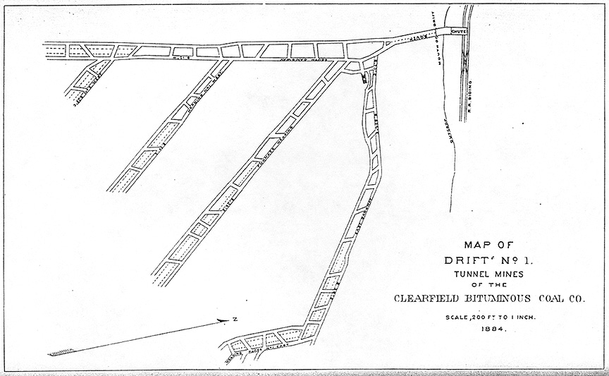
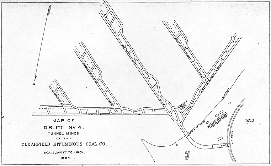
Drift No. 1 of the Tunnel Mines. Note connection to railroad siding.
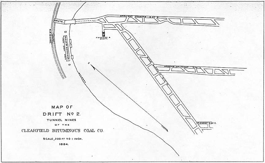
Drift No. 2 of the Tunnel Mines. Note the area marked "Block of Dwellings"
near the chute and RR siding. Apparently there were miners living near the Tunnel
Mines, as well as in Peale.
Drift No. 3 of the Tunnel Mines. Note a few buildings near the mouth of the
drift.
Drift No. 4 of the Tunnel Mines. Again, a block of dwellings, and some shops,
near the mouth of the drift.
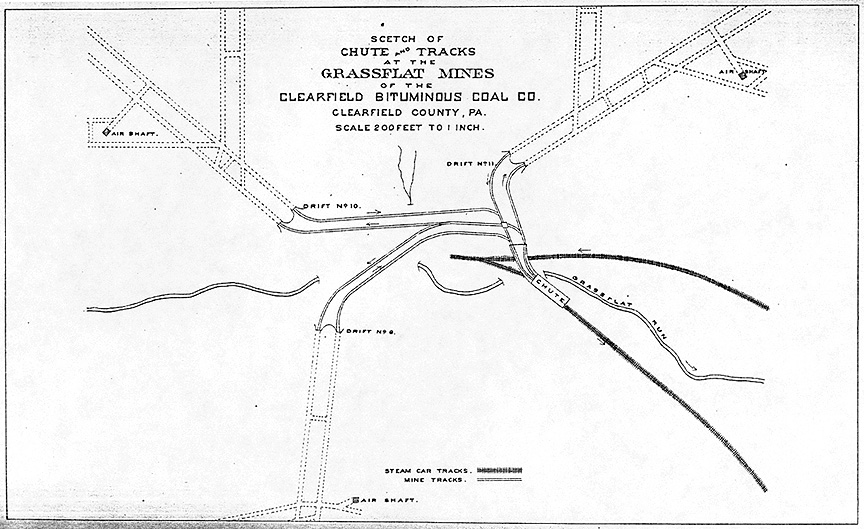
Grassflat Mines, Chute and Tracks. A map of Drifts 9, 10, and 11 in
Grassflat with Grassflat Run and the RR tracks.
Peale on U.S. Geologic Survey Topographic Maps (1922/1932/1939)
U.S. Geologic Survey Topographic maps can be very useful historical
'snapshots' of particular places. Highly detailed and systematic topographic
mapping of the US began in the latter half of the 19th century and continues
to date. Old USGS topographic maps of the area around Peale have been reproduced
below. They provide an inventory of roads, railroads, mines, and buildings
around Peale in 1922, 1932, and 1939 - in essence, as Peale faded away (prior
to its rebirth here on the WWW).
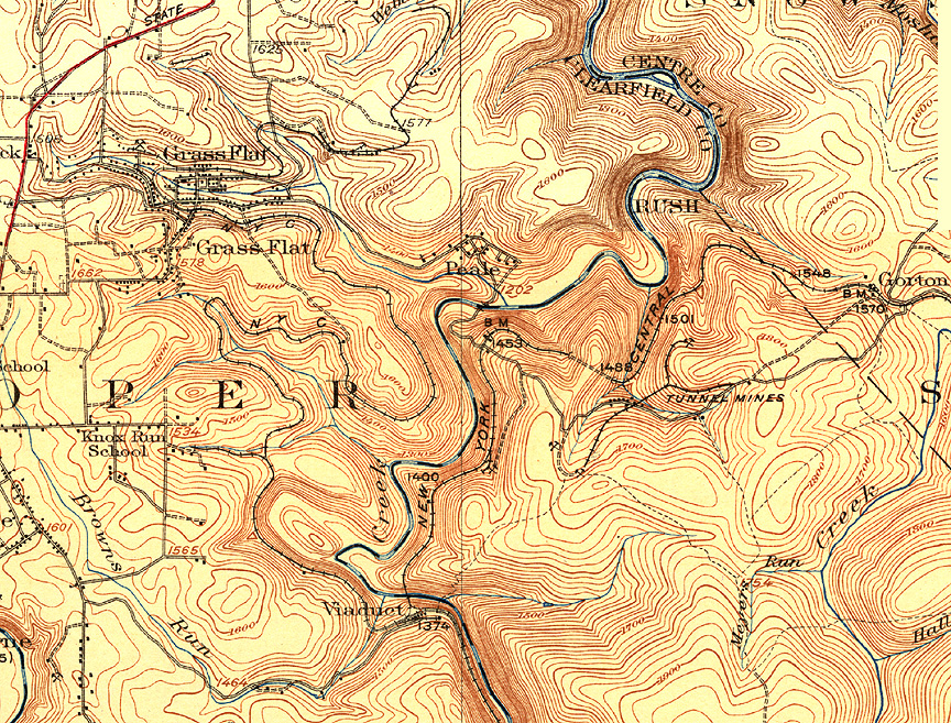
Composite: Karthaus 1:62,500 sheet (1932) + Philipsburg 1:62,500 sheet (1922)
Click on the map for a larger version
The division between these two map sheets can be seen running left-right just
north of Peale. The top map sheet (Karthaus) was created in 1932. I could not
find an earlier edition of this map sheet (this one may be the first). Note the
bustling metropolis of Grass Flat and the various mines. The lower map sheet
(Philipsburg) was created in 1922. Note that a church is located on the west
side of Peale, above the road. There are also fifteen other buildings, probably
houses, in Peale. Also notice Viaduct (to the south) and Gorton (to the East).
The Tunnel Mines are noted, as is a rail connecting them which seems to be
disconnected from the main line of the Beech Creek RR.
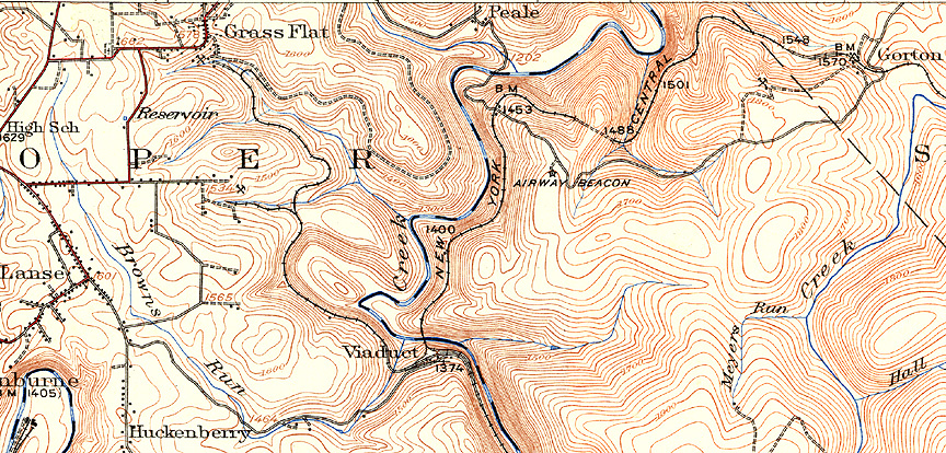
Philipsburg 1:62,500 sheet (1939)
Click on the map for a larger version
I have included only the Philipsburg map here, as I have not found a later
edition of the Karthus map. Notice that the church shown on the 1922 map
on the western side of Peale is gone, as are all but six of the buildings.
The Tunnel Mines are all but abandoned. Later maps will show the area around
the Tunnel Mines stripped for coal.
Please contact j.b. krygier
(jbkrygie@cc.owu.edu) with comments, input, or additional
information.
Contents...
Introduction: The Ghost Company Town of Peale, Pennsylvania
Interpreting the Geographies of Peale
The Beech Creek Railroad in the Peale, Pennsylvania Area
Peale Pennsylvania Manuscript Census
Project Peale: A Guerrilla Art Project
>>>>Historical Information about Peale and the Tunnel Mines
Kyle Crichton: Peale's Most Famous Son?
Directions to Peale, Pennsylvania
E-mail: jbkrygie@cc.owu.edu
Peale in the Geological Survey of Pennsylvania Publications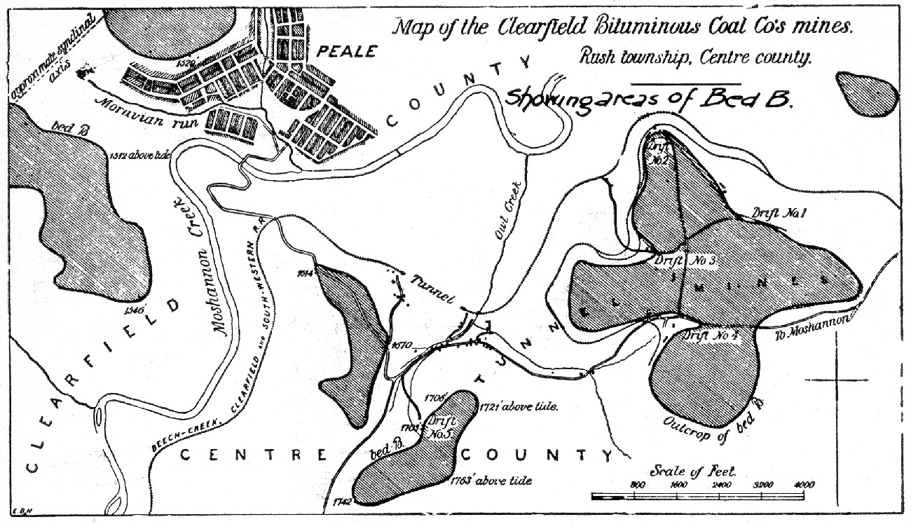
The Maps: Peale, the Tunnel Mines, and Grassflat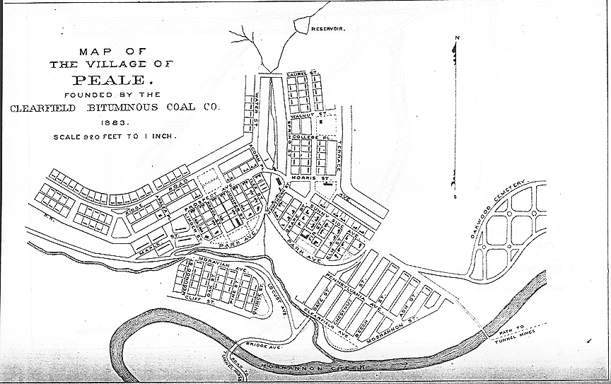

 These pages comprise an ongoing project to document,
map, interpret, and memorialize the ghost company town of Peale
Pennsyvania located along the Clearfield and Centre County (PA) boundaries in
north-central Pennsyvlania.
These pages comprise an ongoing project to document,
map, interpret, and memorialize the ghost company town of Peale
Pennsyvania located along the Clearfield and Centre County (PA) boundaries in
north-central Pennsyvlania.