


Interpreting the Geographies of Peale, Pennsylvania
by Casey McCracken and J.B. Krygier
Copyright Casey McCracken and J.B. Krygier, 1999.
The village of Peale is a continuum of material places ranging from the despoiled landscape of today back through the wilderness that preceded the town. Thus Peale can be seen as an archeology of material artifact set down in layers, each obscuring those beneath. But Peale also exists as an archeology of ideas. Peale occupies a place at the intersection of various discourses of the late 19th century. The town came about in the context of the rise of industrial capital and the assertion of a new mode of production. Attendant with such structural changes were wrenching transformations of social life. Social relations had steadily eroded in the latter half of the 19th century, and people, not fully comprehending the nature of their changing world, struggled to define new identities as new social relations evolved.
Peale cannot be one story told in one voice, for it was and is many stories. This is not to say that there are different views of the same place; instead, the place consists of fundamentally different experiences of the world. The people of Peale, those who arose at dawn, pulled on their boots and their moleskin trousers and lugged picks and shovels to the coal mines, related to Peale in a different way than those who owned and controlled the town. Only the voice of the latter has been set down, and historical description tends to reiterate this one voice. It lends itself to a dimensionless, determined representation which leaves no space for the lives and voices of the people who used the privies and wore their shoes out on the rocky streets.
Conception... from an idea that never occurred to anyone, to a vague possibility...
Circumstances played out in distant places enabled the idea of Peale to take root. In the 1870s the Pennsylvania Railroad (PRR) was developing its coal lands in Clearfield and Centre Counties, and it had plans for the Moshannon Creek. The PRR postponed these projects and the Moshannon coal lands attracted the interest of other men in desperate need of fuel resources: the major industrialists of New York State. Many already held coal lands in Tioga County Pennsylvania which had fulfilled their energy needs, but were also rife with conflict between labor and capital.
Four companies dominated Tioga County coal. Blossburg Coal Co. belonged to Erastus Corning. His Tioga RR shipped coal from the company town of Arnot to Corning where it fueled the Erie RR. Morris Run Coal Co. shipped over the same line to Watkins where it proceeded by barge on the Finger Lakes to the Onondaga Salt Works in Syracuse. Fall Brook Coal Co. was the enterprise of John Magee, also of Watkins. Fall Brook, in conjunction with the New York Central RR (NYCRR), opened a town and mines in Antrim and shipped coal north along a route controlled by the NYCRR. Finally, the McIntyre Coal Co., owned by Jervis Langdon and J.D. Slee, produced coal for delivery via the PRR's Northern Central to Elmira NY.
For the Vanderbilts and their NYCRR, "the purchase of fuel, always and outstanding expense, had not loomed as a difficult problem...but gradually it became one." By the 1880s the Fall Brook and McIntyre mines were nearly exhausted. Tioga County coal could not meet growing demands for fuel, the independent operators in Tioga County could not effectively confront the irrepressible labor movement. All parties were looking for new territory.
Gradually, and for a variety of reasons, the various New York interests came to the realization that the future lie in the west, in the district controlled by the Pennsylvania RR. The New York coal operators had run into labor troubles and were running out of coal. Having to purchase additional coal on the open market, Vanderbilt (NYCRR) officials became alarmed at Pennsylvania's coal barons' belligerence in negotiating coal prices. They resolved that their future lay in direct ownership of coal lands in central Pennsylvania and in cooperation with their erstwhile rivals in Tioga.
Incipient Notions...in which necessity is the mother of strange bedfellows...
For the foray into central Pennsylvania coal to be successful, New York coal operators needed the financing of industrialists like the Vanderbilts. At the same time, the Vanderbilt's NYCRR depended upon independent coal companies to provide an innocuous corporate front to penetrate into the heart of the PRR's domain.
A coalition of New York coal operators and railroad barons, led by Vanderbilt, took control of 33,000 acres of coal lands in Centre and Clearfield Counties. The investment was made through the McIntyre Coal Co., which became the mucus of the NYCRR's coal developments in Pennsylvania. In December 1882, a new company was chartered as the Clearfield Bituminous Coal Company (CBC) and its list of directors and investors included: Wm. and Cornelius Vanderbilt of the NYCRR; Jervis Langdon, Wm. Kelly, and J.D. Slee of Elmira, directors of McIntyre; G. John Magee of Watkins, director of the Fall Brook Coal Co.; and John Lang of Corning, director of the Blossburg Coal Co. Other notable participants in the venture were Samuel Clemens of Elmira and two ex-senators from Pennsylvania, Wm. Wallace of Clearfield and S.R. Peale of Lock Haven. Wallace and Peale were critical operatives in the scheme. Peale explained: "for more than a year, I have been acting in conjunction with others interested in Centre & Clearfield County coal lands to secure the desired transportation for our coal." He was referring to his role in establishing rail transportation for the CBC.
In August 1882, a group of Pennsylvania men led by Wallace and Peale had chartered the Susquehanna & SW RR (Beech Creek RR). The route for this line was the same as that surveyed and controlled by the PRR since 1874. The Beech Creek RR pursued a two prong strategy to occupy the route before the PRR exercised their options on it. First , to establish the route quickly, they hired the surveyor who had done the work 8 years earlier for the PRR. On the other front, Wallace sought and won an injunction of restraint prohibiting the Pennsylvania RR from occupying the route. The way had now been legally cleared for the representatives of the NYCRR to penetrate deep into the heart of the PRR's domain. The idea of Peale began to take definite form. The corporate design was in place and attention turned to the particulars of extracting coal from the Moshannon.
Realization...in which the material formation of Peale takes tangible form...
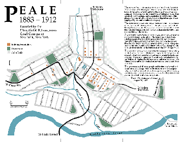
Map copyright J.B. Krygier, 1998.
Map of original Peale street plan with contemporary features. Note: this
map was taken from a printed brochure and has not been optimized for the WWW.
Click on the image to get a larger version (100k).
In 1883 the Beech Creek rail line was bid out, and in the spring of 1884 the CBC. began the work of building a model community on the steep slopes of the Moshannon Valley. Construction was directed by George Platt, the former General Superintendent at McIntyre. He planned a community complete with tree lined boulevards with lofty names; public spaces; street corners marked by majestic grandfather oaks; and a sinuously-laned cemetery.
The company recruited many of the families from the McIntyre Mines to inhabit this new city and work in the Moshannon mines. The social relations of the McIntyre system were replicated in Peale, though the form of the town itself was new. Its builders (owners) represented Peale in terms of a bucolic landscape with contented workers (see the contemporary description from The Raftsman's Journal in the introduction to these pages), yet it afforded them the complete social control they sought.
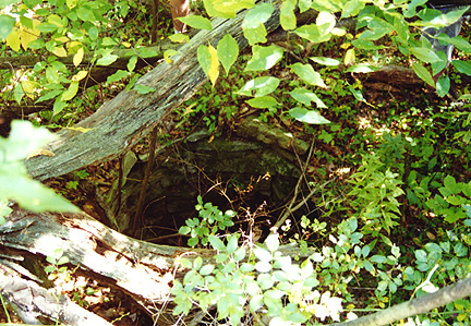
Stone lined well in Peale. Similar wells can be found in McIntyre - a related Pennsylvania ghost town in Lycoming County.
How the miners represented Peale, and their lives there, are lost to us. Their legacy is left in the landscape. The miners from McIntyre set about clearing the boulder strewn ground and building the stone animal pens and rock-lined wells on Moravian Hill the way they had in McIntyre and, before that, in Europe. The vacant cellar-holes of the houses are marked by the barberry bushes, apple trees, and feral flowers once confined to tidy beds.
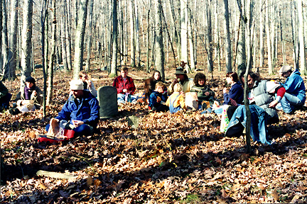
Lunch with Martha Renfrew: her lone grave stone marks the location of Peale's cemetery. Other grave markers in the cemetery were wood (according to information supplied by Jennifer Ertmer) and have not survived.
The cemetery, a text of the ideas of absent owners sketched upon the rocky landscape, was supplanted by another smaller, simpler design written by the distraught families of those who grew old and tired or were crushed in the mines. This practical burial ground cleared of the larger boulders lay atop the romantic memorial garden. Its inhabitants, residents of Peale, lie silently in rows that define the contours of the hill; all unmarked, save one, except by the subtle depressions that collect the autumn leaves. The remaining marker, that of Martha Renfrew who died the 18th of May 1886, is the single written text recording a voice of Peale: "I was."
 These pages comprise an ongoing project to document,
map, interpret, and memorialize the ghost company town of Peale
Pennsyvania located along the Clearfield and Centre County (PA) boundaries in
north-central Pennsyvlania.
These pages comprise an ongoing project to document,
map, interpret, and memorialize the ghost company town of Peale
Pennsyvania located along the Clearfield and Centre County (PA) boundaries in
north-central Pennsyvlania.
Please contact j.b. krygier (jbkrygie@cc.owu.edu) with comments, input, or additional information.
Contents...
Introduction: The Ghost Company Town of Peale, Pennsylvania
>>>Interpreting the Geographies of Peale
The Beech Creek Railroad in the Peale, Pennsylvania Area
Peale Pennsylvania Manuscript Census
Project Peale: A Guerrilla Art Project
Historical Information about Peale and the Tunnel Mines
Kyle Crichton: Peale's Most Famous Son?
Directions to Peale, Pennsylvania
E-mail: jbkrygie@cc.owu.edu