


Public Participation Visualization: Conceptual
and Applied Research Issues
There are numerous overlapping issues and topics which inform the design, implementation, and evaluation of PPVIS. This page attempts to describe these diverse issues, provides links to WWW-based resources, and some of my evolving research questions. It consists of preliminary ideas (and some links) in progress and will be continually updated. The issues are in reference to a prototype WWW-based GIS and visualization site designed for the Lower West Side of Buffalo. The design and implementation of this site is documented in Keng-Pin Chang's thesis The Design of A Web-based Geographic Information System for Community Participation. The issues:
Site Use and Design: Geographic Visualization and Cartography Cubed
The Medium: Representation, the Visual Forms, and Hypermedia
Public Participation and Information Technology
The Social Aspects of Information Technology
Access to Information Technology (and WWW-based Mapping/GIS)
Information Technology in Urban and Rural Places
Information Technology and Marginalized Communities
Site Use and Design: Geographic Visualization and Cartography Cubed
Geographic visualization can be defined in terms of the way maps (and other visual representations and media such as the WWW) are used. Alan MacEachren has conceptualized such use as a three-dimensional space (graphic). This conceptualization is useful as it provides a means of organizing the different ways the Lower West Side (LWS) site can be used, and thus can guide the design and implementation of the site. This space consists of three interrelated continuua:
Some examples:
Private use: Individual in community uses on-line mapping utility to view map of absentee-landlord owned homes and map of housing violations in neighborhood. This type of use suggests the on-line mapping capability and any other aspects of the site must be designed so they are useful to a broad range of individual users and uses. There will also be a distinction between the use of on-line mapping and gis by community planners and the use by the general public. A list of specific, private uses of the WWW site will be generated.
Public use: The site used by Buffalo city officials to evaluate current community issues and concerns, or by people outside of the community interested in its retail and entertainment attributes. This type of use suggests a careful design which represents the community and its human diversity in a manner which is easy to use.
Revealing unknowns: A user compares and contrasts maps of absentee-landlords and housing violations, seeking any visual correlations of these two maps. The user examines maps of prostitution arrest sites along with the address of "johns" to see where the consumers of prostitutes live in the Buffalo region. This type of use suggests a basic understanding of hypothesis testing, and the site should be designed to allow and encourage such queries.
Presenting knowns: The site represents the diverse history of the neighborhood, the current retail and entertainment attributes of the community, or community problems (such as concerns with gating parts of the community, prostitution, drugs). This type of use suggests a careful design which represents the various problems and prospects of the community, which is also sensitive to the diverse range of people in the community.
High interaction: The site contains interactive mapping capabilities and the capability for users to add information via the internet. This requires advanced technological support and is one of the primary technological challenges of this site. K. Chang evaluated the software, hardware, and personnel requirements of such functionality (The Design of A Web-based Geographic Information System for Community Participation.).
Low interaction: The site has different parts (history in word and image; "virtual fieldtrip" with sights and sounds of the neighborhood, etc) which can be viewed and read without more advanced interaction.
A list of specific users and uses of the Lower West Side site will be generated to help with the design and implementation of the site.
The Medium: Representation, the Visual Forms, and Hypermedia
The use of the WWW allows for the site to incorporate a range of visual forms (images, maps, graphs and other abstract diagrams) as well as text and sound. The interrelations between these representational forms are significant and must be carefully considered, particularly since the medium of hypermedia (and the WWW) allows explicit interconnections. However, this is not only a simple exercise in cobbling together text, visual representations, and sound. Geographers (including Edward Soja, Andrew Sayer, Alan Pred, and Martin Lewis) have discussed the limitations of words as a means of representing the simultenaety and spatiality of social life. The broad range of representational forms provided by hypermedia and the WWW, when critically constructed, may serve as a solution to the limits of text in representing a community in all its complexity. Add to this the diverse ways of using and interacting with such information (from lower interaction viewing of information as presented to high interaction modification of development of on-line information) and we move towards a much more sophisticated means of representing the geographies of community and place.
A practical way to organize and understand the various representational issues is with a resource typology described in the paper by J.B. Krygier et al. entitled "Design, Implementation, and Evaluation of Multimedia Resources for Earth Science Education" published in the Journal of Geography in Higher Education, 21:1, 1997. pp. 17-39.
The resource typology consists of two dimensions (see figure 2 below). The first consists of a range of representational forms, including imagery, maps, diagrams, graphs, and tables. The second dimension encompasses a range of resource functions.
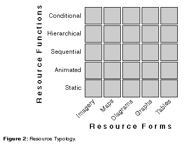
Resource forms are relatively easy to understand, and can be supplemented with additional forms such as sound and QuickTime VR. Resource functions can be defined as such:
Static resources include images, maps, diagrams, graphs, and tables that do not require interactive performance.
Animated resources express change or motion when activated by the user. Interactivity is limited to starting and stopping the resource. Animated maps and diagrams are useful in representing phenomena over time.
Sequential resources allow the construction a linear sequence of elements one component at a time through a series of button clicks. The difference between an animation and a sequential resource is one of control over the materials being presented. A sequential resource requires interactivity by the user in order to construct, step by step, an understanding of some final idea or concept.
Hierarchically nested resources are embedded with hidden information that can be revealed by selecting linked information in the initial display. Hierarchical resources move away from a linear construction of an idea or concept to a nonlinear means of exploring the depth of information embedded in a particular concept.
Conditional resources produce a graphic or numeric solution, according to the rules of an underlying algorithm, in response to the user's manipulation of an initial display. Conditional resources respond to the particular desires of the user and are not limited by either a sequential or hierarchical framework. Conditional resources provide a different kind of information than sequential or hierarchical resources, focusing on "what if" types of interactions rather than the construction of concepts (linearly with sequential and non-linearly with hierarchical resources).
This general framework will be modified to array the range of forms and functions useful in the Lower West Side WWW site.
Public Participation and Information Technology
The public, broadly defined to include individuals, companies, organizations, etc., has long participated in the decision-making process for a variety of environmental, social, and other issues. Information technology, including WWW-based mapping and gis, will certainly play an important role in such public participation in the future.
For a useful overview (with examples) and approach to community-based decision support systems see Michael Shiffer's "Community-Building Communications Technologies and Decision Support Systems." Shiffer's paper corresponds in important ways with the ideas detailed above in the "Site Use and Design" section.
Some research issues (in no particular order) include:
The archival role of information technology in the decision making process: past decision making processes are documented and available on-line, as are the experiences of other communities. Thus past experiences and the experiences of others can be used to inform current decision-making situations.
The facilitation of public oversight: can information technologies be used by the public to check up on what is happening after a decision is made (post-decision participation)? For example, public-access via the WWW to the output from an incinerator.
Not everyone benefits from sharing information. There is assumption that sharing is good (particularly among academics). Who won't share information and why? Who won't participate because participating might be detrimental?
Disbenefits of participation: What if too many people participate and bog down the process? What if not enough people participate? How to design public participation experiences to balance between these two extremes? Does access to the decision making process via remote locations (eg., at home) via the WWW have a detrimental effect on "community"?
The role of ridicule in the decision making process: An idea noted by Mark Monmonier (SYRACUSE), who argues that ridicule plays an important role in debates over contentions public issues. This is an important issue: for example, an environmental or community group may be able to defeat a development proposal by ridiculing the advanced information technologies (such as GIS) used to promote the pro-development perspective. This is similar to other neo-luddite attacks on information technology, and suggests that information technology will at most be a part of the decision making process, and could be bypassed altogether.
Non-threatening graphics: A really cool idea noted by John Felleman (SUNY ESF). Felleman (and others) have noticed that public participation in traditional settings (eg., meetings) can be diminished if the graphics used to present information about alternatives look too finished, polished, and set: it looks like the graphic represents a done deal, rather than one possible alternative. Felleman and others have suggested more sketchy and less finished looking graphics encourage public participation: the images look like the proposal is still in the "sketchy" stages. The same phenomena was noted by Alan MacEachren in his book How Maps Work (Guilford, 1995, p. 456). The issue of non-threatening graphics is closely related to the issue of "The Medium: Representation, the Visual Forms, and Hypermedia" discussed above. Several important issues are raised here:
The Characteristics of Non-Threatening Graphics: delineation of what is threatening and what is not. A preliminary list of possible characteristics is noted below and are culled from a variety of sources and most assume an info-tech based process; these could be evaluated in a more formal manner.
Evaluating Non-Threatening Graphics: Do the above characteristics actually hold up under evaluation? How would you design an experiment to evaluate such graphics?
The Usefulness of Threatening Graphics: An issue raised by Joel Morrison (USGS) at the Project Varenius meeting when the issue of non-threatening graphics came up: (I paraphrase): "Sometimes threating graphics are necessary." This perspective is interesting in that it opens up an area of inquiry: how are threatening graphics used by government agencies, planners, etc. in the "public" decision making process to ensure what they (as the "experts") want done gets done? Indeed, are public debates and decisions in part fueled by dueling threatening graphics? This is exactly the perspective of Bruno Latour in his chapter in M. Lynch and S. Woolgar's Representation in Scientific Practice (MIT Press, 1990) and links public participation to broader debates about the politics of representation. I deal with this issue in my research on the public debates over Project Ketch in Pennsylvania.
The Social Aspects of Information Technology
Technology is conceived as more than mere machinery. It is important to understand any existing technology (such as the WWW and information tech) as a product of a particular set of social conditions which will both shape and in turn be shaped by the context within which it is used. Careful attention must be paid to the manner in which technology changes and is changed as it is used in community settings.
It is also important to understand that technology in this case is more than computers and software. For example, the process of individuals in a community going door-to-door collecting information about housing conditions and the technologies (pencils, paper, etc.) used are fundamental in the context of community networks and the construction of a WWW site. Such "low" technologies are particularly important in lower-income communities.
An overview of the social issues embedded in information technology is discussed in "Culture, Society, and Advanced Information Technology" provided by the Computer Research Association.
Work is currently underway defining the range of technologies useful in the Lower West Side project, as well as means of assessing the role such technologies will play in the community.
Access to Information Technology (and WWW-based Mapping/GIS)
The Telecommunications Act of 1996 requires affordable, universal access to new information technologies. Many issues of access and use of such technologies - particularly in lower-income and other marginalized communities - remain relatively unexamined. Can members of a community afford to devote a significant portion of their resources to the purchase of a personal computer? What are the strategies for doing so? Can various locations in the community provide access to personal computers? What are the roles of schools, libraries, economic development corporations, and private sources? What are the educational needs for the use of such technologies? And finally, what are the advantages and disadvantages of access, and the advantages and disadvantages of the lack of access?
A discussion of general issues related to access can be found at the Virtual Information Institute site.
The provision of WWW-based mapping and GIS functionality is certainly part of this access issue. The primary problems are accessibility and affordability: how to deliver the functionality of mapping and GIS to individuals and communities. The primary alternative to WWW-based mapping and GIS is traditional microcomputer based software and hardware installations. Providing mapping and GIS functions on microcomputers in urban community centers has been investigated, but such physically located resources are difficult (if not impossible) for individuals in rural areas (and disabled and elderly individuals) to access due to time and distance considerations. Delivery of such mapping and GIS via the WWW is vital as it could maximize public access to mapping and GIS, and may be the most cost effective means of providing people in marginalized communities and regions with analytical tools which would not otherwise be affordable. Further, familiarity with the user interface provided by the WWW may enhance useablity. Users could focus on learning about the substantive use of mapping and GIS to solve problems, rather than struggling with an unfamiliar computer interface. Finally, the WWW provides easy access to excessive additional on-line information which may supplement and enhance particular applications of WWW-based mapping and GIS.
Some of these issues are discussed at the Public Participation GIS (PPGIS) site.
K. Chang's WWW-based Mapping and GIS Links provides links to examples of on-line mapping and GIS as well as discussions of how such functionality is being implemented for the Lower West Side of Buffalo. Chang has also completed The Design of A Web-based Geographic Information System for Community Participation..
Information Technology in Urban and Rural Places
A general literature on information technologies and their relation to urban and rural places and communities has developed in the last several years. Major books include:
Stephen Doheny-Farina. The Wired Neighborhood. (Yale, 1996)
Stephen Graham and Simon Marvin. Telecommunications and the City: Electronic Spaces, Urban Places (Routledge, 1996)
Douglas Schuler. New Community Networks: Wired for Change. (Addison Wesley, 1996)
Many on-line resources are also available. An excellent on-line overview of urban information technology issues (with associated links) is Shaping our Communities: The Impacts of Information Technology on Cites. The KickStart Initiative is sponsored by the Benton Foundation and is aimed at helping communities connect to the information superhighway. The NCGIA has sponsored a conference on "Spatial Technologies, Geographic Information, and the City."
Information Technology and Marginalized Communities
Related to the issues of information technology in urban and rural places and access is the issue of the availability and use of information technologies in marginalized communities. Several different kinds of marginalized communities exist in both urban and rural areas. Marginality can be due to economic and class distinctions (eg., poor inner-city or rural areas), race distinctions (black, hispanic, etc.), gender distinctions, sexual distinctions (eg., homosexuality), etc. These marginalized groups and places relate to information technology in complex ways. Some relate to real geographies (such as the Lower West Side of Buffalo) while others relate to virtual geographies (access to and representation on the WWW will allow the Lower West Side of Buffalo to be part of a virtual community of communities - and in particular low income communities - on-line).
The issues surrounding information technology in marginalized communities are diverse: from the practical (such as providing access to computers and the knowledge needed to use them in places with few resources) to the applied (such as the relation of information technology to community economic and social revitalization projects) to the political (such as community activism) to the representational (how to balance the representation of problems with the representation of what is good about a community) to the academic (issues important to social and urban geographers, urban studies, sociology, etc.).
A good overview of such issues were discussed at the Colloquium on Advanced Information Technology, Low-Income Communities, and the City sponsored by MIT. This colloquium resulted in a book published by the MIT Press.
A profile of the Lower West Side of Buffalo and its relation to Buffalo, Western New York, New York State, the U.S. and the World is under preparation.
Site Content
The actual content of the Lower West Side site will be diverse and changing. It will reflect the interests of different elements in the community, history, current issues, etc. One way to organize the diversity of topics, conceived of as different ways of looking at the information at the site, is through a basic set of categories which can also be used to organize the site itself:
Time/History: time is a traditional way of ordering information in a narrative or study of a place, region or landscape and will be one important way of organizing information at the site. There are concerns in the geographical literature that a dependence on temporal ordering alone may cause some "teleological" problems (where the assumption is that there is some ultimate and natural goal toward which a place, region, or landscape is evolving) so other ways of organizing the information are available. Possible topics include:
Space/Landscape: it is also possible to organize information in terms of space (rather than time). For example, a historical narrative in words can be replaced by a historical map where the user can click on sites on the map to get historical information about the clicked-on location. In a broader sense, the use of visual and 'spatial' representations allows for the representation of multiple scales and elastic boundaries of the "region" which helps to get away from the strict, physical conception of boundaries and single scale of analysis. It is possible to organize the way you look at a place from local to global scales, a more spatial way of understanding the place. Possible topics include:
Projects: organization of information around the collection of activities which shaped and continue to shape the community. These projects can be past events, current community events, or future events. The projects can be things that have happened (or are happening) largely independent of the WWW site or projects that are directly related to the WWW site. Possible topics include:
People/Groups: one can also examine the place in terms of different groups of People comparing different experiences - blacks, women, etc. - and relating it to the place and its characteristics. Possible people/groups include:
An agenda for which of these to focus on will be worked out in tandem with community members, through 1998.
Evaluation
The evaluation of a community WWW site is complex. For the Lower West Side project, evaluation will be conceived of broadly, consisting of four (often interrelated) functions: goal refinement, documentation, formative evaluation, and impact evaluation. Goal refinement consists of a detailed plan of action and set of goals; documentation is just that - documenting what is actually done in the process of creating the site; formative evaluation consists of the systematic collection of information during the process of creating the site in order to get preliminary feedback on its viability; and impact evaluation consists of the evaluation of the final site. Each of these evaluation functions can be facilitated with a range of evaluation methods, including interviews, focus groups, questionnaires, observations, ratings assessment, expert review, and achievement tests (a range of both qualitative and quantitative methods). This approach to evaluation is discussed in J.B. Krygier et al. entitled "Design, Implementation, and Evaluation of Multimedia Resources for Earth Science Education" published in the Journal of Geography in Higher Education, 21:1, 1997. pp. 17-39.
A list of Online Resources Related to Evaluating Community Networks is maintained by Kim Gregson.