Geography 353 Cartography and Visualization
...to Geog 353 Main Page and Course Description
...to Geog 353 Syllabus
...to Geog 353 Course Schedule and Lecture Outlines
...to Geog 353 Laboratory Information and Student Projects
Geog 353 Lecture Outline: Map Making Tools
Update: 7/8/19
Where we are ... in the process
1. How To Make a Map & What Is A Map?
2. What's Your Map For?
- PDF MM 3rd) But Do You Really Need a Map?
- PDF MM 3rd) Who's Your Map For?
- PDF MM 3rd) How Are You Going to Show It?
- PDF MM 3rd) Document, Evaluate, Review
- PDF MM 3rd) Annotated Voyager Map
3. Mappable Data
- PDF MM 3rd) Creating and Getting Data
- PDF MM 3rd) Interpreting Data
- PDF MM 3rd) Data Characteristics
- PDF MM 3rd) Transforming Data
- PDF MM 3rd) Time and Data
- PDF MM 3rd) Data Accuracy
- PDF MM 3rd) Digital Data
Assign Lab 1
4. Map Making Tools
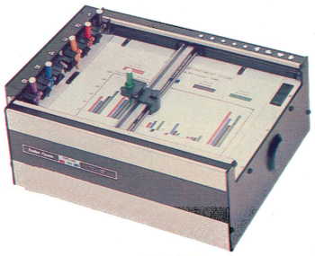
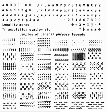
- Making Maps Without Computers
Making Maps with Computers: some background
- computer mapping: computers used in the process of making maps
- automated mapping: computers automate part/all of the mapmaking process
- Geographic Information Systems: Computer hardware and software
for the capture, storage, retrieval, analysis, and output (paper or digital
display) of spatial data. Maps play a vital role in the analysis
(visualization) and display components of GIS.
- a problem with the term "computer mapping" - almost all mapping is now done by computer
- so the term computer mapping has become redundant
A Brief History of Computers and Mapping
- late 1950s mapping experiments with early computers
- SYMAP: Harvard 1965 mainframe; line printer output: patterns made of characters:
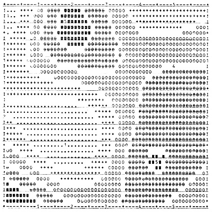
- Similar to earlier use of typewriters to create maps: ca. 1905
- Source: "Machine-Made Line Drawings for the Illustration of Scientific Papers" by
R. A. Daly. American Journal of Science, Mar 1905, p. 227.
- development of computer pen plotters: replicate human tasks: replace people
drawing maps with pens with computers drawing maps with pens:
- late 1970s: development of desktop publishing and subsequently desktop
mapping computer technologies
- desktop publishing: computer set up with graphics and page layout capabilities
connected to print quality output device (all on one desktop)
- Postscript, LaserPrinters
- desktop mapping: all computer operations necessary to digitally assemble the
map's component parts (base maps, data, lettering, symbols, etc.) and to produce
final output
- OSU MAP, Atlas Graphics, ArcView
- constant change: new computer tools
- animation, interactivity, sound, multimedia, hypermedia, analysis
- future: WWW-based multimedia GIS
Map Making Tools (continued):
Digital File Formats and Conversions
- File: collection of records handled as a basic unit of storage in the computer
- File format: specific way the information has been stored in the file with codes
which tell how to interpret the file. Many different graphic file formats
Common Graphic File Formats
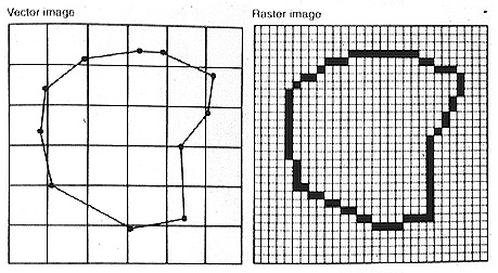
- Raster file formats: Raster software generates files which are made up of pixels
- Corresponds to raster data organization / structure (see Data lecture) & raster-based GIS software
- ex) black square in raster file: turn all the pixels within a four sided area black
- ex) digital satellite data
- ex) a map digitally scanned on a flatbed scanner
- common raster formats include PICT, TIFF, GIF, JPEG
- Vector file formats: vector software generates files which are made up of points,
lines, and areas
- Corresponds to vector data organization / structure (see Data lecture) & vector-based GIS software
- ex) black square in vector file: four points, connect with line, box attribute is black
- ex) USGS DLG data, US Census TIGER data, ArcGIS digital data, Google KML/KMZ files
- ex) a map digitized on a digitizer
- common vector formats include: ArcGIS (.shp, .lyr), PostScript (.ps), Keyhole Markup Language (.kml, compressed as .kmz)
- Usually have to work with both types of formats: convert between, or use both together
- Our lab project: begin with vector (ArcGIS .shp file) and convert to vector .kml and raster (.gif) file.
Common Non-graphic File formats
- for the lab we will need to deal with various text files
- the text data we found on the WWW
- a simple text file (ASCII file, .txt)
- Open with most Word Processors, Spreadsheet software (MS Excel)
- Convert into specialized text formats: Comma delineated text file
- Spreadsheet file formats
- many different types: ex) MS Excel
- Lab: convert a comma delineated file into an DBASE (.dbf) file
- .dbf file can be imported into ArcGIS
- HTML (HyperText Markup Language) files
- Text files used to create what you see on the WWW
- Can convert word processor files into HTML for the WWW (MS Word, Powerpoint)
- Can also generate HTML files in special HTML scripting software (SeaMonkey, Dreamweaver, GoLive)
Assign Lab 2
- first: check that Lab 1 is complete
- second: Lab Exercise 2:
HyperText Markup Language (HTML) and Map Mashups
E-mail: jbkrygier@owu.edu
...to Geog 353 Main Page and Course Description
...to krygier teaching page.
...to krygier top page.
OWU Home
OWU Geology and Geography Home