Geography 222 The Power of Maps
...to Geog 222 Main Page and Course Description
...to Geog 222 Syllabus
...to Geog 222 Course Schedule and Lecture Outlines
...to Geog 222 Laboratory Information and Student Projects
Geog 222 Lecture Outline: Peter's Map Projection Controversy
Update: 10/15/2018
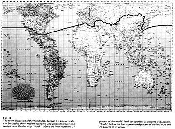
Peters' Map Projection
- © 2001 Akademische Verlagsanstalt. Source.
Technical details of this map projection
- PROP) Peters' book
- the equations Peters' used to create it:

- From The New Cartography by Arno Peters (Friendship Press, NY, 1983)
- the developable surface it is based on: a cylinder
- what it preserves from the spherical earth: areas
- and what it distorts: shape
But we can also look at the map projection as a human created object
- while it is based on equations and the science of map projection
- it was created for specific, political and ideological purposes
- and it was criticized by cartographers for having a political agenda
The controversy reveals that maps are ideological as well as technical representations
- ideological: infused with political or social or cultural belief
- Monmonier: propaganda maps
- ... or just maps as arguments?
The Peters' incident reveals how something as seemingly objective as a map projection
can become embroiled in ideological debates
- It also raises the question as to what is an accurate map
Arno Peters and the Peters Map Projection Controversy
Background: Who is Arno Peters?
1950s: German textbook controversy: While writing his controversial textbook, Peters apparently came to believe that the world
maps available in text books were highly problematic
- argued that the Mercator map projection was usually the default
- by the mid 1970s Peters had devised his world map as an alternative
- and he began to make statements about why it was better than the Mercator
The Peters' map projection is now one of the three most widely distributed world maps
- along with the Mercator and whichever map projection National Geographic is using
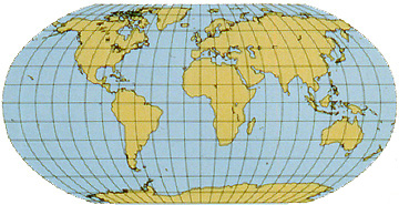
Mercator and Peters Projections with Equator
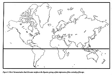
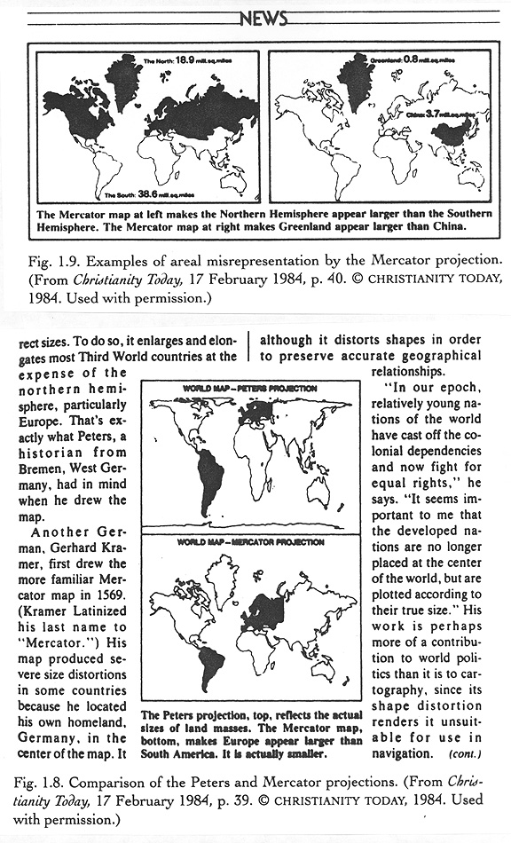
- At the news conference introducing his map projection to the world Peters claimed that the Mercator projection had the tendency to
center the world on Europe: it did!
- It distorted the relative sizes of land masses, inflating the northern areas at the
expense of the equatorial regions: it did this too!
Peters: "the Mercator projection overvalues the white man and distorts the picture of the
world to the advantage of the colonial masters of the time"
Ward Kaiser: "the Mercator portrays a colonialist and racist mentality"
The bottom line:
- the Peters map is for anyone with a true devotion to a progressive and
liberal understanding of global social issues
- It empowers the 3rd world by showing its actual landmass size in relation to the first world
- It makes a profound political statement favoring the 3rd world and its social issues, reversing
what Peters sees as the profound political statement of the Mercator, which favors the
1st world
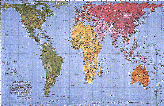
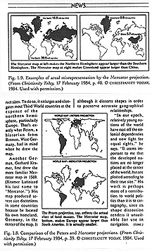
Christianity Today Clipping: the Peters Projection
- adopted by many different organizations as their official map projection
- United Nations: distributed over 60 million copies
- Christian Aid organization: sold over 15,000 copies
- Lutheran Church: distributed 6,000 copies
- promoted by National Council of Churches, other Methodist groups
- promoted by Willy Brandt, former chancellor of West Germany and Nobel Peace Prize winner
- promoted by former Pope John Paul
Proponents of the Peters' Map Projection have created teaching materials:
- Teaching a New World Vision: Ward Kaiser
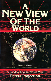
- © 1993, ODT, Inc. Source.
"The transformation of the world begins in the transforming of our minds, and the
renewal of our minds begins with the transforming of the images we entertain:
images we hang on our walls and images we carry with us in our
heads."
Tempest in a Teapot: Cartographers Freak
- Loxton: the Peters map projection is a "plague" on cartography
- Porter and Voxland: the Peters map projection is a "provocative" and "mischievous" product of
"a thoroughly confused cartographer" whose work is "perverse and wrong headed."
- German Cartographic Society: the Peters map is "misleading" "manipulative," and "falsifying"
- Robinson: the Peters map is a "cleverly contrived, cunningly deceptive attack" against cartography.
"The land masses are somewhat reminiscent of wet, ragged, long winter underwear hung out to dry on
the Arctic Circle."
- ACSM Bulletin: "American Cartographers Vehemently Denounce German Historian's Map"
- Snyder: "From its initial announcement, the Peters world map has been surrounded by controversy:
in over 40 articles on the subject, cartographers have vigorously denounced a number of Peters'
claims for the map, while he and his supporters have argued that his is the only world map that
meets the concerns of people interested in social issues"
So why the outcry?
In part because Peters' made claims that his map was the best way to map the entire globe
- and cartographers rushed to point out the maps technical inadequacies
Maling: the Peters' projection is not quite equal area because of some minor problems with the
equations used to create the projection
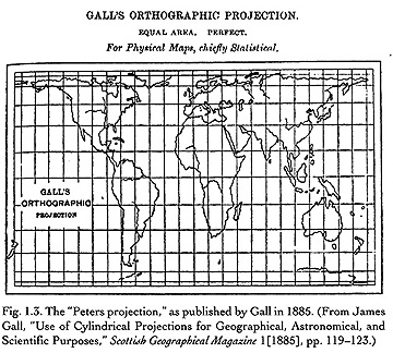
The projection is not "new": the Peters' projection is nearly identical to an obscure map
projection devised in the mid 1800s by the Scottish Reverend James Gall
- Gall Map Projection
1991: World Atlas based on Peters' Projection was published by HarperCollins
- cartographers lobbied the publisher to not publish the atlas
Cartographers have addressed technical issues in criticizing the projection
- is it actually exactingly equal area
- was it truly "invented" by Arno Peters
- are the equations Peters' uses accurate
They have not addressed the political issues Peters' raises: its social agenda
Claim by Peters that his map overcomes the Euro-centric mentality of the Mercator
- not criticized by cartographers as seen as outside the realm of cartography
Alas one of the most important critics of Peters is Arthur Robinson
Internal and External Contexts and Mapping
The internal context: much of what we have been discussing
- issues of geographic and mappable data, how it was collected, and its accuracy
- issues of map generalization, scale, classification, symbolization
- issues of coordinate systems and map projections
But there is also an external context as revealed by the Peters' map controversy
- what culture produced the map and why?
- what social forces shaped the creation of the map and why?
- what political and ideological beliefs shape the map?
Peters' world map is clearly more understandable from the latter perspective
- map projections have a "subliminal geometry"
The question is: do "neutral" things like the map projection and where it is centered
and what it distorts affect our world view or not?
Thomas Saarinen: gathered over 3,800 sketch maps of the world by children from 49
countries in a National Geographic sponsored research project
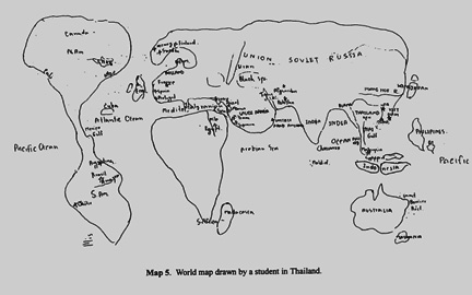
- Children's Mental Maps of World: Looks like the Mercator Projection,
which greatly exaggerates areas in the North. From: T. Saarinen. "The Euro-centric Nature of Mental
Maps of the World." Research in Geographic Education 1:2, 1999.
- most, even those in the 3rd world, centered the world on Europe
Kids Mental Maps of World
Saarinen concludes: "A colonial mentality and Euro-centric image of the world still remains dominant in
many places a quarter of a century after the end of the colonial era"
Recent news:
Boston public schools map switch aims to amend 500 years of distortion
So think about this:
- Do you buy Peters' argument that the Mercator is one of the most popular maps because
it is centered on Europe, and enhances Europe and North America over the equatorial 3rd world?
- Do you buy the argument that if an organization or individual is interested in 3rd world
issues they should adopt and use Peters' map?
There is no absolute answer to these questions, but what seems clear is that the Peters map
and all maps are part of a larger cultural, social, and political context
- © 2001 Akademische Verlagsanstalt. Source.
For more information:
E-mail: jbkrygier@owu.edu
...to Geog 222 Main Page and Course Description
...to krygier teaching page.
...to krygier top page.
OWU Home
OWU Geology and Geography Home