Geography 222 The Power of Maps
...to Geog 222 Main Page and Course Description
...to Geog 222 Syllabus
...to Geog 222 Course Schedule and Lecture Outlines
...to Geog 222 Laboratory Information and Student Projects
Geog 222 Lecture Outline: Map Accuracy
Update: 11/7/04
...Review
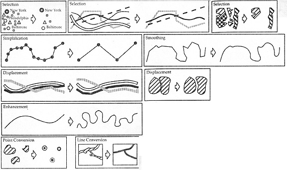
III. Map Abstraction and Infrastructure
Map (or cartographic) Abstraction: "the process of transforming geographic data,
which represents the actual human and physical environment, into a map
- Map Content, Map Scale, Map Generalization, Map Symbolization
Map Infrastructure: basic elements upon which all maps are constructed
- locational reference systems, map projections, accuracy
Summary: Map Projections
1. What are the basic characteristics of the map projection process?
- how does map projection work?
- lumpy earth, transformed into a sphere,then projected onto a flat surface
2. What kind of flat surface to we project the spherical earth on to?
- flat surface, a cone, and a cylinder: projection families
3. What are the basic kinds of map projection distortions?
- preserving area: equivalent projections
- preserving shape: conformal projections
- cannot preserve both area and shape
- preserving distance: equidistant projections
- cannot preserve both area and distance
- preserving direction: azimuthal projections
- can preserve direction
- and area OR shape OR distance
- compromise: don't preserve area, shape, distance, or direction
- but minimize distortion of all of these: good default for world maps
Next...Map Accuracy...
Accuracy: "The quality or character of what is precise"
Map accuracy: "the true-to-reality nature of maps"
- but map accuracy is complicated...
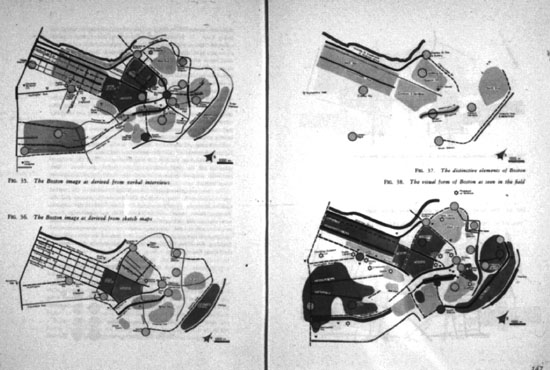
- Are mental maps inaccurate?
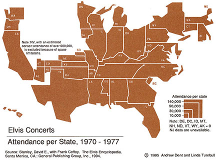
- Are cartograms inaccurate?
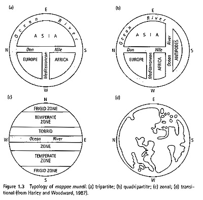
- Are Medieval European "Mappamundi" (world maps) inaccurate?
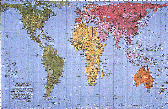
- Is the Peter's Map Projection inaccurate?
Accuracy is complicated: difficult to judge what accuracy means without
understanding the particular map and its intended use
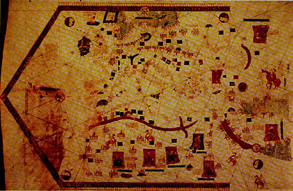
- Portolan Chart
- There is no general standard of accuracy by which all maps can be judged
What Kinds of Questions about Map Accuracy can a User Ask?
1. Are the Factual Details on the Map Accurate?
Map series by governmental agencies have strict regulations and editing guidelines
- most maps don't have such stringent standards
Examples
- ex) Features are left off of the map by accident
- ex) The maps that exist are crappy
- PROP) Trewartha book
- ex) editing errors
- Oops.
In all these cases
- the errors are mistakes
- the errors would be corrected if they were known
- the errors could be eliminated by careful editing
Purposeful errors
Examples
- Copyright traps: what they are
- ex) Maps deliberately manipulated for political or military purposes:
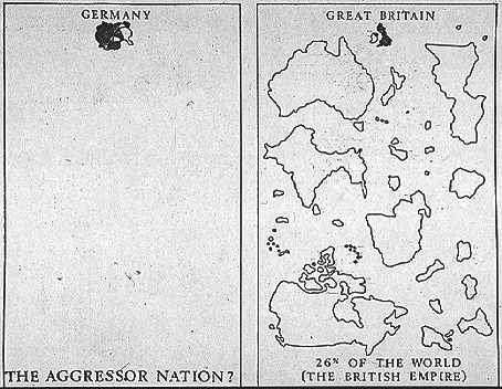
- Propaganda Maps
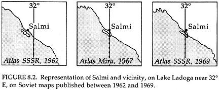
- Cold War Soviet topographic maps
2. Are the Positions of the Mapped Features Accurate?
Positional accuracy
PROP) US Topo Map
USGS Topographic Maps have set standards of positional accuracy
- and all maps in the series must meet these standards
- such maps are created by the USGS and private contractors
- to check accuracy, selected maps are tested
Specific standards for a 1:24000 topo map:
- up to 10 percent of well defined points can be greater than 1/30th of an inch
away from where they should actually be on the map
- up to 10 percent of elevations can be more than 1/2 the contour interval away
from where they should actually be on the map
- if more than 10 percent of the points and elevations are off: remake the map
- not all points and elevations are checked: just a sample
- you cannot say that any given point meets the standards: but the map does in general
This is about as good as it gets: many maps have no set standards
Further interesting issue: we don't always want the most positionally accurate map!
Recall the idea of map generalization
- how generalization adds purposeful locational inaccuracies
3. Is the Abstraction of the Mapped Features Accurate?
- Recall that reality - and the features out in the environment - are complicated
- Feature: "Some thing inherent and distinctive"
- Features in the natural and human environment:
- tangible, concrete: hills, rivers, trees
- intangible, abstract: boundaries
Tangible and intangible features have dimensionality
- We can set some standards by which we can judge the abstraction behind this process
- USGS topo maps: have set abstraction standards
- ex) what is "woodland": green on map
- "an area of normally dry land containing tree cover or brush that is potential
tree cover. The growth must be at least 6 feet tall and dense enough to afford
cover for troops"
- guidelines which can be tested to see if the mapmaker has properly abstracted
the complicated vegetation landscape into the category of "woodland."
In most cases there are no set standards
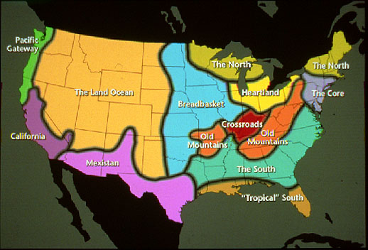
- Cultural Regions of the US
4. What is the Temporal Accuracy of the Map?
- The data on maps has a time
Recall that maps kill!
- News) "Ski Lift Cable is Not Shown on Map Used by U.S. Pilot"
- News) Accidental Bombing of Chinese Embassy
More mundane problem, but still important:
WWW) Census Data: Average Income
- average income (divide population into total income)
- but uses 2000 population and 2002 income data
- population may have changed between 2000-02
How to judge temporal accuracy
- does the map have a date?
- are the sources the map is based on noted; what is their date?
- be aware that most maps include data collected at different times
5. Is the Cartographic Symbolization Accurate?
Poor or bad map symbolization choices
- at best: slow down ability of people to interpret patterns:
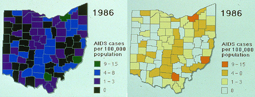
- Poor and Good use of Color on Choropleth Map
- at worst: misinterpretation of map and data
- Reverse of dark means more convention
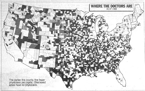
6. Does the Detail of the Data vary over the Map?
- the detail of the data varies over the map
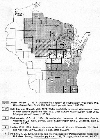
- Wisconsin sand and gravel map
- may look coherent but many maps have been compiled from data collected at very
different scales
- implications
7. Have Printing Problems Muddled the Look of the Map?
In the past, this was usually of a problem with the quality of the map printing
Today: problems caused by computers
- what gets printed is not always what you see on the computer screen
- color maps printed in black and white on laser printers
Issues which affect map accuracy can start with the data (before mapping) through
to the end (when you try and print the map)
Effective map users and makers comprehend the myriad of ways inaccuracies can occur
on maps
Communicating Map Accuracy
Given that all maps have some kind of inaccuracy, cartographers have worked to come up
with ways to communicate to map users the fact that inaccuracies exist on a map
Strategies for Communicating Map Accuracy
Common problem with maps: some information is highly detailed and accurate,
and other information is not
People tend to assume that all the mapped data is as accurate as the most accurate data
- Solution: generalize all the data to the level of the least detailed data
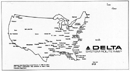
- Delta Airline map
Communicating data accuracy with symbols, notations, disclaimers
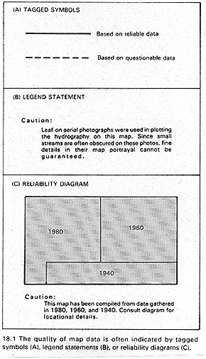
- Communicating Accuracy
- broken line to indicate lower level of accuracy than solid line
- verbal notation on map warning of map accuracy problems
- reliability diagrams
- Wisconsin sand and gravel map
Digital Data and Map Accuracy
- The capacity to collect, process, and map data with computers is accentuating the
importance of map accuracy issues
- In some cases new technologies are allowing us to more quickly and cheaply collect data
directly from the environment
- However, much digital data is based on existing, non-digital sources
- The creation of "cartographic databases" - digital databases of information taken
from pre-existing paper maps - raises some additional accuracy concerns
Geographic Information Systems
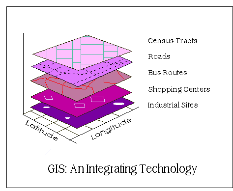
- GIS Layers
From a technical perspective
- methods for data input: digitizing, scanning
- methods for data integration: make different data sets work together
Useful because this allows us to do some cool analytical things
But what does this assume?
- assumes that all the different "layers" of information are equal
- data is collected at the same time
- data is collected at the same level of detail
- data meets some basic accuracy standards
- data has been edited for errors
- and rarely is this the case
All sorts of odd stuff happens when we are digitizing and combining and integrating
data from a diversity of sources, times, and collected for different purposes by
different agencies and individuals
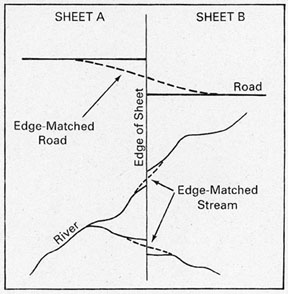
- Edge matching in digital maps
Data of differing levels of detail
What happens when we impose these and use them together?
- anyone can easily create new digital maps by combining layers together
- and they can pass this new digital cartographic database along to someone over the
internet; and this person can combine that database with different cartographic
databases...and so on
- and often information about the differing levels of accuracy and how the data
has been manipulated is lost
- errors are propagated: "extended over a considerable area or space"
- Error propagation in GIS and digital mapping: errors spread around
digitally as digital data sources are used and reused in the process of
creating new digital maps
Attempts to deal with this issue: metadata: data about data
- Dependable digital geographic data will include detailed metadata including:
- identification information: general description of the data
- data quality information: in terms of data quality standards
- spatial data organization information: how spatial
information in the data is represented
- spatial reference information: coordinate and projection information
- entity and attribute information: map data and associated attributes
- distribution information: data creator, distributor, and use policy
- metadata reference information: metadata creator
- citation information: how to cite information when used
- temporal information: when data was collected, updated
- contact information: how to contact data creator
- Source: Longley et al., Geographic Information Systems and Science, 2001
- represent the quality on the map
- include reliability diagrams
New mapping technologies can extend our map analysis capabilities, but they can also extend
and amplify errors and accuracy problems that we have always had to deal with in maps
As you engage in making maps keep in mind the complexities of map accuracy...
- 1. Are the Factual Details on the Map Accurate?
- 2. Are the Positions of the Mapped Features Accurate?
- 3. Is the Abstraction of the Mapped Features Accurate?
- 4. What is the Temporal Accuracy of the Map?
- 5. Is the Cartographic Symbolization Accurate?
- 6. Does the Detail of the Data vary over the Map?
- 7. Have Printing or Reproduction Problems Muddled the Look of the Map?
Pay attention to the ways in which map makers tell map users about accuracy
- symbolizing accuracy
- reliability diagrams
- metadata
Consider the consequences of technological change in mapping and the propagation
and amplification of accuracy problems
E-mail: jbkrygie@owu.edu
...to Geog 222 Main Page and Course Description
...to krygier teaching page.
...to krygier top page.
OWU Home
OWU Geology and Geography Home