...to Geog 111 Main Page and Course Description
...to Geog 111 Syllabus
...to Geog 111 Course Schedule and Lecture Outlines
...to Geog 111 Course Project
Review
Karst and Hydrothermal Processes: underground water
1. Karst Processes and Landscapes
2. Hydrothermal Features
Next: Deserts and Glaciers: dry and ice...
Desert Landforms
McKnight 8.19: Dry climates
Desert landforms: processes which shape them are related to those that shape
landforms in more humid areas: but there are key differences
1. The Work of Water in Dry Regions: Fluvial Processes
1a. Surface Water in Deserts
McKnight 18.4: Nile River
Humid regions: characteristics of rivers?
Desert regions: characteristics of rivers?
McKnight 18.6: Dry Lake Beds in Australia
McKnight 18.8: Playas in Western US
The real effect on desert landforms is from fluvial processes: flowing water
1b. Fluvial Erosion in Arid Lands
Fluvial (flowing water) processes are most important way desert landforms are shaped
McKnight 18.10: Slope in Dry and Moist Areas
McKnight 18.11: Bornhardt
McKnight 18.12: Australian Bornhardt
McKnight 18.13: Pediments
1c. Fluvial Deposition in Arid Lands
McKnight 18.14: Piedmont
Generic term for the area at the foot of a mountain range
In desert areas: zone of fluvial deposition
Fluvial erosion and deposition create unique desert landforms
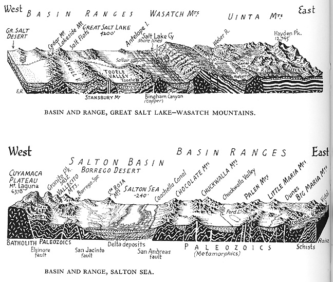
1d. Desert Fluvial Landforms: Basin and Range Terrain
Basin and range region: huge area, minimal external drainage
Raitz Landforms Map
McKnight 18.26: Basin and Range
McKnight 18.27: Alluvial Fan Image
1e. Desert Fluvial Landforms: Mesa and Scarp Terrain
Map: San Juan Pueblo, NM
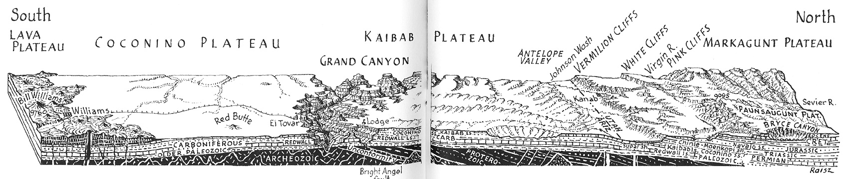
McKnight 18.25: Basin and Range and Mesa and Scarp Landscapes
Four-corners area of the US Southwest
McKnight 18.29: Mesa and Scarp Photo
McKnight 18.30 Cross Section
McKnight 18.33: Pinnacles, Buttes, Mesas, Plateaus
Weathering and erosion: sapping
McKnight 18.34: Badlands
2. The Work of the Wind in Dry Regions: Aeolian Processes
Wind is closely associated with deserts but plays a somewhat limited role in shaping desert landforms with the exception of sand dunes
Aeolian processes: related to the movement of air over the earth's surface
2a. Aeolian Erosion and Transportation
McKnight 18.18: Aeolian Transportation
Deflation: movement of loose particles through the air or along the ground
Abrasion: natural 'sandblasting'
2b. Aeolian Deposition
Sand dunes: one of the most distinctive desert landforms
McKnight 18.19: Sand Dune Movement
McKnight 18.20: Common Dune Patterns
Barchan: usually mobile dunes on a stable (eg., non-sand) surface
McKnight 18.20: Common Dune Patterns
Traverse dunes: less uniform, linear dunes
Seifs: linear, parallel, ridges of sand
2c. Desert Aeolian Landforms
McKnight fig. 18.1: Erg
Ergs
McKnight 18.3: Reg
Regs
Hamada
Sum: Desert Landforms
1. The Work of Water in Dry Regions: Fluvial Processes
Key: despite its scarcity, water is the most important external landform shaping agent in dry regions of the world
1a. Surface Water in Deserts
1b. Fluvial Erosion in Arid Lands
1c. Fluvial Deposition in Arid Lands
1d. Desert Fluvial Landforms: Basin and Range Terrain
1e. Desert Fluvial Landforms: Mesa and Scarp Terrain
2. The Work of the Wind in Dry Regions: Aeolian Processes
Aeolian processes: related to the movement of air over the earth's surface
Most effective where surface material is fine, dry and not held in place by vegetation
2a. Aeolian Erosion and Transportation
2b. Aeolian Deposition
2c. Desert Aeolian Landforms
Glaciers and Glacial Landforms
McKnight 9.5: The Hydro Cycle
McKnight 19.1a: Pleistocene Glaciation
McKnight 19.1b: Pleistocene Glaciation: US Detail
McKnight 19.1c: Pleistocene Glaciation: Europe Detail
McKnight 19.2: Contemporary Glaciation
McKnight 19.3: Contemporary Glaciation in N. America
Focus on the effects of ice and glaciers which directly affect landforms
Periglacial processes: zone beyond the extent of glaciers and ice
Sea level changes: if more water is stored as ice, there is less water in oceans
Crustal depression: weight of ice caused earth's crust to sink: up to 4000 feet
Precipitation changes: increase in precipitation particularly during glacial retreat
1. Glaciers Formation and Flow
Glaciers form when there is a year to year accumulation of snow
McKnight 19.8: Snow to Ice
Glacial flow
McKnight 19.10: Glacial Flow vs Glacial Advance
Glacial ice is always flowing, even though the glacier itself may not be advancing
McKnight 19.9: Glacier Cross Section
Overall result of glacial flow is a form of erosion by water
Glacial erosion accounts for only about 7% of erosion (now)
2. Mountain Glaciers
McKnight 19.5: Mountain Glaciers
McKnight 19.6: Alpine Glaciers
McKnight 19.28: Landforms shaped by Mountain Glaciers
3. Continental Ice Sheets and Glaciers
McKnight 19.1a: Pleistocene Glaciation
3a. Development and Flow of Pleistocene Glaciation
3b. Erosion by Ice Sheets
Glacial movement tends to smooth out the land beneath it
Effectiveness of erosion by glaciers
McKnight 19.16: Plucking
McKnight 19.11: Glacial Abrasion
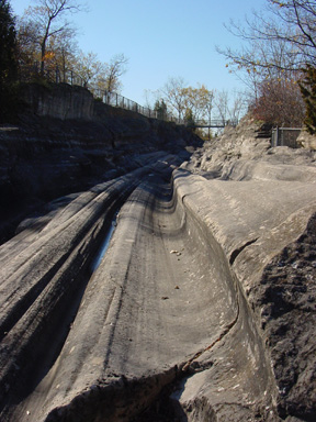
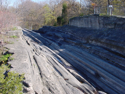
Results: a smooth but not flat terrain
Transportation by Glaciers
3c. Deposition by Ice Sheets and Glaciers during Pleistocene
Pleistocene glaciers
Drift: any material moved by glaciers
Many glacial deposits are unstratified and amorphous (not particular shape)
McKnight 19.13: Till Photo
Till: material deposited directly by moving or melting ice, with no meltwater flow or redeposition involved; usually occurs at the edge of a glacier
Till plain:
McKnight 19.14: Erratic Photo
Erratics: huge fragments of rock, carried and deposited by glacier
Other glacial deposits do have particular patterns: stratified
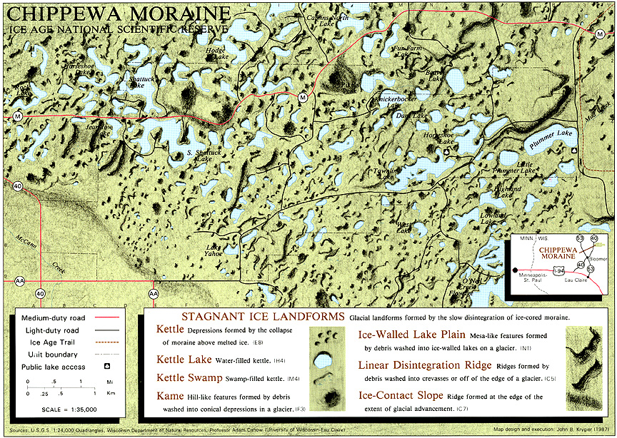
Moraine: irregular rolling hills and ridges; concentrations of glacially deposited materials
McKnight 19.20: Terminal Moraine
Terminal moraine:
McKnight 19.18: Glacial and Glaciofluvial Features
Recessional moraine:
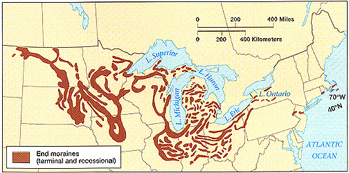
WWW) Terminal and Recessional Moraines in US Midwest
Usually shaped in concave arcs bulging outward in the direction of ice movement
McKnight 19.18: Glacial and Glaciofluvial Features
Ground moraine:
Drumlins: ridges aligned parallel with the direction of the ice movement
Glaciofluvial Features
McKnight 19.18: Glacial and Glaciofluvial Features
Outwash plains:
Eskers: long sinuous ridges of stratified drift
McKnight 19.23: Kame
Kame: small, steep mounds or conical hills
McKnight 19.19: Kettles
Kettle: chunks of ice left behind as glacier melts
Sum: Glaciers and Glacial Landforms
1. Glaciers Formation and Flow
Overall result of glacial flow is a form of erosion by water
2. Mountain Glaciers
3. Continental Ice Sheets and Glaciers
3a. Development and Flow of Pleistocene Glaciation
3b. Erosion by Ice Sheets
...transportation by glaciers...
3c. Deposition by Ice Sheets and Glaciers during Pleistocene
E-mail: jbkrygier@owu.edu
...to Geog 111 Main Page and Course Description
...to krygier teaching page.
...to krygier top page.