...to Geog 111 Main Page and Course Description
...to Geog 111 Syllabus
...to Geog 111 Course Schedule and Lecture Outlines
...to Geog 111 Course Project
Surface of earth of interest to geographers
Maps are a great tool to help understand and analyze the earth's surface
Today:
1. The Nature of Maps
Map: a two dimensional representation of the spatial distribution of selected phenomena; usually components of the human or physical landscape
A scaled drawing of a portion of a landscape, representing the area at reduced scale and showing only selected data
McKnight fig 2.1: Different kinds of maps
1a. A Matter of Scale
Map scale
Maps are almost always smaller than the portion of the Earth's surface they portray
Lewis Carroll "Sylvie and Bruno Concluded"
Map Scale Types
Graphic scale: line or bar on map represents some set distance
Word scales: describes the scale of the map in words
Fractional scales: representative fraction: a proportion between map distance and Earth distance
Large and Small Scale Maps
McKnight fig 2.3: comparing map scales
Large scale / Small scale distinction is based on the representative fraction
1b. Map Graticule
Necessary to have a means of locating phenomena on the earth and on maps
McKnight fig 1.17: latitude / longitude
1c. Map Projections
Globes have the least distortion from the actual earth
Problem: have to flatten out the Earth to get it on a flat surface
Inevitable distortions occur when you project a map
Always some kind of distortion: of size, shapes, ...
McKnight fig 2.10: conformal vs equivalent map projections
1d. Map Generalization: using judgement in the elimination of detail and
reduction of the number of features on the original map
Mark Monmonier: "Reality is three-dimensional, rich in detail, and far too factual to allow a complete yet uncluttered two-dimensional graphic scale model. Indeed a map that did not generalize would be useless." (How to Lie With Maps)
1e. Map Content: reference vs. thematic
reference maps: general use (for many purposes), focus on and emphasize the location of things in the environment - many different purposes; like a general world atlas or encyclopedia
thematic maps: particular use or theme: focus on and emphasize the spatial patterns of
one or several human or environmental phenomenon
1f. Map Symbolization
symbol: A thing representing something else because of relationship, association, convention, or resemblance.
Special Map Symbol: Isolines
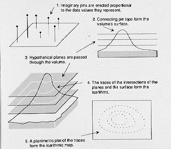
Basic characteristics of isolines
2. Developments in Mapping: Computer aided Mapping
2a. Global Positioning System (GPS)
McKnight fig 2.16: 24 satellites around Earth, transmitting positioning information back to earth
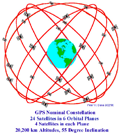 GPS Orbits
2b. Remote Sensing
Remote sensing: any measurement or acquisition of information by a recording device that is not in physical contact with the Earth's surface
Aerial Photographs
Multispectral Remote Sensing
Increasingly: remote sensing (airplane, satellite) sensors gather energy (passively, or actively) from different parts of the electromagnetic spectrum
2c. Geographic Information Systems: GIS
Computer hardware and software for the capture, storage, retrieval, analysis, and display of spatial data
GIS is basically digital maps linked to digital databases
McKnight fig 2.29: layers which can be linked together in a coordinate system (lat/long)
Sum...
Six basic map attributes of all maps - paper or digital
Developments in mapping
Much more on all this stuff in Geography 222: The Power of Maps
E-mail: jbkrygier@owu.edu
...to Geog 111 Main Page and Course Description
...to krygier teaching page.
...to krygier top page.