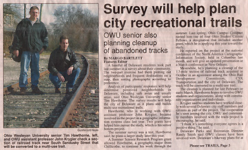
Click to Enlarge
Delaware (Ohio) Gazette
Friday November 22, 2002.
Click to Enlarge
|
Mapping Campus-Community Collaborations:
Integrating Partnerships, Service-Learning, Mapping and GIS National Institute for Technology and Liberal Education: National Conference, 2004 Voyage to Ithaka: Technology, Collaboration, and the Future of Liberal Arts Colleges November 7-9, 2004 Last Updated: November 28, 2004 Abstract: Liberal arts institutions across the country are engaged in collaborative partnerships with neighboring communities to address local issues and concerns. On many campuses, Geographic Information Systems (GIS) technologies shape the analysis of these local conditions. Community GIS embodies partnerships between educators, students, and community members, applying GIS to projects of value to the community. We explore service-learning as both a community-based research tool and an innovative pedagogy, and key principles and effective practices of successful community partnerships. Examples of collaborations between colleges and communities using GIS are detailed, as are key aspects of successful collaborations. I. Mapping and Geographic Information Systems & Science II. Service Learning, Reflection, and Partnerships: The University and the Community III. Mapping Campus-Community Collaborations: The MITC Sponsored Conference IV. Community Mapping and GIS Projects: Extended Examples V. Closing thoughts on Community/University Collaboration with GIS |
Presented by: Timothy Hawthorne Department of Geology and Geography West Virginia University thawthorne@geo.wvu.edu John Krygier Department of Geology and Geography Ohio Wesleyan University jbkrygier@owu.edu Krygier WWW Pages Melissa Kesler Gilbert Director of the Center for Community Engagement, Department of Student Affairs Otterbein College MGilbert@otterbein.edu |
|
Click to Enlarge |
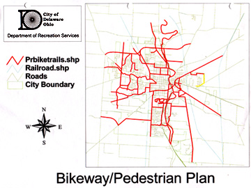
Community GIS Project: Ohio Wesleyan faculty & students working with community
members & planners to develop city and county recreational trail plans. Delaware (Ohio) Gazette Friday November 22, 2002. |
|
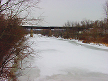
Click to Enlarge |
Actual results: Rails to Trails conversion of CSX Railroad corridor through Delaware. Crosses Olentangy
River on rusty but picturesque 19th century RR bridge:
|
 Project Varenius Home Page |
"GIS is alternatively seen as a powerful tool for empowering
communities or as an invasive technology that advantages some people and
organizations while marginalizing others. This initiative will examine
the two-edged nature of the GIS sword by defining and executing research
projects that involve researchers looking critically at the use of GIS
by community groups or by others using the technology in ways that
impact individuals and communities." From Empowerment, Marginalization, and Public Participation GIS homepage. |
|
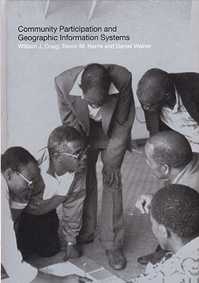
The fundamental question: "how does GIS affect the ways in which communities are
able to build awareness of their surroundings, develop consensus, and argue
persuasively for a better future?" Michael Goodchild from the Forward to Community Participation and Geographic Information Systems 2002. An excellent overview of cross-disciplinary work on Community GIS projects worldwide, and related literature, up to 2001. Keywords: GIS and Society Public Participation GIS (PPGIS) Participatory GIS (PGIS) Community GIS (CGIS) GIS2 Critical GIS Feminist GIS |
|
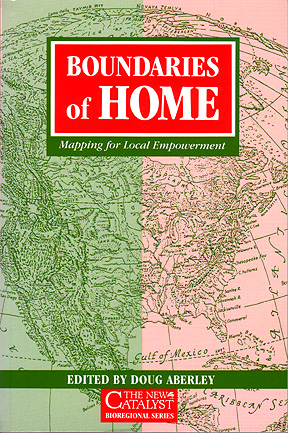
"In our consumer society, mapping has become an activity
primarily reserved for those in power, used to delineate the
'property' of nation states and multi-national companies. The
making of maps has become dominated by specialists who wield
satellites and other complex machinery. The result is that although
we have great access to maps, we have also lost the ability
ourselves to conceptualize, make and use images of place - skills
which our ancestors honed over thousands of years." Doug Aberley, ed., Boundaries of Home, 1993, p. 1 Low tech, grassroots, critical but does offer ways to wrestle mapping away from the 'powers that be.' |
|
"Geographic Information Systems (GIS) technology provides great value for
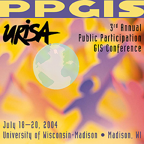
empowering citizen organizations and revitalizing communities." "The use of GIS as a participatory tool raises critical technical, social, and theoretical issues that interest both practitioners and researchers who are concerned with the social consequences of its use. The PPGIS Congress will bring together participants with a rich diversity of experiences that include citizens and citizens groups, public officials, planners, technicians, librarians, policy scientists, and researchers. Presentation topics will range from urban neighborhoods to indigenous people, developing nations, environmental organizations, and virtual communities." From Public Participation GIS Conference PDF: Public Participation GIS (PPGIS) Guiding Principles by Doug Aberley and Renee Sieber Excellent summary of Community Mapping and GIS principles. |
Service Learning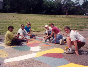
|
GIS community-based work in higher education can be informed by the innovative
pedagogy of service-learning. "Service-learning is a structured learning experience
that combines community service with explicit learning objectives, preparation and
reflection." (Bringle & Hatcher, 1995). Students engaged in service-learning provide
community service in response to community-identified concerns and learn about the
context in which service is provided, the connection between their service and their
academic coursework, and their roles as citizens. Service-learning helps foster
civic and social responsibility, is integrated into and enhances the academic
curriculum, and includes structured time for students and participants to reflect on
the service experience. Bringle, R.G., & Hatcher, J.A. (1995). A service-learning curriculum for faculty. Michigan Journal of Community Service Learning, 2, 112-122. |
Reflection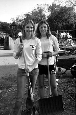
|
It is important in service-learning courses to provide opportunities for students to
reflect on the service activity in such a way as to gain a broader appreciation of the
intersection between their community-based work, their public contribution, and their
academic journey. Reflection can take many forms, including process meetings in the classroom, journal writing, formal essays, workshops, and class discussions. |
Building Community Partnerships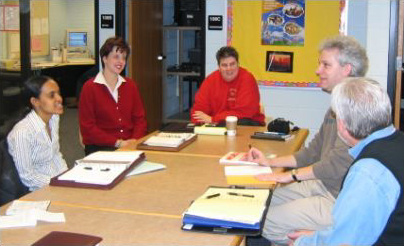
|
Partnership-building for community work between the academy and the community is greatly
enhanced when both faculty and partners share community-identified goals. "For community partners, a good community/campus partnership is characterized by careful preparation, excellent implementation, and meticulous follow-through." |

 Click to Enlarge |
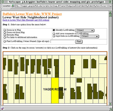
Distinguishing characteristic of PPGIS: Provide access to data and basic GIS functions via a GIS interface to a broad and diverse array of community users. Identify/Find GIS Functions: Users can find existing public information, owner, or building violations. |
 Click to Enlarge |
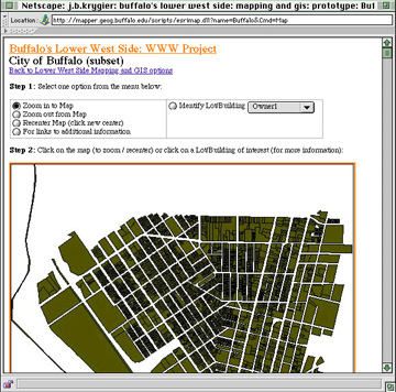
Feverish desire for highly localized data: Problems: Limited data availability at local scale Privacy issues Limited understanding / analysis at one scale Scale Change GIS Functions: Compare neighborhood scale data to city scale data; locate absentee owner properties or home location. |
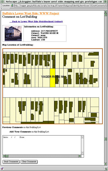 Click to Enlarge |
Distinguishing characteristic of PPGIS: Important for community users to incorporate their own information (local knowledge, information, data) via the GIS interface on the WWW Comment on Property GIS Function: Neighbors notice a house is abandoned, or suspected crack house; report this information via the WWW-based GIS, and added to the WWW site database. An 'open database': interesting implications |
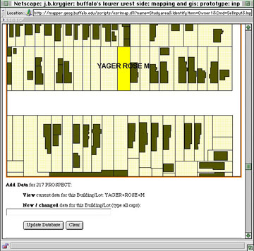 Click to Enlarge |
GIS Database change via the WWW Function: Allows a 'master user' - the community planner - to change the GIS database via the WWW Change owner, violation status, add community derived information after it is checked or verified Functionality of the site varies based on who is using it Provides access to basic GIS functionality to community planner via the WWW (does not have to have actual GIS software). |
Most General Conclusion: The Technology for such community projects works! But the real problems are NOT technology! Project never implemented due to community, social, and cultural context. |
 Click to Enlarge |
Delaware City Recreational Trails Plan Initial map, data and plan devised by OWU GIS course and community members was developed and implemented when Randy Smith was hired as city recreation director in 2001. Smith has acquired development funds and property to be converted into trails Exaction: 10% of any property being developed given to city for parks/recreation; some taken for trails. Developers must link any trails in development to city plan. |
 Click to Enlarge |
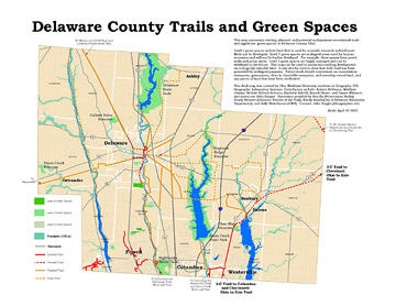
Delaware County Recreational Trails Plan Initial map, data and plan devised by OWU GIS course with Randy Bennett and members of the Delaware County Friends of the Trail (non-profit Rails-to-Trails organization). Continued work, spring of 2004. ArcIMS WWW GIS site of county plan under development. |
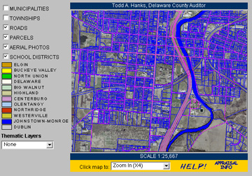 Click to Enlarge |
Conventional GIS Data: Delaware Area Land Information System (DALIS) Extensive, county-wide, frequently-updated GIS data from Delaware County. High-resolution Orthophoto, parcels, road centerline, road right-of-ways, railroads, political boundaries, hydrology, subdivisions, 100 and 500 year floodplains, soils, census tracts, block groups, and blocks, 2' contours, etc. Potential trails generated to connect certain parcels (schools, parks, etc.), account for terrain (contours), use existing right-of-ways, assess private vs public property, buffers, etc. DALIS Downloadable GIS data |
|
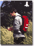
Conventional GIS Data: GPS for field data collection. Survey-quality GPS unit, Ipaq handheld computer. Data collected in same coordinate system (SPCS) as Delaware County GIS data. Exported as Arc .shp file. |
 Click to Enlarge |
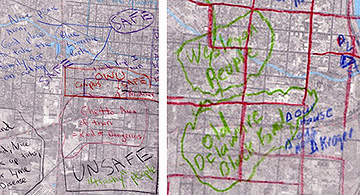
Unconventional GIS Data: Mental Mapping for Qualitative local data Mapping the 'perceived' landscape: fear, safety, neighborhood characteristics such as race, class, etc. Drawn with pencils on tracing paper over air photo of Delaware. |
|
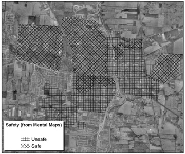
Unconventional GIS Data: Composite Mental Map of Perceived Safety Compiled from 18 mental maps of Delaware by community members. Include as layer in GIS and use when determining potential trails; use in tandem with more conventional GIS data for analysis. |
|
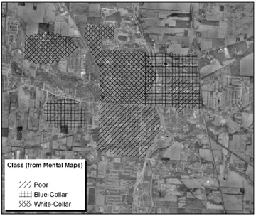
Composite Mental Map of Economic Class |
|
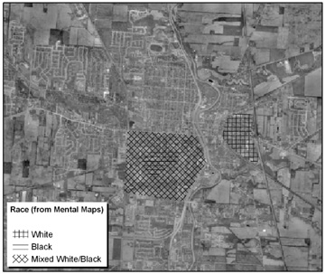
Composite Mental Map of Race |
|
Click to Enlarge |
Relate proposed Rail-to-Trail Conversion to perceived safety, class, race. Mapping a geography of potential conflict about trail development. |
 Click to Enlarge |
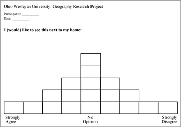
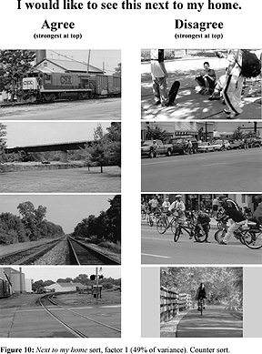
Unconventional GIS Data: Picture Sorts and Q-Method (Factor Analysis) Assessing preferences towards Railroads and Trails: 19 photos of Rail and Trail and urban phenomena sorted by 18 participants into this 'Strongly Agree' to 'Strongly Disagree' structure. Sorts analyzed by PQMethod Software which pulls out significant factors (commonalities in sorting) among all community member sorts. Pictures sorted two times based on two criteria: "I would like to see this next to my home." "I would like to see this in the city of Delaware." Hypothesis: General assumption that reaction against recreational trails is more likely among adjacent property owners ('NIMBY'); more positive reaction at the community level. |
 Click to Enlarge |
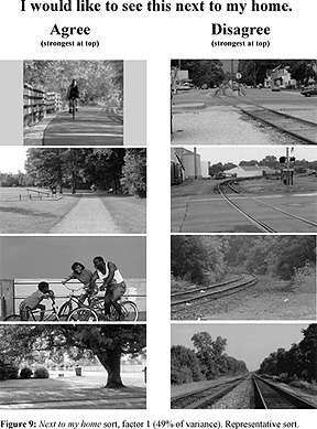
Example Picture Sort A representative sort of the most and least favorable things to have next to home. |
 Click to Enlarge |
Example Picture Sort A sort which runs counter to most of the community member sorts. |
"I would like to see this next to my home" sorts: factor with eigen value over 1 is significant Factor 1 (eigen value 7.9; explains 49% of variance): interpreted as "trails and green spaces are better than rails and industrial spaces." Factor 2 (eigen value 2; explains 13% of variance): interpreted as "trails and green spaces are better than roads and development." |
Relate factors, different images, and comments made by participants during and after they
sorted the images. Importance of counter sorts! Complex, open to diverse interpretations! Advised by Q Method expert. Interpretation More support for trails next to home than anticipated; strong opposition to industrial spaces near home (not surprising); concern about roads and development near home (not surprising in rapidly developing Delaware). |
"I would like to see this in the city of Delaware" sorts: Factor 1 (eigen value 6.8; explains 33% of variance): interpreted as "trails and green spaces are better than rails and industrial spaces." Factor 2 (eigen value 1.8; explains 21% of variance): interpreted as "trails and green spaces are better than unsafe spaces (roads, traffic)." Factor 3 (eigen value 1.4; explains 9% of variance): interpreted as "trails and green spaces are better than roads and development." |
Interpretation Support for trails but for more diverse and diffuse. Emphasis on what participants do not want to see in Delaware as a community. Trails favorable, but concerns about development (roads, safety, commercial development, etc.) play a more significant role than they did in the "next to my home" sorts. "In my neighborhood, people are always walking and riding bikes with their little kids. I don't want more people coming into the area, because it will bring more congestion and unsafe roads, plus I don't know all my neighbors like I used to...." |
General Conclusions: Messy, complicated, rich set of data generated! Trail development often focuses on adjacent property owners, but pay attention to how trails fit into larger picture of community development. Support for trails may be more a concern about safety and problems associated with rapid development. Ambiguity of trails: Signify a shift from older industrial economy (railroads) to new service economy. Trails (particularly Rails to Trails) are thus part of the changes driving rapid development, concerns with safety, growth, etc. |
Future Work Evaluate images and select new set to further explore conclusions and to enhance ability to map the results. Important factors can be linked to land use data (available for each parcel in the county) to create a map of favorable and unfavorable land use "next to home" and "in Delaware." |